skip to main |
skip to sidebar
The blogosphere is filled with arguments and examples of how good design can add to the intrinsic value to a building. I’ve avoided such assertions myself, partially because I am not as well-versed in design as many others out there, and largely because I’ve never believed it to be true. So much of what comprises good design today is imbued with an exhaustive self-awareness: not just the designer’s personalized aesthetic language, but the overt references to whatever design tenets are en vogue. The cultural principles that underlie both of these aspirations will inevitably fall out of favor over time—and again, X years later, will most likely experience a resurgence in popularity when the vernacular evokes nostalgia for a particular time period. Such is the cyclical life of a region of individual taste. Thanks to its extreme consciousness of itself, architecture is virtually always meta-architecture—perpetually attuned to the cultural shifts upon which it cannot avoid commenting or outright defying.
So now is just as good of a time as any for me to capitulate—to welch on the design disinterestedness I’ve aspired to for so long in this blog. I have to face the facts. I just love the building in the photograph below!

The S.S. Pierce Building anchors one corner at the heart of Coolidge Corner, an old streetcar neighborhood within the larger City of Brookline, which is itself an affluent suburb just west of Boston. Built in 1897 to house retail and offices for a respected local grocer of the same name, the building is an unabashed example of Tudor Revival, and its organic warmth offers a distinctive contrast from the other structures at this intersection and the surrounding area, such as the Art Deco accents on the building directly across the street.


The comparative height of the building and its timber framing instill it with an unusual, somewhat paradoxical combination of assertiveness and warmth. View it from the façade along Beacon Street to witness how the pitched roof and organic framing material help to mitigate and soften its intended majesty.

Since nearly every other structure in the commercial heart of Coolidge Corner depends almost exclusively on stone or brick—but hardly ever both simultaneously—the S. S. Pierce Building stands out enough to function almost as a landmark. It comes closer than anything else to embodying Coolidge Corner. Whether the building passes muster among the most erudite design scholars is neither here nor there; the fact remains that it catches the attention and diminishes the implicit egalitarianism of a perpendicular intersection—this corner is by almost all metrics the most prominent of the four. It’s the implied center. Considering its stature within this already desirable, pedestrian friendly retail node, it should command an equally lucrative retail mix, right? Perhaps some multi-story department store of premier fashion?


Hardly. Its two first-floor tenants are run-of-the-mill discount national chains. Does this defy expected retail sensibilities? Maybe, if one adheres to the notion that prestigious design attracts prestigious tenants. But conventional retail patterns do not always abide by the ambitions of urban idealists. Corners are always particularly pricy real estate, for the obvious reason of visibility, so it isn’t surprising that national chains with deep pockets would more likely be able to afford the rents than an eclectic local name. Even the tenant one storefront away from the corner undoubtedly pays less for the lease, and in the photograph below it’s a mom-and-pop…

. . .which, incidentally, had closed. The fact remains that it is impossible to calibrate exactly what a structure will house simply through its external appearance. The enduring majesty of the structure might make seem to make it valuable, but the convenient location more than anything ensures that it will rarely confront vacancy. Imagine if the structure sat on a corner in the distressed Roxbury neighborhood of Boston, less than three miles away. It very well could be shuttered on the upper floors with a Payday loan store below; it may still have a Walgreen with significantly higher security; it may have been abandoned and demolished decades ago. My guess is the property manager of the S. S. Pierce Building is perfectly content with these two reliable tenants. A moneyed suburb like Brookline may hope for a slightly more interesting retail mix to reflect the high education and income levels of its consumer base, but when an intersection becomes too prominent, the big names are often the only ones that can afford it. Notice that the other corners also had major brands and franchises: AT&T, Quizno’s, Bank of America, the inevitable CVS (the ubiquitous war between Walgreens and CVS deserves an entirely different blog post). Smaller buildings along Beacon Street and Harvard Street still claim some local retail, but, the big-spending milieu greatly resembles Harvard Square in the nearby suburb of Cambridge (which I blogged about months ago). In both cases, the combination of foot traffic, major transit stops, pedestrian scaled architecture, and high incomes results in a economic development director’s Elysian fields—and a morass of retail volatility.
I’d be willing to venture that Radio Shack and Walgreens are among the most stable elements in Coolidge Corner, while many of the humbler tenants come and go every few years. All too often in the past I’ve witnessed community meetings in which planners lead the constituents to envision both the structures they’d like to see in their neighborhoods, as well as the tenants they hope to inhabit those structures. Aspirational dialogues stimulate creative juices and I would never discourage them, but Coolidge Corner is just one example of many where most or all of the carefully calibrated design elements have come into play marvelously, and the result is a continued demand for further calibration. The dog still wags its tail.
Across most cultures, the animals that comprise what we would call “livestock” remain remarkably similar. Chickens, turkeys, goats, pigs, sheep, cows, and horses are reliably visible in countries with widely variable climates and levels of industrialization. Some of this may be due to a commonly cultivated taste for the meat, milk, and eggs of these creatures, but I suspect this is a minor contributing factor. The truth is, humans domesticated the aforementioned ruminants and fowl because they proved extremely adaptable—not only to a variety of climates but to varying degrees of co-existence with humans. Centuries of livestock farming have proven that horses and pigs respond comfortably to an environment with a heavy human handprint; deer and moose and wolves do not.So it shouldn’t have surprised me as much as it did to see a small herd of cows in the setting captured in the photograph below, taken across the Mississippi River and downstream from Baton Rouge: For those who live in states less dependent than Louisiana on a vast network of flood protection systems, the levee is essentially a magnified earthen berm that protects surrounding lands from a crest in the river. With the exception of bridges, views of the Mississippi in Louisiana are therefore relatively scarce. The quintessential River Roads that parallel the river’s trajectory in Louisiana generally offer this vista:
 But cows on the levee? It provides a droll sight the first time around, and raises interesting questions regarding the ownership of these vast structures. Historically the Mississippi River was the lifeblood of agrarian commerce for the interior of the nation, with New Orleans serving as the urban gateway. The first wealthy landowners in southern Louisiana settled along the Mississippi, forming a concatenation of plantation properties with elevated homes that often fronted this mighty current, which of course was unprotected by levees at the time. Roads at this point were crude and inconsistent; the river provided the primary access to larger settlements such as New Orleans, Baton Rouge, and Natchez. Despite the flood risk, settling by the river made sense because of its transportation role. The riverbanks also offered the only arable land for these Creole settlers; anything more than a few miles from the river often dipped below sea level into unusable swamps. The Mississippi River does not form a valley in south Louisiana—it’s the exact opposite. Essentially, the depositing of silt from the Mississippi has created a natural levee system that made settlements such as New Orleans feasible, since the riparian lands upon which the French Quarter and other neighborhoods rest are the highest points in the region. The Mississippi River is a peak, and everything else around it is low.Now we have superimposed a manmade levee system on top of the one that Mother Nature provided; the most expensive and sophisticated of these come courtesy of the Army Corps of Engineers, while FEMA provides the standards that allow a classification of floodplain status used for the National Flood Insurance Program (NFIP). These elaborate protective barriers have amplified the complexity of levee property ownership, as the world became aware during the exhausting controversy of breached levees flooded New Orleans after Hurricane Katrina. Who owns these steeply sloped strips of land between the River Road and the river itself? It can be a federal agency, but it could also be a State-initiated water management district, a municipality, a district exclusively in charge of levees, or, as is often the case, a private landowner. Maintenance of the levees is always a public responsibility, and in the case of Louisiana the task typically belongs to one of the many levee districts run by each of the parishes (Louisiana’s equivalent of counties) that claims part of the river’s banks. Even if the land is privately owned, the stewards of the levee earned the right of access to the levee top through an easement—various segments of the levee have obliquely angled gravel roads to allow safe vehicular access in a fashion that will not damage the soil or weaken the berm. Some parts of the levee have dirt roads on top. Much of the levee tops in New Orleans and Baton Rouge have pedestrian and bike trails. In recent years, an organization has even sponsored an exhaustive Rouge-Orleans race that stretches the full 124-mile length of the river’s course between the state’s largest metro and its capital.
 It’s amazing, considering all these interventions, that private landowners have still found a way to stake their claim on the lands. Clearly this specific one chose to use it as pasture land. Is it healthy for the cows to graze on such a heavy slope? Surely the dairy farms of Wisconsin and California aren’t perfectly flat, so that should not prove a major impediment. And it could very well imply a sort of mutual benefit agreement between the landowner and the levee district: while the district ideally maintains these structures that protect all the abutting lands from floods, the owner of these cattle has saved the district the trouble of using potentially destructive tractors to mow the levees. Why is it necessary to keep the levees mowed? An excellent question, to which I’m not certain I have an answer, though I suspect that a completely unkempt levee may impede access for vehicles that inspect the structure, and it may attract undesirable wildlife: muskrats and nutria are known to pull grasses by the roots that help stabilize the soil of Louisiana’s levees and wetlands. At any rate, whether a landowner, State agency, or levee district is doing the maintenance, a carefully manicured levee lawn remains the norm and not the exception. The landowner in this case seems to have a permanent operation with cows on the levee, as proven by the legitimate fencing and gates.
 Perhaps this sight isn’t as rare as I am inclined to believe. A Flickr photo of a much more crowded levee/pasture provides some dialogue that suggests this is a common occurrence. A state institution such as the Hunt Correctional Institute (the women’s prison) may actually employ the cows principally as grazers for maintaining the portion of its property that fronts the river. At any rate, the cattle of sweaty south Louisiana seem as placidly adaptive to this unconventional milieu as they have to whatever climate, topography, or confinement method humans have subjected them. Levees may or may not be difficult on the ankle tendons of livestock, but considering the conditions of the modern industrial cattle farm, the steeply sloped banks of the Mississippi are a bucolic paradise.
At long last I conclude a blog series that has proven among the most challenging of any of my essays yet. In the previous two posts, I identified the prevalence of overhead cables throughout the American urban landscape. While it is common practice for new suburban developments is to bury electric wires underground—and the majority of city centers boast a largely undergrounded electrical wire network—vast stretches of the inner city, suburban highways, and virtually all of rural America remain a tangle of wires hoisted by wooden poles and metal pylons. Compared to dense European settlements in countries such as Holland, America still has quite a few unburied electric wires. Among the larger cities, New Orleans may be the one where the greatest proportion of the electrical network stretches nakedly above the streets and sidewalks. Wires are everywhere in the Big Easy, often right up front with all the pedestrian traffic, such as this bustling stretch of Magazine Street.

While the older neighborhoods of most cities (at least those west of the Mississippi, where the majority of America’s comparatively old cities lie) feature unburied, overhead electric wires, in New Orleans they are particularly noticeable. The city may be at a topographic disadvantage: burying cables makes them less susceptible to high winds and fallen trees, but water intrusion poses a considerable problem, particularly in a city that is largely below sea level. Undergrounding of wires is costly no matter where it takes place, but in New Orleans it is particularly onerous and largely impractical. However, many other cities at least have attempted a discreet placement of the overhead wires; I noted in Part II that Chicago’s cables mostly rest in the back alleys, scarcely visible from the front side of residences and storefronts. But New Orleans overwhelmingly lacks alleys, and its concatenation of grids that meet at oblique angles makes it particularly difficult for any straight-line placement of infrastructure—the configuration of parcels within each street block is inconsistent, impeding the ability to integrate a dedicated utility easement at the line between two properties. The property lines for back yards are too jagged and irregular. The only remaining practical place for electric wires is out front above the sidewalks, so the poles and wires mingle with cars and pedestrians.
 My apologies for this cliché, but New Orleans is stuck between a rock and a hard place, when it comes to reducing the clutter of its electric infrastructure. Investment costs for undergrounding wires is high, and it won’t necessarily pay off in improved electric service because underground wires still run a great risk of inundation in a city as flood-prone as New Orleans. And it can’t bury them in the back alleys the way Chicago does, because it doesn’t generally have alleys. If the common perception remains that undergrounding cables equates to modernization, how should the City that Care Forgot proceed in getting rid of all that old-fashioned clutter?I’ve dropped more than hints. Largely out of virtue of necessity, the city’s leadership has eschewed any significant modernization of the electrical network. This benign neglect, though, has spread to other major infrastructural components and has elicited some serious problems. The Sewerage and Water Board has acknowledged that Hurricane Katrina exacerbated an already compromised network; over 50 million gallons of water are leaking each day. The conditions of the roads in the city are the stuff of legend. And though the importance of the levees extends far beyond the City (as does the political responsibility), the entire world is well aware of their precarious state. Compared to the rest of the infrastructure, the electric grid of New Orleans is small potatoes.
Virtually every major city in America suffers from deteriorating infrastructure to a certain degree. But in only a few are the conditions so bad that the awareness of the problem extends beyond the DPW. In New Orleans, the infrastructure consistently falls under public scrutiny: among the examples include the New Orleans Potholes Brass Band; the C’est Levee parade held by the Krewe de Vieux during the first Carnival season after Katrina; or the widely recognized design to the water meters:  Reaffirming the centrality of the crescent-shaped bend in the Mississippi River, various civic groups have adopted this manhole cover’s star-and-moon pattern:
  The design also appears as screen prints on t-shirts, miniature pendants on necklaces, and tattoos on forearms. It is inevitable that, for a city in which copper, steel, and concrete simultaneously protect it from devastation while broadly signaling the selfsame vulnerability, the innards would achieve a greater recognition than in a city that does not depend so much on earth moving for basic operability. Rather than turning the city’s many civil engineering deficiencies into a collective jeremiad, New Orleanians have persistently celebrated or even romanticized the “guts” of the town. The design of a manhole cover evolves into a fashion accessory, much like the way trendy loft apartments leave the HVAC and water pipes exposed along the ceiling as a potential selling point. Can overhead electrical wires achieve the same mystique? New Orleanians, faced with power outages after many violent storms, would be far more likely to find a way than the residents of other cities. All it takes is a skilled artistic eye to capture and disseminate an accessible pattern. It could involve the hub-and-spoke configuration when wires stretch over the street from a single pole:
  Or a criss-cross at regular intervals like a musical staff:
  Or the way the cables link to the brackets of classic New Orleans shotguns:
  I’ve explored all of this imagery in earlier posts from this series. And this is the stuff of a college/high school literary magazine cover. A more skillful photographer could easily find a way to elevate this to a broadly consumable meme—an experience that is shared and even cherished by those voluntarily living amidst the shadows of wooden poles and wires along the sidewalks in front of their homes. Rather than being a nuisance, all those cables have become cool—even chic.But the aestheticization of overhead cables is still only likely to attract a small contingent: the same type who can poeticize a manhole cover, who take pictures of abandoned rail yards, or who choose to live in the most forlorn urban landscape if the only alternative is the perceived sterility of a manicured suburb. This contingent does not comprise close to a majority, since nearly every demographic study shows that suburbs and exurbs—where the cables have been shoved underground—remain the fastest growing settlements across the country. Because overhead cables would never be broadly coveted in a landscape in which its designers aim for a new or contemporary look, the standard remains for developers in greenfields to bury them. The selling point then becomes what isn’t there.Visible electric infrastructure also rarely appeals to the mass market of tourists, who typically expect postcard-quality photography to be free of wires—anything less would be like a model walking down the catwalk with the clothing tags showing. What if the timeless image of Jackson Square in the French Quarter was polluted with pylons or cell phone towers? Fortunately, this visual predicament also offers a far simpler solution than undergrounding. A perfect example is the view of Indianapolis from a bridge over the Central Canal, one of the most common vistas of the city used in promotional material:
  It conveniently doesn’t show up so powerfully here, but a zoom-in sure reveals a certain urban infelicity:
  I’ve circled the visible power lines and utility pole on West Street. Of course this is a minor criticism, since these are hardly visible from a distance. But a sophisticated camera is likely to pick up these overhead wires that fall just outside of the Mile Square of Indianapolis’ downtown—and for the city’s innards to appear on a prime vista is no better than seeing a radio transmitter on Mount Rushmore. So what’s the solution?
  It doesn’t take a great deal of media-savvy to at least sense the ubiquity of digitally altered photographs. The primary instigator of these manipulations, Adobe Photoshop, has labored to protect the legal trademark to its name, as it has become almost fully genericized—an American proprietary eponym. How does this work? Case in point: I Photoshopped this picture of downtown Indianapolis to remove the power lines. Perhaps this was just my sneaky way of demonstrating that I have reasonable Photoshop skills, but the truth of the matter is: 1) my skills aren’t that remarkable; 2) the Photoshop version I’m using is ancient; and 3) a fifteen minute lesson would endow anyone with the know-how to remove power lines from a streetscape. Whether to remove crow’s feet from a smiling ingénue or to strip away the unsightliness of overhead cables, tools such as Photoshop have proven so effective at hiding perceived flaws that they can weaken the argument for the actual investment in the physical change—whether it be a facelift or undergrounding.The average American metropolitan area is lower density than practically any settlement in recorded history, across the globe. The marginal cost for servicing American homes with electricity would be higher too, if measured purely in terms of the placement of infrastructure across (or under) our vast sprawling lawns. Thus, the cost per person for burying cables in a city like Amsterdam will always be lower than New Orleans. And it might not even offer better electric service. The most powerful justification for burying cables remains an aesthetic one, and digital manipulation can easily eliminate the clutter from a static image at a fraction of the cost.I have now arrived at the paradox in my deductive reasoning that has made this essay so difficult to write: in my analysis of the arguments favoring the undergrounding of electric cables, I have only revealed a solution in search of a problem. It is difficult if not impossible to extract political leverage out of the goal of removing overhead wires, because it simply isn’t a contentious enough issue. Perhaps, unconsciously, most of us realize that buried cables depend entirely on an aesthetic benefit that pales into comparison to the necessity of other infrastructural upgrades. (In New Orleans, those busy electric grids will always take a back seat to levees and pumping stations.) While the public generally appreciates when a utility or city agency removes some overhead cables, it doesn’t particularly despise their presence either, and soon it forgets that they’re even gone after they’ve been buried. Most civic projects involve the construction of a new building or structure. Burying cables involves one of the few streetscape improvements that subtracts from the environment. How can such an investment hope to elicit a return when there’s nothing to show for it—no proud physical form as a result of all that work?If a city like New Orleans decided that it still has too many overhead wires, the best solution would be to concentrate undergrounding in small increments—such as a single city block at a time—but only when integrated with another public or private initiative, such as the resurfacing of roads, replacement stop lights, installation of storm sewers, or earth removal for a new development. Otherwise, it is hard to justify to the taxpayers that this is the best use of their dollars, when the primary goal is to remove something that nearly always remains part of the background. People wouldn’t notice what’s missing. It’s so much cheaper and easier to suppress people’s consciousness of overhead wires in the few situations when it does become obvious, such as the vistas within a prominent post card—just Photoshop the wires away! But neither New Orleans nor anywhere else is likely to confront the situation of undergrounding any more electric lines, precisely because the wires are omnipresent and ordinary—we hardly notice when they’re there and are no more likely to recognize it when they’re gone. Burying cables is the ultimate political stalemate—no single party cares enough to elevate it to a major platform. The Crescent City and a host of others are generally content with keeping those poles firmly in place, and just maybe some shrewd entrepreneur will find away to mythologize them—and then profit from it. Amsterdam can eat its heart out.
My apologies for both the delay between posts and the unexpected lapse between Part II and Part III of my Overhead Wire series. The collection and organization of photographs has proven far more challenging than I ever anticipated, but it will continue.In order to counter the dry spell between posts, I wanted to offer a seemingly humdrum photo of Frankfort, the state capital of Kentucky, a community which offers far more interesting vistas than the one below: However, this one offers a new configuration for the overhead wires, and the 26-story skyscraper in the background is worthy of note. It towers over and dwarfs this city of under 30,000, yet it is not the state house. It is the Capital Plaza Office Tower, which rests on one side of the valley that hugs the small city, while the official capital sits on the other:
 Meanwhile, the oldest surviving state capital (active until around 1910) sits as a museum close to the historic downtown:
 The strategic placement of the three structures across the hills of central Kentucky creates a jarring skyline. What better way to illustrate the succession of different architectural cultures over two centuries? And, at the start of a third century, a firm has recently recommended tearing the Office Tower down in order to integrate state government jobs into the downtown. Frankfort is worthy of an additional blog post, but this trinity of government buildings demonstrates an approach to monumentality in state capitol building that borrows loosely from Louisiana and Baton Rouge, while achieving entirely different aesthetic results.
My apologies for the long lapse of time between Part I and Part II, but the act of collecting photos proved more challenging than I expected. In my previous post for this series, I briefly deconstructed the pros and cons of overhead electric wires, which offer the least expensive means of safely transmitting current, but at the cost of vulnerability to high winds and fallen trees, as well as the obvious visual disarray. Undergrounding the cables eliminates the unsightliness while protecting the transmission from interruptions after heavy storms, but broken underground circuits are harder to detect and costlier to repair. Most arguments on the relocation of cables usually reach a stalemate, but aesthetic interests nearly always favor their burial. Most suburban subdivisions built in the past thirty to forty years have adapted to an underground electrical network. Only in the most rural and low density developments will the marginal cost for undergrounding each housing unit rise to such levels that a developer cannot pass the expense to clientele and still produce a marketable product.The visibility of electrical infrastructure has become spatially polarized. It often appears that “modern” American subdivisions operate in a world without overhead wires. (The only wires typically straddle the edge of the neighborhood, along collector streets that allow entry to our wireless domestic enclaves.) The central cores of most cities—the historic downtowns—usually also enjoy sufficient density of electrical use to justify undergrounding. However, everything between the downtown and the suburbs of America’s historic cities—in short, the “inner city”—is replete with cables, wooden poles, and pylons. The concept of undergrounding scarcely existed at the time when these older urban neighborhoods were fashionable. By the 1970s, when undergrounding for new construction first became prevalent, the investment cost in burying wires in these mature communities hardly seemed worthwhile, since the middle class was fleeing them in droves. Now that the majority of Americans live in suburbs, one could argue that a preponderance of residential communities in which people live have underground cables, even though the overwhelming majority of land coverage—the inner city and the vast stretches of rural settlements—remain dependent on overhead wires. The configuration of overhead electric systems in New Orleans, my featured city, hardly differs from most other places: the downtown and newest suburban subdivisions have them buried, while hardly anything else does. But the “undergrounded” portions of the city seem particularly small, and many areas that one would typically expect to feature buried cables remain triumphantly elevated a hundred feet above street level. Convention Center Boulevard stretches across the edge of the city’s Warehouse District, which rests fully within the boundaries of the Downtown Development District. Yet it has overhead cables of a magnitude and prominence that one would only expect to see along a major highway in the outlying metro area. Just look in either direction:
 They’re huge. Intimidating, even—and taller than many of the three-story commercial buildings in the area.But how do they rate as a logical means of circulating electricity throughout the region, considering the constraints imposed by the city’s climate? New Orleans struggles with its propensity to suffer powerful, hurricane induced winds. After all, Hurricane Katrina left over 80% of the city without power for months. One might think that either the Department of Public Works or the private utility providers would seek to underground more of the wires. But most of the city rests below sea level, and essentially all of it sits in a floodplain, making the buried wires equally susceptible to soil saturation. Any lawyerly investigator would naturally respond: “Cities in Holland, such as Amsterdam, found a way to bury the overhead wires, even though they sit below sea level. So why can’t New Orleans do it and help minimize power outages after major storms?” The simplest answer would be that Amsterdam—and all of the Netherlands—has installed a complex flood protection system that essentially shields them from the North Sea tidal surges, so that only a natural force once every 50,000 years is likely to cause flooding. In short, Amsterdam could enjoy buried cables because it has virtually eliminated the chances of water intrusion. When the Army Corps of Engineers’ upgrades to New Orleans’ levees and pumping stations are complete, the city should experience a 1% chance of flooding each year—an astronomically higher risk than Amsterdam. And this is the city’s aspiration in a post-Katrina landscape. Because of its subtropical latitude and proximity to the Gulf Coast, New Orleans will always be more susceptible to failure of its flood protection system: in fact, the sophistication of Holland’s system, if transferred to New Orleans, would still only be good for protecting in the type of flood that occurs once every 500 years. Hurricanes are fundamentally more violent than anything Holland will ever likely suffer, and the technological advancements to protect New Orleans at the same degree as Amsterdam simply do not exist, or they are permanently outside of any municipal, state, or federal budget.Skeptical lawyers may raise their hands again: “Nearly all of New Orleans’ street poles parallel the sidewalk and the street curb, so the wires essentially criss-cross the street, and poles obstruct the view of houses. Why couldn’t the utility companies have originally laid the wires behind the homes in the back alleys, as they often have done in the old residential neighborhoods of other cities?” It’s a valid criticism. Just look at the pictures below:

 Observe how these Victorian shotguns must get their electric lifeblood right below the gutterline, at the location of those quintessentially ornate New Orleans brackets:
 This configuration is hardly unique to New Orleans; plenty of other old neighborhoods in American cities have utility poles in the front yards of the residents. But in many cases in New Orleans, the poles only line one side of the street, and homes on the other side receive their juice through a bundle of wires that leapfrog across the lanes, or radiate outward from a single pole that serves as a vertex for distributing the current.
 That’s a lot of wires. Compare this to a city like Chicago, where many older neighborhoods still employ overhead wires, but they are carefully tucked behind the homes in the back alleys and are virtually inconspicuous when walking or driving along a local street. Take the 3300 Block of North Hoyne Avenue, in the Roscoe Village neighborhood of Chicago. A photographed street section looks like the image below, taken from Google Streetview:
 Compared to a typical New Orleans residential street, this block in Chicago is bereft of overhead lines. But they have not been buried. Look slightly above and behind the homes on the left side of the street. The secret to Chicago’s comparatively inconspicuous overhead electrical grid is that it falls behind the homes, parallel to the back alleys. The back side of 3300 North Hoyne is visible below:
 The wires radiate to each of the residential units from the central artery of cables hoisted by wooden poles, but their location in the back alley makes them barely conspicuous from the street out front—presumably the side in which most people would prefer showcasing their homes. No electrical poles blocking the façades either.Chicago’s placement of the poles on nearly all of its streets is orderly, efficient, and subtle. But the city’s entire street network could claim two of those three adjectives as well. The relentless grid is orderly, efficient, and anything but subtle, as it is patently obvious to even the most uninformed viewer when flying overhead. Here is the network for Roscoe Village and its environs:
 Chicago blocks are fundamentally rectangular based, or—one could argue—bisected squares. Homes front the long side of each quadrilateral, while the entrances to the alleys fit within the short side. Thus the alleys on the 3300 block of North Hoyne—and the power lines—fit into the block structure like this, as indicated by the red markings:
 This grid replicates itself across the entire city, with few deviations—it is essentially an extension of the range and township line system originally platted from the Land Ordinance of 1785. Zoom out just a bit to see these bisected squares writ large.
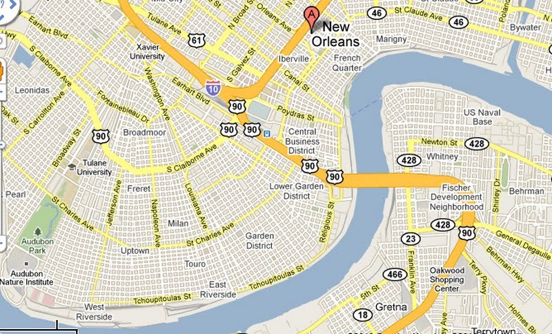
 While by some metrics, the grid is so repetitive that it makes navigation in Chicago more monotonous than it otherwise would be, it certainly makes it less difficult as well. It also facilitates the linearity of the overhead wire network in place in Roscoe Village and numerous other neighborhoods.New Orleans by and large adheres to a grid network as well, but it is hardly as straightforward. One of the main reasons the city has earned the nickname “the Crescent City” is because of the concave bend in the Mississippi River which forms the basis for a continually reconfigured street network, visible in the map below:
 Gridlike it may be, but virtually no one would claim it is an easier city for navigation than Chicago. The network routinely re-orders itself based on the serpentine path of the Mississippi River to the south. Arterials like Claiborne Avenue and St. Charles Avenue parallel the sinuous curves but still operate as the closest thing to a direct route: thus, an unacquainted visitor may think he or she is going straight along these streets—and most cross streets run perpendicular to them—but, if one watches these streets up to the horizon line, they follow a subtle arc. The result encompasses a series of grids that radiate outward from an unarticulated in triangular portions, like the folds of an Asian fan. For navigational purposes, it is virtually impossible to travel north or east as the crow flies, and it is equally difficult to provide directions using the conventional language: instead of “north”, locals will usually say “upriver” or “downriver”.Zooming into a New Orleans grid makes it clear how different it is from Chicago.
 The fundamental geometry is a square, not (as in Chicago’s case) a rectangle or a bisected square. The two long sides of a Chicago rectangle offer the front-door access to the homes and the two short sides provide access to the alleys, garages, and concealed overhead wires. New Orleans’ blocks lack the frontage hierarchy of Chicago; they are more egalitarian, and all four sides of the square typically provide access to homes. If I stare down the length of a block—any block—in New Orleans, this is what I see.
 Very few curb cuts, and no alleys. With the exception of a few select blocks in the oldest neighborhoods—The French Quarter, Warehouse District, and Faubourg Marigny—New Orleans is comparatively lacking in rear access to property the way an alley-dominated city like Chicago is. A further zoom-in to the Uptown neighborhood more clearly reveals the configuration of parcels and property lines within each block, and it’s hard to spot any real pattern.
 I can only begin to speculate exactly why New Orleans has such an irregular block system, but it largely echoes the anything-goes approach toward housing development that New Orleans has long adopted. As I walked along about eight blocks in this generally upper-middle class section of Uptown, I could witness a far greater diversity of housing types than one would expect in a similarly sized neighborhood in Chicago. As the two home photos above demonstrate, it’s interesting to see where homeowners decide to place their cars when they typically lack garages or carriage houses out back. Homes aren’t spaced as close together as they often are in Chicago, so some people squeeze a driveway to the side of the lot.
 Others simply convert their modest front yards to parking spaces:
 Still others preserve the fringe of greenery and settle for parking in the street.
 My investigation as to why New Orleans lacks alleys has figuratively backed me into dead-end one—I can’t find any real answers. But I can guess. Unlike Chicago, in which large tracts were platted and developed with parcels of equal size and housing catering largely to a single economic group, New Orleans’ neighborhoods are a pastiche of irregular lot sizes, homes of widely variable scale and quality, and a seemingly arbitrary mix of uses. The result is—and has always been—that the wealthy and poor more frequently live cheek-by-jowl than in most other American cities. (It could also explain why New Orleans appears to be among the less broadly segregated cities in terms of housing and race.) Many wealthy old families from Uptown wanted their slaves (ahem—servants) to live in close proximity, if not on the premises. Instead of an alley and a garage, the back sides of many homes feature a smaller, semi-detached unit that once served slaves’ quarters. The resulting arrangement of parcels in blocks makes it nearly impossible to draw straight lines across parcel boundaries in New Orleans, and particularly hard to limn a dedicated utility easement behind the properties. The agency installing the poles and wires would have to zigzag out of different parcel lines in order to furnish an electric network in the back yards of people’s houses. Thus, the city’s leadership decided long ago to install virtually all of its electric poles in the only place where straight lines where relatively feasible—in the front, right along the sidewalk.New Orleans faces a twofold dilemma, or four-fold, since all dilemmas have a duality to them. It would be wise to bury the cables to protect them from the strong winds of hurricanes, but then they’d be that much more vulnerable to inundation from floods. It would be lovely to conceal them in the alleys like Chicago does, but by and large it does not have alleys. The City most likely can never aspire to remove the overhead clutter in most of the old urban neighborhoods. How, then, can it come to terms with the mass of exposed infrastructure that comprises a typical street scene? The answer is simple: foster a culture around it that nullifies the idea that it is ugly, messy, or archaic. Celebrate it.In the third and final section, I will focus on the most cost effective solutions for dealing with the visual pollution of infrastructure, using New Orleans as a model and revealing that it has far less of a hurdle to jump than it may initially seem.
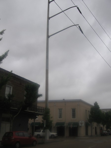
Low density and vast distances of sparse population have fostered a North American landscape in which much of the infrastructure remains supra-structure. Unlike much of urban Western Europe, most American and Canadian cities are pierced with wires hoisted above the sidewalks by either wood poles or, in more exurban areas, by steel pylons. Though overhead transmission through wires or aerial cables remains the least expensive means of conveying electricity, it has increasingly morphed into a form of visual pollution among the collectively conscious. Thus, many large European cities long ago resorted to undergrounding the wires in order to limit the clutter at the horizon line, while also protecting transmission from interruptions caused by snapped wires, induced by a fallen tree or strong winds. Conversely, metropolitan America is filled with these wires; in most of the country, the cost for undergrounding a few wires outweighs the aesthetic benefit.Exceptions to this trans-Atlantic dichotomy do exist—in the US, the most prominent parts of downtowns have underground overhead wires, as do the more recently built residential subdivisions over the past thirty years. Cultural attitudes here clearly seem headed in the same direction as Europe, since nearly all developers in suburban areas where the majority of new housing is built bury the cables for a residential subdivision in order to make their product more marketable (and then of course pass that cost on to the consumer). But nearly all of the “inner city” of metropolitan America—with housing built from the late 1800s until about 1975, as well non-commercial districts of suburbia—still plays host to a variety of methods for overhead electric transmission. To the average observer, overhead cables may seem old-fashioned or less advanced, particularly since they are less prevalent in more contemporary housing developments. But they are not necessarily a technical improvement in every regard: while overhead wires are more susceptible to damage and power outages from wind and falling debris, underground cables are vulnerable to water intrusion or disturbances through uprooted trees. Although power failures with overhead wires are more frequent, underground outages are often longer, more costly to repair, and more difficult to locate. Besides, all transmissions both above and below ground originate at substations and power plants and are therefore never fully undergrounded.I’ve pondered this predicament before, after encountering an unlikely power pole in an overlooked spot on Vanderbilt University’s campus in Nashville. The final argument on above ground versus buried cables nearly always hinges on aesthetics, and most people think a landscape looks better without a series of black, parallel horizontal strips, these viscera that nourish modernity. But who’s left to defend the overhead power line? If a coterie of classic infrastructure-lovers were to band together, what would be the epicenter of their crusade? A good place to look might be New Orleans. No city in the United States that I’m aware of is as “unburied” as the Crescent City. Those cables are everywhere. Granted, it appears that the core of the CBD, between Canal and Poydras Streets, has been undergrounded. Parts of the French Quarter and Warehouse District also have relatively few conspicuous cables. But at the portion of the Warehouse District closest to the waterfront, directly abutting the Morial Convention Center, the power poles are enormous. The photo above barely does it justice, but perhaps these below help.
 It contributes a dramatic conflict with the evenly spaced palm trees along Convention Center Boulevard.
 But it’s far more extreme in the residential neighborhoods outside of the CBD, such as this typical intersection in the Faubourg Marigny:
 In the second part of this post, I’ll explore the broader cultural influences on the New Orleans street grid and the placement of its power lines, as well as the psychological implications for undergrounding in a city with the ground upon which it rests is distinctly fragile. Stay tuned; you might find yourself involuntarily ducking.
If you've tuned in the past few days, I've been gradually tweaking the appearance of the blog to give it a bit more personality. This announcement serves as an indicator that I'm finish making these adjustments for now. No doubt I'll alter the appearance again in the future, but too frequent appearance changes only serve to erode the identity. So, this is all for now.
As I approach my tenth month with this blog, I again want to thank the followers, commentors, and general supporters--thanks for helping me stay alive with fresh posts, even as my own workload has grown a great deal. Keep it up, and I intend to keep the dialogue going for many moons.







 Posts
Posts


