Showing posts with label Pennsylvania. Show all posts

Thursday, May 22, 2014

Forbidden feet.

Travel any reasonable distance in this country, across multiple political boundaries, and you will inevitably discover a variety practices in handling traffic.  We see it everywhere: speed limit differences, right turns on red (or not), the size and generosity of the turn radius at an intersection, the style and design (or even the very existence) of pedestrian amenities. Though it may be a bit hyperbolic to assert that these idiosyncratic distinctions arise from the constituents applying representative democracy to get the system they desire (within the bounds of federally mandated core standards, that is), it isn’t far from the truth either.  Some states have developed their own characteristic strategies: the Michigan Left that I wrote about a few months ago has earned its significant detractors, but enough traffic engineers recognize its merits that other states have started adopting it.  (They still call it a Michigan Left.)  And everyone on the East Coast knows New Jersey’s penchant for the jughandle style of “left” turns, which also has apparently generated enough backlash to prompt injunctive legislation.


But one state has managed to surprise me with its dogged tendency to feature a particular sign—something I have only seen on extremely rare occasions elsewhere, but in this state the sign is commonplace.


Even amidst the dusky, grainy quality of the photo, it is obvious what this sign is trying to convey: no pedestrians allowed here.  Granted, it’s not an area that most would consider a pedestrian paradise: a post-war suburb to a large metropolitan area, in which big-box chains, strip malls, and sizable parking lots flank both sides of a six-lane highway.  Again, the twilight haze might obscure the clarity of the photo, but not enough to point out the obvious.


These signs are not along a limit access highway, an environment that disallows pedestrians through the vast majority of the country.  No, this is an area with plenty of stop lights, curb cuts, and choke points for vehicular traffic.  It’s not an attractive, desirable, or particularly safe area for walkers, but must they be forbidden?  Is it perhaps an isolated instance—a particularly hazardous location in which the sign emerges out of a genuine public interest to inhibit those without motors?


No, these signs are everywhere.  Here’s another intersection a half mile down the road.


Granted, it’s probably a horrible intersection to traverse by foot.  But to forbid it altogether?  Where is this?!  The lighter sky helps clarify, while the concrete “Jersey barrier” separating the directions of traffic flow might offer a hint as to what state this is.  But no, this isn’t New Jersey.


It’s a larger and even more populous state: the Commonwealth of Pennsylvania.  I’m not as well-traveled as some people out there, particularly when it comes to the western half of the US, but I have still never seen a state where “no pedestrian” signs are as prolific.  I frankly can’t recall seeing them anywhere in most states except along expressways.  But they’re just a part of the roadside landscape in PA—in exurbs, rural areas, or major suburban thoroughfares like this one.


I’d be shocked if local police enforce this regulation outside of places where pedestrians typically are forbidden—i.e., legitimate limited access highways.  While it is unfair to form flattering or degrading inferences about an entire state from something as petty as a roadside sign, it’s hard not to wonder what elicited this sign in a state like Pennsylvania, where the settlements, the housing stock, and the roads largely existed before the automobile.  To this day, most Pennsylvania cities and towns—particularly those in the eastern half of the state, where this photo comes from—stand upon a tightly wrought grid with narrow streets, tiny parcels, small setbacks from the sidewalks and an overwhelmingly walkable character.  The interstices between towns might be filled with conventional suburbanization, but the old towns remain quite compact.  This pattern contrasts sharply with a state such as Nevada, where virtually all inhabited areas owe their layout to the ubiquity of the car.  Since around 1970, Pennsylvania has also remained one of the slowest-growing states in the country; population growth in the 2000s was less than 5%.  Thus, Pennsylvania can claim many more intact pre-automobile communities than most states.  And its largest cities, Pittsburgh and Philadelphia, have public transportation systems that, at least by American standards, are fairly robust.


The Keystone State should boast better-than-average pedestrianism, and—for the most part—it probably does.  But somehow, among its successive legislatures, this red, white and black sign slipped into the inventory for various municipal traffic engineers, and in quite a few places they have deployed it with abandon.  My hope for those Pennsylvanians who lack the option or ability to drive is that all police offers turn a blind eye to this regulation.  While the photos above don’t depict a particularly walkable environment (sidewalks are sparse), how is anyone supposed to respond to a scene like this?


The municipality’s public works department has paved along the sidewalk easement, but then it restricts people from walking through the installation of this sign.  It might not yet be dusk, but it’s close enough to the twilight zone.

Thursday, October 31, 2013

Not a fork in the road as much as a spoon.

While it’s easy to derisively brand American suburbia as homogenous and essentially unchanging since it emerged as the preferred settlement pattern for the majority of Americans fifty years ago, we hardly need an intense study to see how much they’ve evolved since the postwar housing boom that began in the late 1940s.  In fact, this “study” glosses over it about as superficially as you can.  But it gets the point across, and it provides the backdrop for an interesting glimpse at what innovations (if that’s the right word) we typically see today.


Go back in history and take a look at the street pattern from subdivisions that sprouted across the purlieus of major metros in the 1950s and early 1960s—about the same time that the Federal Aid Highway Act of 1956 galvanized construction of limited-access expressways through the hearts of medium and large American cities.  By the time President Eisenhower authorized the Federal Interstate Highway System, this segment of Levittown, PA (outside Philadelphia) had already enjoyed several consecutive years of astronomical growth:
 
By today’s standards, Levittown’s homes are modestly sized, the lots small enough to force the homes close together, and the garages/driveways barely accommodate two cars.


But they still represent a remarkable achievement in enabling homeownership to an emergent middle-class that had never enjoyed such a luxury in the past, particularly when the crippling Great Depression brought virtually all housing construction (and ensuing growth in independent households) to a screeching halt.  Average people could afford these homes.


Now let’s do the time warp again thirty years more, by veering about 10 miles closer to central Philly.  Witness the change in the layout of the streets:


While everything contained in this Google Map rests within the municipal boundaries of Philadelphia (unlike anything from the previous Levittown map), the most appropriate description of the neighborhoods outlined here is “transitional”.  The street configurations to the west of the large, bisecting Pennypack Creek Park still mostly abide by the conventional street grid that Philadelphia and most American cities used as the basis for neighborhood design until around World War II.  However, the east side of Pennypack begins to display a mix of conventional grids along with the same carefully ordered curvilinear streets that dominate Levittown further to the north.  Housing developers after World War II, at the onset of the baby boom, began experimenting with street designs that boldly defied the four-way stop and quadrilateral.  These new subdivisions meandered and undulated, continuing uninterrupted without any intersections for much longer intervals than any grid would allow.  The William Levitts of the era gambled by speculating that Middle America would buy into sinuous streets that, though potentially more confusing and less suitable for navigation, helped break the visual monotony of a street that stretched to the horizon line.  Curvilinear streets seemed to work well in the prestigious pioneering streetcar suburbs designed by Frederick Law Olmsted, such as Riverside, Illinois (outside Chicago) or Shaker Heights, Ohio (outside Cleveland).  Why not export this typology to the middle classes?


The gamble paid off in spades, and first-time homeowners embraced the street design that all three of the major Levittowns employed.  Before long, virtually every major metro witnessed the development of communities that followed the Levittown model, with most proliferating at about the same time that the central cities endured the cataclysm of interstate highway construction right through the central neighborhoods.  Thus, it should come as no surprise that these 1950s suburbs nearly always stretch in close proximity to either their city’s major interstate highway, the circular beltways (with three-digit numbers instead of two) or both.


But this elegantly winding braid of streets still generally lacks something we associate with today’s suburbia: complete automobile dependency.  It might not be easy or particularly desirable, but usually Levittowns are still tightly organized enough that it is possible to walk to a few destinations.  Purely hierarchical street patterns—in which one “trunk” road provides access to “branches” and then still smaller sprouts—did not catch on until later, meaning we have to go back to the future (and much, much further out from the city center) to see the sort of development patterns that emerged in the late 1960s and 70s.  The map of upper Bucks County (north of Levittown) proves this.


By the time the overwhelming majority of households had at least one car, it became de rigueur for developers to build according to these expansive street configurations, resulting in subdivisions that emphasized homeowners’ privacy at the expense of any real walkability.  With homes spaced much further apart, yards were larger, and no amenities stood conveniently within walking distance, even back on the collector or arterial that provided access to the subdivisions.  Nobody who bought into these developments gave any consideration that they would get anywhere except by car. Quite a few developments built during the 60s and 70s didn’t have sidewalks.


Housing from this time period isn’t as abundant as are the examples from the 1950s, because fewer households were organizing into families.  A moderate baby bust followed the boom.  Interestingly, home sizes grew even as the birth rate plunged; thus, individual households had more space to their own than any time in history—both inside and outside the house. Demand for shared green space reached a nadir.  Public parks in these regions are particularly scarce, since private yards typically sufficed.  The few parks in Upper Bucks County must devote a significant amount of space to parking lots, because they are inevitably unreachable by foot.


It was this time period that the cul-de-sac evolved from a suburban novelty to a sine qua non in subdivision development; families soon specifically sought them out.  The early 1960s developments often didn’t even bother with the circular patch of pavement that allowed vehicles to turn around; the roads just terminated in dead ends, particularly when these new suburbs were pushing into unincorporated areas well beyond the inner-ring suburbs.  Most municipalities eventually required roads to end in cul-de-sacs.  While the curvilinear configuration of the 1950s remained popular, by this point many of the streets in a subdivision terminated in a court.  The lack of a thruway discouraged all cars except for those belonging to people who lived on that cul-de-sac, dramatically lowering traffic volume, increasing privacy and giving the suburban subdivision a quiet, low-density settlement pattern that almost resembled rural living. 


I’m not sure when the next subtle generation in subdivision design truly emerged, but it would probably correlate to the late 1970s and early 1980s, when the now-adult Baby Boomers began starting their own families—the echo boom.  Household formation picked up pace, and these young families generally sought new construction just as their parents had.  While some of the new developments took on an expansive form—particularly the luxury ones or those where land was cheap and abundant—quite a few homebuilders tightened the design.  In many cases, average lot sizes retreated slightly, even while square footage to the homes continued a steady growth.  Perhaps recognizing that they had renounced too many neighborhood essentials (or perhaps because more municipalities began mandating them), the developers of suburbs from the 1980s and onward regularly featured amenities such as storm sewers, curbs, and sidewalks (at least on one side of the street).  As a compensation for the slightly smaller yards, these subdivisions (particularly the larger ones) would often include some shared open space in the form of greenery around a decorative retention pond, a community clubhouse, or a soccer field.


Why did this happen? Why did subdivisions return to a slightly higher, more urban density than the decades prior?  My own suspicion is that some of it was prescriptive: through ordinances, municipalities started requiring culs-de-sac instead of dead ends, or storm sewers instead of drainage ditches, which drove up development costs.  Also, formerly unincorporated lands began incorporating and immediately raising the minimum standards for subdivision design.  Developers, in turn, couldn’t necessarily pass these imposed costs directly to the consumer, so instead they found a trade-off with smaller lot sizes, squeezing more homes into a newly platted piece of land.  The result looks something like the quintessential 1980s/90s suburb below:


If this photo looks unusually flat for something in Pennsylvania, that’s because it isn’t Pennsylvania.  The subdivision pictured above is in the outskirts of Baton Rouge, Louisiana.  While such a shift in location may seem eccentric or even unexplainable, Baton Rouge offers much more abundant examples of the 1980s subdivisions, having grown considerably at a time when the more mature metro of Philadelphia was fairly stagnant.


This subdivision also demonstrates another, subtler evolution in street design: the 90-degree cul-de-sac.  Notice the shift in the street from the photo below, as well as the parallel sidewalk.


The buffer strip between the sidewalk and the street seems a bit larger than normal, but other than that, nothing is likely to catch the eye as out of the ordinary.  But then, upon entering the bend in the road, the sidewalk takes a more generous cut into people’s front yards, veering strangely close to their front porches. 


Why would they have done this?  It almost appears to me that authorities approved the site plan without thoroughly vetting it.  While there’s nothing wrong per say about having a sidewalk so close to a house, it’s also hard to see why the average buyer would prefer it to a parcel where the sidewalk is much closer to the street.


Elsewhere, in a similar neighborhood down the road, one can witness another insertion of the cul-de-sac into a 90-degree-turn.  Though the homes are more modest, the design of the sidewalk seems a bit more conventional, and, as a result, more effective.


But look at the grassy island in the middle.  The lawn is poorly maintained, and the absence of any other landscaping makes it seem like an afterthought—like some sort of padding.


In neither of the two above examples is the execution as effective as it should be, which makes me suspect that the developers really didn’t know what they were doing.  Or they didn’t care.  It’s not a tough concept, though if these worm’s-eye photographs don’t convey it, this bird’s-eye Google Map should, taken from a subdivision of similar design in the same part of town.


Notice how the 90-degree bends stretch into curvy culs-de-sac?  This road design is a shrewd method to make a little more money by cramming an additional parcel or two into the same space.  If the road were to employ a conventional l-shaped bend, the lots that directly front the bend would be even more strictly wedge shaped, to the point that the street frontage wouldn’t be wide enough to allow individual driveways.  Or, one house would claim an enormous side yard from the land that is completely unreachable by a driveway.  With a gentle arc in its place, each house gets more or less the same linear footage as access to the street, and the surveyors who put together the original plat could fit in another parcel or two.  And a more conscientious developer could transform grassy patch in the center of the cul-de-sac into an attractive, verdant amenity.


There’s nothing subversive or unethical about this design; it simply demonstrates that, particularly for moderate or middle-income households, developers have learned they can slice away at some of the yard size.  The homes featured in the photos and map above all come from Gardere, a lower and moderate-income area on the otherwise affluent south side of Baton Rouge.  My suspicion is that these subdivisions exist through some form of Low-Income Housing Tax Credits: they’re newer, in better condition, and bear some of the “neo-traditional” design features that federal housing programs love to employ.  Because the average buyer for these properties doesn’t have the money to be choosy, developers can take huge liberties, and they don’t necessarily worry about details like attractively landscaped common area or well-designed sidewalks.  And, in the grand evolutionary arc (pun fully intended) of American settlements, this represents one more design strategy pushing us further from the look and feel of the original Levittown.  Suburban developments are neither uniform nor unchanging.  I’m not confident that the conventional grid will ever become the standard again, even though New Urbanist advocates have successfully implemented it in specialized niche developments throughout the country.  (After all, does anyone openly claim to be a New Urbanist anymore?)  But I absolutely trust that culs-de-sac and street curves have a long way to grow before the design calcifies.  And it probably never will.  The evolution continues.

Wednesday, March 6, 2013

BOOK REVIEW: What Killed Downtown?


My latest is a first for me as a blogger: a book review.  The full-length review is now available at Urbanophile and should be accessible soon via other online outlets; I will update this blog post accordingly.  The book, Michael Tolle’s Who Killed Downtown? Norristown, Pennsylvania from Main Street to the Malls distinguishes itself through its unflagging focus on the six-block commercial center of Norristown, an older suburban community outside Philadelphia of approximately 30,000 people, of which most people in the country (let along in Pennsylvania) probably know little.  Although it emerged as a distant Philadelphia outpost in the early 19th century, and it remains the seat of government for Montgomery County, the Borough of Norristown is no longer a major commercial or employment center.

Most of the factors that influenced Main Street Norristown’s precipitous decline from its 1950 are predictable: overwhelming population growth to the south, the increasing dominance of the car along the city’s pedestrian-scaled street, the construction of limited access highways that threaded their way near Norristown but outside its boundaries; the proliferation of suburban shopping centers with free, ample parking for those cars.  Today, Norristown isn’t necessarily impoverished, but its income levels are significantly lower than all the communities that surround it, and far below the average for Montgomery County, one of the 100 wealthiest counties in the country.  And Norristown’s main street is a wraith: bereft of any major retail establishments, and pockmarked with parking lots where proud commercial buildings once stood.


With such an unwavering focus on six commercial blocks across 250 pages, how does Tolle distinguish his chronicle of main street decline from dozens of other similar books?  His biggest achievement, as far as I’m concerned, is a shrewd avoidance of socioeconomic variables to demonstrate his point.  He rarely touches upon reports for the US Census Bureau or the Bureau of Labor Statistics.  Instead, he integrates his study with numerous references to the City Directory of Businesses (comparing the change in industries every few years), articles from the Norristown Times Herald, advertisements (including misspellings and solecisms), and, in the later years, eyewitness accounts.  The worm’s-eye-view is unapologetically subjective, but this fundamentally anthropological approach lends the entire study a human interest that compensates for Tolle’s relentless fixation on storefront details.

I have my doubts that such a book will ever win much of an audience outside of Norristown and its purlieus, but if that’s enough for Tolle, I can certainly commend his refreshing approach to well-worn territory.  Comments as always are welcome; I will do my best to respond on this website, Urbanophile, or other outlets as they materialize.

Thursday, February 28, 2013

Peddling politics to pick your poison.

If the free market could ever assume a bodily form, it would have to be a contortionist.  One of the wonders of our federalist system is how deftly and shrewdly private businesses navigate around ordinances and statutes.  While this is obvious when articulated in print, the real-word incarnations are often subtle.  These maneuverings manifest themselves a bit more when spatial boundaries define them, and even more when the political jurisdictions that the boundaries encompass are particularly small.  The northeastern United States is often much more interesting in this regard, not only because practically everything is incorporated, but because the jurisdictions are tiny in comparison to anything we might see out west.  Over the course of four hours, you can cross four states in New England.  And the home rule culture is often so powerful that one town may subject a certain industry to certain regulations that the next town—just two miles away—completely ignores.

Nothing I have witnessed recently better demonstrates this culture than a trip to the town of Morrisville, Pennsylvania, nestled lazily along the Delaware River.  Crossing the river from the east on State Road 32 (known in Morrisville as Bridge Street), the modest, low-slung commercial center greets the motorist almost immediately.


The sunset vista shrouds almost all of the details, but the basic massing of the main street at the horizon line shows up clearly enough.  Here’s a crisper view after pivoting the other direction.


The bridge over the Delaware River would sprawl just a wee bit further off the edge of the frame on the right.  Sunlight may have been fading, but the signs on all the storefronts show up clearly enough.  Here’s a closer, sharper view of the well-lit storefront house in the middle of the above photo.


Looks like a smoke shop.  The first intersecting street, Delmorr Avenue also features another low-rise storefront:


A fusion restaurant of some sort to the right, but what’s to the left?


A cheap cigarette outlet.  And, on the other side of Delmorr Avenue where it intersects with Bridge Street…


A tobacco shop.  Incidentally, Smokin’ Joe’s is the same storefront featured in that silhouetted first photo—the small white sign on the far left of pic.


Notice a trend here?  Morrisville’s entire commercial spine is only three blocks long, so it doesn’t take much to absorb the full perspective, even when proceeding by foot.  Here are some additional storefronts on the opposite side of the street:


More happy smokers.  Continuing westward, the next block hosts a building that is conspicuously new-looking.  Perhaps it’s infill development; if so, it’s pretty smart and blends in almost seamlessly.


It’s also the only major building I’ve encountered in which nicotine doesn’t figure heavily.  My side of the main street is a different story:


And just two or three doors down:


A smoke shop that has been open for over half a decade—an institution!  Finally, as Bridge Street intersects with Pennsylvania Avenue, the old-fashioned commercial street comes to an end, giving way to a familiar strip mall at the next block.


It’s not much to look at even in broad daylight, but particularly hard for me to capture as twilight sets in.  But I just managed to capture the sign for the middle storefront:


You better believe it’s a cigarette shop.  By my count that makes an earth-shattering seven smoke shops across what is essentially a three-block main street and its affiliated little strip centers.  Unreal.  When I first made this observation—which was probably the second time I passed through Morrisville, I just assumed it was a drab, hardscrabble little blue-collar down, in which 95% of the denizens placate themselves through a steady diet of Yuengling and nicotine.  But then I realized I wasn’t being fair; I wasn’t placing Morrisville in its full political context.


By the same token, I haven’t been fair to readers of this article since that introductory paragraph: Morrisville indeed sits along the Delaware River, but the river forms the border between Pennsylvania and New Jersey.  (Folks from the Mid-Atlantic would probably know this, but it isn’t common knowledge to the rest of the country.)  This is critical because directly across the Delaware River from Morrisville is Trenton, New Jersey, the state capital and a major population center.  But what does that have to do with Morrisville’s predilection for smokes?


I didn’t even have to do the research.  Of course: New Jersey’s cigarette taxes are significantly higher.  A quick view of the 2013 rates provided by the Federation of Tax Administrators confirms it: while Pennsylvania’s tax rate of 160 cents per pack isn’t exactly low (22nd in the nation), it’s still over a dollar saved from Jersey’s 270 per pack (6th in the nation).  And Pennsylvania shares a large border with New York (1st in the nation, with a whopping 435-cent tax).  I’m sure the border towns up by the Empire State are glutted with tobacco shops on the Pennsylvania side as well.


It’s obvious now that these small business owners saw an opportunity with the leasable space in downtown Morrisville and ran with it.  When New Jerseyans make that quick trip across the bridge, they enjoy a smorgasbord of smoke shops from which to choose, and obviously enough of them cross here that seven proprietors can support themselves despite being a stone’s throw from one another.  The cigarette industry contorts itself, over-representing one side of the river where the prices are lower and, quite logically, demand is much greater.  I alluded to this once in the past in New England, where New Hampshire “front loads” all the sins that it doesn’t regulate heavily in a strip mall right near its border (fireworks, pornography, pawn shops), whereas Massachusetts outlaws or seriously regulates these enterprises.  The Bay Staters just have to head up to the state whose motto is “Live Free or Die” to sample some forbidden fruit.


Cigarettes are without a doubt the most high-profile sin tax, but the situation in Morrisville leads one to question whether the tax can pass a tipping point, when it ceases to raise as much revenue as it would if the rates were more competitive with the neighbors.  After all, New Jersey’s a small state, and even folks living along the eastern shore still only have at most a 70-minute drive to the border, so they could cross the river periodically, stock up in Pennsylvania, and save mucho dinero.  The tax differentials may level out within the Keystone State, because other parts of Pennsylvania share a border with West Virginia, where it only costs 55 cents a pack.  What the state loses in the southwest finds compensation through what it gains along the Delaware River.  The give–and-take between two adjacent states involves too many laws, goods and services to determine which one ultimately wins the most revenue, but Morrisville comes out on top in terms of winning a surefire tenant to fill commercial space on the main street, resulting in a town with a fairly low retail vacancy rate, albeit one that is largely tenanted by a carcinogen.  Now if only parents could get as worked up about smoke shops as they do about adult video stores and tattoo parlors…

Monday, January 28, 2013

Reviving with the wave of a wizard’s wand.


Earlier this past fall, I featured the accomplishments of the City of Kokomo, Indiana in reinventing itself over the past few years, after two decades of rust-belt, deindustrialized stagnancy.  Civic leadership successfully elicited a certain degree of buy-in among its constituent, all toward sundry capital improvements, the likes of which most similarly sized cities still only retain on their wish lists.  The results are conspicuous.  Kokomo has made formidable strides in infrastructural improvements, mass transit, downtown revitalization, park expansion, public art, and an ambitious International Baccalaureate exchange program at the public schools—all while maintaining a balanced city budget.  According to some of the city’s cheerleaders for these expenditures, the overall ethos driving the city is far more upbeat than it has been in years, despite the fact that, as recently as 2008, Forbes listed the city as one of America’s fastest dying towns.  Perhaps that article served as a wake-up call, because I’d be hard-pressed to imagine that recent visitors to Kokomo’s downtown would ever see the city as dying—certainly in comparison to dozens of other similarly sized cities across New York, Pennsylvania, New Jersey, Ohio, Michigan, and Indiana that show little to no evidence of revitalization at work.

The combined impact of these upgrades is inspiring.  But none of them (with the possible exception of the International Baccalaureate exchange) is particularly groundbreaking.  Virtually every city these days has attempted revitalization through a certain combination of sculptures/murals, streetscape improvements, heritage pedestrian/bike trails, new parks, et cetera et cetera.  These initiatives seem to come from a City Planning 101 playbook.  It’s as though cities have completely taken the bait from the many national assessment tools created by various urban advocacy nonprofits in order to gauge quality of life.  At the same time, the advisory committees that operate these organizations (and thus create their highly subjective definitions of “quality of life”) consist overwhelmingly of city planners and their lobbyist allies, cajoling municipalities to eat out of their hands in a manner that smacks of self-aggrandizement.  To put it more simply, cities like Kokomo strive for (and ultimately invest in) bike lanes, mixed-use trails, or omnipresent bike racks, all in order to achieve and flaunt that bronze rating from the League of Bicyclists, which in turn wins free publicity for itself in the process.  I cynically alluded to this practice in Baton Rouge a few years ago. 

I’m not trying to undermine or belittle these practices, nor do I mean to pick on the League of American Bicyclists’ worthy mission.  And the initiative that Kokomo has shown these past few years is commendable—and the city has usually implemented these upgrades far more smartly than one might see in a larger city like Indianapolis.  But the standards for what constitutes a “livable” city seem to grow more uniform and homogenized with each passing year that these standard-bearers of good urbanism grow in influence.  The remedy for economic malaise increasingly seems to be the same everywhere, like a doctor who prescribes cod liver oil for both arthritis and malaria.  So it is with no small fanfare that I declare how happy I am that a local entrepreneur in Kokomo has marched alongside the corps of revitalizers, but to his own beat.


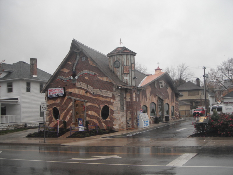
This whimsical structure, known as Storybook Express, opened in 2012 at a long-vacant site at Sycamore Street and Apperson Way, just a few blocks from the Howard County Courthouse.  Although it’s a convenience store, the unconventional, fairytale appearance has prompted locals to christen it the “Harry Potter house”.  Even from a distance, the building’s densely ornamented façade and off-kilter massing and brickwork help distinguish it.
But a closer look reveals the devil-may-care insertion of neglected or discarded antiques into the masonry:
Notice the metal pig’s derriere rammed into the wood just above the transom window.

More often than not, eye-catching façades such as these are a total bust when viewed from less prominent angles.  The designer puts all the mojo in the front view.  But Storybook Express includes just as much eccentric detail on the backside as well:
An old church inscription, a car’s suspension coil, antiquated plumbing, and other unidentifiable bric-a-brac enhance the façade’s visual interest.  Even the relatively conventional brick wall, used to elevate and protect the convenience store’s HVAC equipment, deliberately employs an excessive amount of mortar to enhance the multi-dimensionality.  Look how it oozes from between the bricks.
The western wall is equally whimsical and boasts the added benefit of a drive-thru window, a relatively uncommon feature in convenience stores.
But I have to confess that my favorite detail is the parking lot, mainly because it would be so easy to settle for drab convention.  But the brains behind Storybook Express allowed the whimsy to permeate the entire design.  The retaining wall adheres to the same pastiche as the masonry:
And it takes real chutzpah to employ an unconventional striping for a parking lot, a practice that in many cities would require special approval:

Storybook Express would easily qualify as a great roadside curiosity even if it sat in isolation.  But it is the culminating achievement of Fortune Management, a local real estate development firm with holdings throughout the city, including a few other developments in a similar vernacular.  I found one of these other curiosities on my own, at Markland Avenue and Calumet Street.
This structure, dating from 1999, hosts a nail salon.
Like Storybook Express, it applies the fanciful masonry mixed with assorted folderol on all four sides.
Digging back a bit further in time, Fortune Management adapted some brownfield sites into office space.  The property at Markland and Washington previously hosted a transmission repair shop that had clearly seen better days:
In 1995, Fortune Management transformed it into this:
And the company pioneered this aesthetic with a Shell Station at Sycamore and Washington, way back in 1987.  Before the redevelopment, it looked like this:
And afterwards:
These earlier efforts may appear less ostentatious than the convenience store downtown, but they ascribe to the same spirit in their design.

A recent interview with Fortune Management’s president, Scott Pitcher, helped shed some light on his rationale.  The firm has purchased and renovated over 50 properties in the Kokomo area since its 1982 founding.  Pitcher’s goal, even for the less fanciful redevelopments, has been to employ high-quality materials from the same time period as the original structure.  More often than not, Fortune Management has rescued materials from other buildings under demolition in Kokomo other various Indiana.  Not surprisingly, the Storybook Express convenience store featured in the first photos series was new construction on a lot that the company had held in its portfolio for years.  Although not a renovation, it nonetheless consists primarily of repurposed material, while the customized roof exclusively employed Kokomo craftspeople.
The ostensible “Harry Potter” references are a throwback to a legitimate Storybook architectural style in vogue during the 1920s in Hollywood.  Despite the recession, the time finally seemed right a few years ago for Pitcher to begin developing Storybook Express in order to capitalize on the other revitalization efforts that had taken place in downtown Kokomo.  He partnered with a local entrepreneur who was interested in opening a convenience store at the site, and though it was inevitable that it would require parking, the structure still engages Sycamore Street with a very small setback, allowing the structure to accommodate vehicles and pedestrians in nearly equal measure, as the somewhat blurry photo below still demonstrates:

What motivated Pitcher and his team to try this style?  These sundry developments seem inspired by both a love of vintage Hollywood movie sets as well as the plundering of small-town antique shops, though they have also achieved statewide recognition for persistent use of local material, winning an Indiana Green Business Award in 2010.  At the same time, I see little evidence in Pitcher’s work that he was striving for broader recognition in the architectural or artistic community.  He wasn’t trying to impress the New York art scene; he built this way because he felt like it.  I shy away from the dubious label of “folk art” because it carries with it a whiff of condescension—that folk artists are uncouth autodidacts who remain ignorant of the preferred aesthetic standards and mores of the time.  Pitcher knows exactly what he’s trying to achieve, but Storybook Express and its cousins have flourished despite being untethered to any broader cultural barometer.  For me, the DIY framework by which these buildings came into being can’t help but recall the work of Philadelphia artist Isaiah Zagar, who for decades has charmed his neighborhood through colorful mosaics and found-object installations superimposed onto various buildings.  The vast majority of Zagar’s corpus remains concentrated along South Street and the adjacent blocks, such as the examples below:

Obviously Scott Pitcher and Isaiah Zagar aren’t entirely kindred spirits: Zagar self-identifies as an artist and Pitcher is first and foremost a developer.  And while Zagar’s most widely recognized artistic output polka-dots the various workaday streets of South Philly, his work also sits in the permanent collections of art institutions both inside and outside of metro Philadelphia.  Nonetheless, Zagar has admitted his affinity with folk and visionary artists from across the globe, and he doesn’t hesitate to identify as a “vernacular artist” because the majority of his corpus thrives from decades of embedding himself in the community he loves, rather than responding exclusively to the dictates of specific commissions.  Pitcher, meanwhile, has indicated that any new Storybook project will likely take place far from downtown Kokomo, since he feels a similar edifice will only dilute the impact of Storybook Express (which, not surprisingly, has proven a resounding success as a convenience store).  He hopes to forge his next venture in another smaller Indiana downtown, or perhaps even something in Indianapolis.

What Zagar and Pitcher clearly share is an aesthetic vision divorced from an overt context.  Zagar could have filled his murals with references to Jim Croce or Marian Anderson or Mario Lanza, if he wanted to draw from South Philly’s heritage of vocal musicians.  He could have partnered with a nonprofit to engage in a comprehensive beautification campaign through targeted mosaic design and specific locations.  But the visual evidence suggests neither of these.  Nor does Scott Pitcher seem to care if 1920s Hollywood (or Hogwarts) has anything to do with Kokomo, the City of Firsts.  And therein lies the appeal.  Most of Kokomo’s other revitalization initiatives are sincere attempts to jolt the city out of its multi-decade torpor by massaging the dormant creative economy.  Kokomo hopes to retain its population through compelling quality of life amenities.  But when every small city sees bike lanes and murals as the remedy, couldn’t these urban organisms eventually develop immunity to the treatment?  Sometimes individual ingenuity—the entrepreneurs who swim against the current—can offer more long-term regenerative potential than all the social policies a city council can conceive.  Kokomo’s future success will undoubtedly owes a great deal to committed and talented civic leadership, but its distinctiveness may rely heavily upon a playful little building near downtown called Storybook Express.