skip to main |
skip to sidebar
My previous blog post used College Avenue as a launchpad for exploring how Indianapolis had once earned the moniker “Interurban Capital of the World”. College Avenue, heading from downtown northward to Broad Ripple Village and beyond, was one of many routes of this predecessor to today’s light rail that used Indy as a hub. The College Avenue interurban deserves special recognition because a reasonable amount of architecture survives that clearly served the old interurban stops, where passengers would disembark and walk to shops, offices, or housing by foot. In the earlier post I traced some of the most obvious remnants of those old interurban stops, from downtown (Michigan Street) up the vast east-west arterial of 38th Street. Today I will continue northward, through some of the more affluent and stable neighborhoods of the city, which in turn demonstrate the healthiest commercial nodes that owe their beginnings to the College Avenue interurban.
4200 North
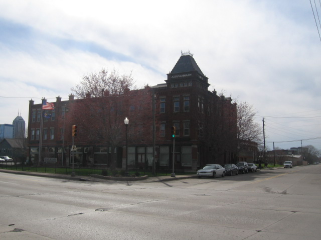
Crossing 38th Street along College Avenue, the passenger would enter the verdant Meridian Kessler neighborhood. College Avenue here serves as a bit of a dividing line between the largely wealthy portion to the west and the far less wealthy east. The commercial presence of the historic interurban has given way to civic uses, such as the relatively pedestrian scaled library in the southwest corner. Freemason Hall to the northwest remains the strongest surviving example of historic architecture, with retail at the ground level; two other corners now consist of parking lots. 


4600 NorthNo doubt much of the architecture that accommodated this interurban stop has faced the wrecking ball, but the low-rise commercial structure on the northeast corner survives. Garuda, the Indonesian restaurant to the far right in the second photo, has apparently faced many permitting barriers but is finally slated to open in mid-April. As the economy improves, the southwest corner offers an excellent redevelopment opportunity in what is essentially an economically healthy area.


4900 North
This may be the first interurban stop in which more than fifty percent of the historic commercial architecture survives. Until recently, it was still an economic laggard in terms of retail desirability, but it has sparked interest in the past few years with some new tenants targeting the generally affluent population living nearby, including a new tasting room for the Upland Brewery, and Recess, a local restaurant. Only the southeast corner seems to have completely faced the bulldozer, hosting a more contemporary structure with parking out front. 


This intersection is worth further recognition, for the evidence that developers have been sniffing around it for quite some time.
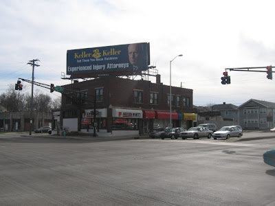
 Part of the northwest corner (the part fronting College Avenue) was sacrificed for a building with parking out front, but now both it and the residences to the north are subject to re-evaluation for a mixed-use, urban infill project, which likely will stimulate further interest and discussion when the economy improves. For those who would like to see the proposal featured in this sign replace the blighted current structure, I encourage you to sign this petition in support of The Uptown. 5200 North By most metrics, this interurban stop offers what most of the others can hope to achieve—a fully functional retail node that often generates a fair amount of foot traffic. Only the southeast corner, home of Sparkle Cleaners, features a setback with parking out front, but the parking is modest and does not radically weaken the character that makes this intersection a pedestrian scaled node. (Granted, the Habig Garden Shop probably does not date from the interurban, but at least it's scaled in accordance with pedestrian traffic.) Most of the storefronts are occupied with local establishments, some of which have been there for decades. This northern portion of the Meridian Kessler neighborhood never went into economic decline, and thus the retail structures have not faced the sort of economic hardship that might otherwise justify their demolition.


5400 NorthThis lively node, just two blocks north of the previous, has captured the character which the developers of The Uptown Indy clearly hope to replicate at other College Avenue intersections. Even the southwest corner, with cars out front of Moe and Johnny’s, still manages to retain the feel of a neighborhood retail node fully approachable by pedestrians. The relative scarcity of off-street parking has not dimmed the popularity of these locations. The northeast corner, home of the grocer Fresh Market, elicited some disappointment to urbanists when this redevelopment took place a few years ago because of the prominently visible parking lot, but the structure remains generally inviting to foot traffic. The biggest disappointment is that the front setback with parking squandered the opportunity for alfresco seating or casual eating that would have enhanced the intersection far more than a parking lot.


5950 NorthApparently the two southern corners of College Avenue’s intersection with Kessler Boulevard East Drive met their demise to more auto-oriented structures, housing a mechanic and veterinary office at this point. Meanwhile, the older structure on the northeast corner still offers parking out front. Thus, this intersection has less pedestrian activity than its two predecessors, but it still houses some local establishments clearly targeting the neighborhood. Had the Broad Ripple Animal Clinic at the southeast corner opened just a few years later when design considerations were more en vogue, it might have faced greater scrutiny by activists in the neighborhood.


6300 NorthIn all likelihood, two of the three corners here at College Avenue, Broad Ripple Avenue, and Westfield Boulevard lost their historic architecture to gas stations and drive-thru banks, while another corner hosts part of the Central Canal and a drugstore. But the one corner that survives (the southeast) comprises the heart of Broad Ripple Village, long the center of Indianapolis pedestrian activity and nightlife, even when downtown Indianapolis rolled up its sidewalks after dark. A century ago, Broad Ripple was a weekend retreat for city dwellers before it was absorbed into the city limits, and it remains a popular leisure destination to this day. The economy has put a bit of a dent in the occupancy levels of some of the storefronts, but this prominent corner recently saw Barley Island Brewhouse sign on to the neighborhood’s famously pricey leases. These pictures hardly capture it (try the Google Streetview instead if you are unfamiliar with area), but the pedestrian scale continues along Broad Ripple Avenue and has solidified the neighborhood as one of the city’s most stable—yet time and again, elsewhere in the city, remonstrators fight developments that employ a density and scale similar to Broad Ripple. (The Uptown Indy development featured earlier has already faced severe hurdles.) Two inert gas stations in the neighborhood should also offer opportunities for urban infill, if the economy improves and the community can buy into the notion that densification will only enhance Broad Ripple’s desirability (and their property values).


6400 NorthA block north, and we’re more or less to the end of the line, or at least to the point where the interurban made frequent, clearly visible stops. Even here, the character seems overwhelmingly auto-oriented and suburban, though a few older structures suggest this intersection’s genesis falls within Broad Ripple’s pedestrian scaled sphere of influence. The American Legion building at the southeast corner clearly derives from a less auto dominated era, yet it has largely sealed itself off from the outside world; the appearance of near abandonment has resulted in a structure that routinely has to fend off graffiti artists. 


Beyond this intersection, the character of College Avenue quickly becomes low-density and suburban, as it enters the verdant, wealthy Meridian Hills and Williams Creek neighborhoods. Broad Ripple represents the culminating point, as far as the historic commercial nodes are concerned. The general trajectory of College Avenue’s interurban stops reveals that both the economic health and condition of the architecture improve as one travels farther away from the city center; this reflects the decentralizing patterns of most American cities over the past century. But in recent years, even the most desolate of College Avenue’s old nodes have attracted increasing public interest; many members of the College Avenue Neighborhood Development Organization have worked together to maintain a Ning site informing the community of further revitalization efforts.But is the reawakened activism for the culture of the College Avenue interurban anything more than second life for a certain aesthetic construct within the built environment, where everything old is new again? Is it any different than the rediscovery of our historic city centers over the past twenty years, or the renewed popularity of tight jeans among hipsters? Time will only tell if the College Avenue corridor undergoes a full-scale revitalization across all the old interurban stops, and even more time will only tell if such a revitalization is sustainable. But it behooves the economic development leaders of the neighborhoods that straddle this historic Indianapolis corridor to ride the current wave of curiosity and nostalgia, which have helped transform some of these intersections into the most attractive incubators for small businesses (particularly local restaurants) in the entire metro. A transit line may serve as a catalyst for further regeneration, but my guess is it will happen regardless of whether College Avenue ever witnesses something like an interurban. These are the strip malls of yesteryear, while strip malls are the retail archetype of yesterday. And in a culture that thrives on perpetual reinvention, yesterday is old hat, while yesteryear is positively vintage.
It’s been some time since I’ve included a post that emphasizes pictures over text, but my goal of one pic-heavy post per month is about to expire for March, so here it goes. This one can’t even claim complete originality: Urban Indy has featured several thoughtful posts on the city’s old streetcar/interurban network, devoting specific attention to the pivotal route along College Avenue and how a rethinking of solid transit—like the old days—could boost the brand and place identity of the Meridian-Kessler neighborhood that the artery partially serves. Urban Indy provided the analysis; I hope to offer the photo accompaniment.Anyone from Indianapolis with more than a passing interest in this blog no doubt knows that the city had once earned the title of “Interurban Capital of the World”. Indiana boasted over 2,400 miles of tracks, 12 of which converged at the Traction Terminal building at the state’s capital. With the exception of Evansville, all major cities in Indiana were connected through the interurban system, and the tracks helped foster the growth of some of the earliest suburbs. [Far greater detail on the interurban’s history in the city is available in the section “Transportation” by Ralph D. Gray, in The Encyclopedia of Indianapolis, Eds. Bodenhammer and Barrows, 1994]Because so many of the suburban growth patterns of the city disproportionally favored the north side of downtown, the College Avenue interurban route—which would begin on the eastern edge of downtown and head northward into the rural purlieus—was undoubtedly among the most prominent. At its peak in the 1910s, the College Avenue route offered the primary means of transport for wealthy citizens in what were then outlying suburbs such as Mapleton, Watson-McCord, Meridian Kessler, Forest Hills, and Broad Ripple. Any heavy construction work on College Avenue most likely reveals the old embedded rails buried under layers of asphalt.The interurban stops helped to spawn architecture that served the passengers at the various stops where they would disembark. Even after seven decades since the interurban’s demise, many vestiges of the interurban-derived architecture survive, with structures that have housed retail, offices, and even some residences. The College Avenue corridor vaguely resembles the suburban communities connected, like beads on a string, through the US 30/Lancaster Avenue corridor that comprise Philadelphia’s famed suburban “Main Line,” though at a different scale. (The biggest difference, of course, is that the Main Line in Philadelphia survives as a commuter rail, and the stops along this track aren’t mere commercial nodes but are actual suburbs, such as Narberth, Haverford, Bryn Mawr, and Villanova.)In Indianapolis, the physical condition of these nodes of activity at the old interurban stops varies greatly; in some cases, demolition has rendered the College Avenue interurban stops almost unrecognizable. Starting from the downtown area and working northward, I hope to show the intersections that most likely comprised “stations” for the College Avenue Interurban, and perhaps the viewers can fill me in on my accuracy. College Avenue runs north and south, and at each prominent intersection, I will offer four photos, starting from the northwest and working clockwise, to end at the southwest. The photo sequence will look more or less like this: Obviously, very complicated. From this point onward, text will be limited. Hopefully the images—derived over the course of several months with multiple cameras and some inappropriate shutter speeds—will foster more than enough discussion and curiosity (and, hopefully, more artful photography than the some of the biggest duds among this series!).400 NorthThe first most likely interurban stop appears where College Avenue intersects Michigan Street. The empty field on the northwest quadrant originally intended to host more condos like the ones visible in the background to the left. This area was rife with development activity before the economic downturn, and will most likely pick up again if the condo market improves.


 1100 NorthI suspect there was at least one other interurban stop between the 400 and 1100 block, most likely at St. Clair Street (the 800 North block), but very little residual architecture survives to suggest it. The area has undergone significant redevelopment in recent years. Thus, I can only push northward to the next most likely interurban stop, at College and 11th Street. The ugly substation no doubt limits the attractiveness of redeveloping the old retail strip on the northeast quadrant.


 1600 NorthThe next major intersection, at 16th Street, separates the largely gentrified Old Northside neighborhood from the gentrifying Herron-Morton Place. Only one of the four corners, at the southwest, shows much evidence of an old structure that likely owes its origins to an interurban stop. This partially dissected cadaver of an edifice will likely survive to enjoy a complete redevelopment in the next few years, if current trends continue. The other three corners may prove a greater challenge, but the current uses demonstrate the intersection’s legacy of depressed real estate.


 1900 NorthThis block would not appear to be a likely streetcar stop, except for the survival of one structure at the southeast corner. 19th Street is not a prominent arterial or collector anywhere in Indianapolis, and most of the rest of the historic residential architecture of the area long ago suffered the wrecking ball, cleared for some mid-twentieth century low-rise affordable housing. But the two story building at the southeast corner endures, in generally good shape.


 2200 NorthThere can be little question that this intersection was once a prominent interurban stop, with two structures clearly accommodating passengers who would have disembarked and continued along 22nd Street by foot. Only one of the structures, however, is good shape. But the abandoned three-story structure (southeast corner) and the northwest parcel with the squat, yellow and white convenience store could both offer redevelopment opportunities. While this part of Indianapolis seems unlikely to face revitalization in the near future, it is close to the Fall Creek Place neighborhood, the city’s single largest urban redevelopment initiative.


 2400 NorthA two block interval may seem too small for another interurban stop, and 24th Street is never a significant collector or arterial, but the barely used brick structure on the northeast corner still suggests that the block was once a minor retail node.


 2500 NorthThis block may have been a more likely candidate for an interurban stop than 24th Street, since it intersects at a much busier street. But in this day and age, it is impossible to tell from the surviving structures if the trains stopped here. Vacant lots and automobile oriented substitutes comprise three of the four corners. And one corner features the first prominent gas station—perhaps the most powerful evidence how the automobile and decentralization rendered so many of these older structures obsolete. Gas stations offer a far more valuable use for these intersections than a building that responded to mass transit and foot traffic, neither of which have a powerful presence in this part of town anymore.


 2700 NorthThis again seems too close to 25th Street to justify another interurban stop, but 25th Street is a questionable site for a historic transit stop anyway. The vacant building on the northeast corner here suggests that the intersection had some commercial viability at one time. The decorative post at the southwest corner indicates that the vacant lot may eventually host a later phase of the Fall Creek Place neighborhood.


 3000 NorthThis busy intersection is one of the few in which the lateral street is one way: 30th Street runs eastward while its counterpart, 29th Street, flows to the west. Only the southwest corner offers much of historic interurban architecture; two other corners met their demise to more gas/service stations (one of which appears to be abandoned).


 3500 NorthThe only interurban stop where the intersecting street is not perpendicular, Fairfield Avenue meets College Avenue while running from the southwest to the northeast. The oblique angles that it creates offer interesting redevelopment opportunities, perhaps at a later time when the already strengthening Watson-McCord neighborhood has improved a bit more. One historic building remains at the southeast corner; it has been in good shape for many years. However, a comparison with a Google Streetview from a few years ago suggests that the building at the southwest corner recently suffered demolition. Hopefully any redevelopment will have a massing that takes better advantage of the unusual parcel shape.


 3800 NorthCollege Avenue meets 38th Street, the most prominent east-west arterial in northern Indianapolis, with little fanfare. The southwest corner survives as evidence of the interurban stop here at historic Maple Road, but the buildings on the other corners have been superseded by more contemporary, auto-oriented structures (apologies for the blurry photo). The area receives a moderate amount of foot traffic, but a prominent streetscape improvement from a few years ago failed to reconcile the uncomfortable pedestrian scaled buildings that survive (most visible to the left of the Revol Wireless store in the northwest corner) with the high-speed automobile traffic on this six-lane thoroughfare. 38th Street separates Mapleton and Watson-McCord neighborhoods to the south from the generally affluent Meridian Kessler to the north.


 North of 38th street, the various stops of the College Avenue interurban are typically much more preserved, as the neighborhoods have witnessed far less economic decline. Considering that I have caused some of my blog posts to short-circuit from an excess of pictures, it's probably best that I close this one for the time being. I will show these as I push northward in Part II of this montage of Indianapolis' rail transit history.


 Part of the northwest corner (the part fronting College Avenue) was sacrificed for a building with parking out front, but now both it and the residences to the north are subject to re-evaluation for a mixed-use, urban infill project, which likely will stimulate further interest and discussion when the economy improves. For those who would like to see the proposal featured in this sign replace the blighted current structure, I encourage you to sign this petition in support of The Uptown.