Sunday, November 29, 2009

Why pave over the past when you can just build around it?

Some places bury their development histories more discreetly than others. Demolition followed by new construction is the most effective way to relegate the built environment of the past to some weathered photographs stashed away in a vault at the state archives. At best, a historic marker may commemorate what once stood there. But it’s amazing how quickly those structures vanish from the collective memory. For example, Stamford differs from the other large cities in Connecticut (New Haven, Bridgeport, Hartford, Waterbury), because, with the exception of the historic district in the southern portion, its downtown hardly looks like a New England city. Thanks to its close proximity to New York City (just 30 miles to the southwest), Stamford has benefited as an alternative commercial hub for businesses seeking the New York market while taking advantage of lower office rents than Manhattan. Stamford underwent a far greater redevelopment in the 1960s and 1970s than its peer cities elsewhere in the state; the result is a city with a significantly greater number of contemporary office buildings than one might expect in this region.

Obviously other districts approach this dilemma differently, perhaps encouraging businesses to adaptively re-use historic structures or, as has been popular in the past, retaining only the façades of the original structures to preserve patina and ambience of an older commercial center, while a different structure, new floor space, massing, and radically different programming operates behind those deceptive architectural faces. But who is doing all this? Thus far I have struggled to incorporate a real noun, an agent to these initiatives. The fact remains that, with the exception of a small portion of the urban fabric across the country, there is no real instigator. While large urban redevelopments usually command a great deal of attention throughout the public approvals process—bringing together planning commissions, metropolitan development departments, conservationists, historic preservationists, affordable housing advocates, and a laundry list of other interest groups—the majority of projects happen without recognition. Virtually no one is thinking about them. A perfect example sits on a nondescript stretch of Madison Avenue on the Near Southside of Indianapolis:

I had passed by this commercial building hundreds of times before I finally noticed what was going on: it looks like a squat commercial building has devoured an old house, judging from the gable that protrudes from the space directly to the right of Club Zeus. Without really knowing when or why this took place, I can at least speculate what happened and what this reveals about the settlement patterns on this side of town. Unlike the north, west, and east sides of Indianapolis, the south side took off slowly during the peak of industrialization in the late 19th and early 20th century. As a result, the characteristics one typically associates with old cities—smaller lots, higher building density, pedestrian-scaled infrastructure, a relative scarcity of garages—unravel quite quickly to the south of downtown and the principal character becomes automobile-oriented, suburban, and at times even rural. This photo, taken just south of the intersection of Madison and Southern Avenues, approximates the southern boundary of the historic city, prior to the consolidation of the city limits with the surrounding Marion County boundaries during the Unigov initiative of 1970. Despite the fact that it is only 2.5 miles from the exact center of downtown, only a handful of structures around here have immediate street frontage such as the one in the photo; just a quarter of a mile away to the southwest are homes with spacious front yards one might only expect to see in the outer reaches of a major city, at least a dozen miles away from the city center. Many of the development patterns show evidence of having transpired with none of the government supervision one would expect in an incorporated city. Directly across the street from this strange building is a very suburban K-Mart with a sea of parking out front.

Though Madison Avenue has long been a primary southbound arterial out of the city, the city’s southerly urban growth has subsumed what was at one time a mostly rural highway. The gabled roof with its lonely window and chimney comprise the visible portion of what I suspect was an old wooden farmhouse, possibly dating over 100 years. And the squat commercial structure? A nighttime photo of the back reveals that it wraps tightly around the home on three sides, forming a U shape.

My guess is that the building that houses Club Zeus is at least fifty years old, if not more; the most revealing clue is the fact that it was built out to the street, without parking in front, clearly dating the structure from a time when that was still a visible commercial building typology. By the 1960s, when nearly every Midwestern household owned at least one car, a commercial structure such as this would have included plainly visible off-street parking, usually between the building and the sidewalk. (In this instance, it appears that the north side of the structure offers a handful of parking spaces.) I can only speculate that owner of the house with the protruding roofline sold the property over half a century ago. The new owner, recognizing Madison Avenue’s growing importance as a commercial corridor leading out of the old city limits, decided to build a retail structure. However, rather than demolishing the old home and rebuilding, the new owner decided to build around the old house, perhaps creating an eccentric live-work hybrid. But how many people are going to want to live in a house where the first floor has no light exposure on three sides? What about alternative escapes from the house in the event of a fire?

Zoning and permitting regulations would have probably prohibited this bit of construction if it had rested within the city limits of Indianapolis. Although it is possible that this site may have rested within the city limits in the late 1960s, immediately prior to the Unigov of 1970, it most likely was unincorporated Marion County in the 1950s, the decade in which I suspect this transformation took place. Thus, this humble southside oddity survives as a whimsical vestige of a part of the city that endured urban pressures even as the growth pushed beyond the city boundaries, into the unincorporated Marion County of little regulation. It embodies the collision of the urban edge, the suburban, and the rural, and its survival stands a testament to the absence of government oversight. If anyone stopped to question its viability when the property fell under the city’s jurisdiction, no doubt authorities allowed it to be grandfathered in. It wasn’t worth an argument. Should this have been allowed, or should the home have been bulldozed to make way for the commercial building? No one has ever tried to assert that this section of the near Southside is a historic district, but this old home survives nonetheless as a subtle indicator of Madison Avenue’s rural history. If it had to meet the permitting approval of the City of Indianapolis, the regulatory broom and dustpan would have eliminated it completely. Most likely no one would have cared (even today few people probably notice). But, amidst K-Marts, used car dealerships, and drive-thru fast food stops, in an area too mundane ever to warrant a historic marker, an old farmhouse offers a momentary pause to glance upon city’s generally unprotested, continual evolutionary process.

Friday, November 27, 2009

Improved photos and contacts.

I have upgraded a recent post on a mural on the south side of Indianapolis with additional illustrative photos, hopefully giving a better sense of the character of the neighborhood. Comments are, as always, welcome.

I want to offer my apologies for having been even more unreachable than I was aware. I am happy to take personal messages and have now included an e-mail address. It's visible on my profile under "Eric" but here it is as well: dirtamericana@gmail.com

Hope to hear from you--the comments help fuel new ideas for future posts!

Wednesday, November 25, 2009

Wading through the swamp of economic development and historic preservation.

When a specific site survives as evidence of early colonial settlement, it usually requires far less effort in this day and age to convince the American public that it’s worth preserving—major initiatives to restore Mount Vernon, colonial Williamsburg, or the Vieux Carre in New Orleans come to mind as some of the earliest instigators of the preservation movement. But what if a site is shrouded in mystery—its origins are completely unknown? This is precisely the case in a marshy area in southeast Connecticut known as Gungywamp, tucked in a small patch of woods in the suburban Town of Groton.

Any casual glance would suggest that these clusters of stones and earthen depressions stretching across 100 acres are ruins from a long-deserted settlement. What distinguishes Gungywamp is the wide historic and cultural berth ascribed to the artifacts; according to a report by the Gungywamp Society archeologists have dated many of the objects from between 2000 and 770 BC, based on the layer of soil in which they were found. At the same time, pottery, buttons, coins, bottle fragments, utensils, window pane glass, and animal bones suggest that the site harbored a colonial or post-colonial settlement for a time. The most mysterious and controversial portions feature a double chamber that operate as a solar calendar, in which, during the spring and fall equinoxes, the mid-afternoon sun illuminates part of the larger chamber, eventually reflecting off a light colored stone which then brings dim sun rays into the neighboring, beehive-shaped chamber. Near the center of the site are two concentric rings of stones, indicating an apparent altar. l


Gungywamp derives most of its allure from the widely disputed origins of these individual findings. Many scientists believe the two chambers served as colonial root cellars to indicate planting and harvest times through the reflected sunlight. Others believe the similarities to a proven slave settlement nearby suggest that the chambers are the remains of an African or Afro-Indian slave settlements. Still others believe that Mohegan or Pequot Indians built the chambers millennia ago to serve some of the long established settlements in the area. The most intriguing (and most widely disputed) claim is that the stones are evidence of a pre-Columbian European settlement, most likely Celtic Christian monks who explored and proselytized; however, more recent research has revealed the potential Christograms suggesting the monks’ presence is most likely simple graffiti. Other rows of standing stones with etchings claim no agreed upon origin.

The land containing Gungywamp remains privately owned, though the State of Connecticut is slowly trying to acquire it for preservation, current budget problems notwithstanding. What gives Gungywamp an added layer of complexity and provocation is that it sits in Groton, the Town abutting the denser, more industrialized City of New London, which has hosted one of the most controversial and famous Supreme Court rulings of the decade—Kelo v. New London (2005).

The case, which achieved widespread publicity and has elicited lingering debate, arose from the City of New London’s condemnation of a nine-acre cluster of aging—but not dilapidated—working-class homes in the Fort Trumbull neighborhood along the waterfront. For the purposes of stimulating economic growth in the slumping city, the leadership applied eminent domain to seize these homeowners’ properties and reclaim it for a private company, Pfizer, who hoped to build a global research facility on the site, as well as an urban village with hotels and shopping. The Supreme Court ruled in a 5-4 decision that the City of New London was justified in using eminent domain to transfer the land from one private owner to another in order to promote economic development, a permissible “public use” under the Takings Clause of the Fifth Amendment. The ruling immediately angered the public nationally, with many surveys indicating over 90% of the population perceive this as an erosion of property rights. Though left-leaning interest groups have shown a slightly greater favor to the decision, many also disapprove of the notion of catering to large corporations at the expense of individual homeowners in intact neighborhoods. Numerous state legislatures promptly passed laws protecting homeowners from the Kelo decision; at least 40 states now have enacted some degree of property rights protection by amending their eminent domain laws. The debate on the Kelo decision will undoubtedly continue, though many law scholars construe the legal principles involved in the case to be sound. Meanwhile, Pfizer announced very recently that it would pull its 1,400 jobs in New London within two years and consolidate its observations a few miles away at its campus in Groton. The Kelo site sits cleared and undeveloped, leaving a windswept field along the coast where a neighborhood once stood.

I took these photos of Gungywamp and New London in 2004, a year prior to this case of which at that time I was largely unaware. One of the goals of Gungywamp’s strongest advocates is for the State of Connecticut to purchase the land, transforming it into a public park or even a historic landmark so that it will remain protected in perpetuity. Placing the property into the permanent care of the State would ideally codify the level of protection that the site’s advocates hope to achieve, amplifying its interest from a mere curiosity for the archeologically minded to a local treasure. (Its current status under private ownership means visitors must gain special permission, usually under the guidance of a Gungywamp Society member; Groton’s website currently makes no mention of it.) This elevated status as a historic park could not only instill a sense of collective ownership among residents of the Town of Groton, but advocates could also wield it as tourist attraction, promoting local economic development. Hearing those last two words in light of New London’s relationship with Pfizer should justifiably raise eyebrows, because it reveals the yawning chasm that rests between the two different applications of the term. Under Kelo, either the Town or State quite possibly could legally apply eminent domain proceedings to the Gungywamp site, claiming its appeal as an archaeological enigma should transform it to a regional park that encourages tourist spending in the area. Conversely, the Town could just as easily condemn the site and sell the land to Bristol-Myers-Squibb for a new research facility. I have my own suspicions on which of these two options would prove more financially lucrative. If the Fort Trumbull neighborhood in New London had hosted a significant colonial event, if it was the birthplace of a major American figure, or it contained houses of widely perceived architectural significance, would Pfizer have enjoyed the same privileged buying power? Does Gungywamp’s dubious history as a pre-Columbian Celtic monastic settlement offer more tourist potential than the far more commonplace colonial or Native American ruin? Gungywamp’s protected status has improved since my visit—as of June 2009, the Society’s artifacts have migrated from a researcher’s home to the Connecticut State Archaeologist’s office—but the site itself remains privately owned and not yet subject to the above considerations regarding tourism and parkland. Harnessing the practices of economic development and historic preservation proves that they can be strange, uncomfortable bedfellows, particularly as they pertain to private property rights. And the goings-on in a sleepy corner of Connecticut may very well resonate nationally again in the future.

Sunday, November 22, 2009

Public art: importing both the craft and the credulousness.

A few weeks ago I expressed my skepticism about public art’s ability to catalyze neighborhood regeneration, using the respected Mural Arts Program of Philadelphia as the case study. Known internationally as the City of Murals, both municipal and private sponsors have poured hundreds of thousands of dollars into a rich array of murals along the sides of various buildings scattered throughout the City of Brotherly Love, many of which are the opuses of highly respected artists and treasured centerpieces of their communities. For that I applaud the effort. And I certainly welcome the opportunity for someone to prove me wrong that murals don't necessarily revitalize neighborhoods; in fact, I hope I'm wrong. But I still believe that the cognitive dissonance between the coexisting missions of beautification and revitalization ultimately nullifies much of the potential ROI of public monies spent for this lofty goal.

The Philadelphia murals often decorate the sides of party walls of rowhomes where one house was torn down and its neighbor remains; not only do the absence of windows in party walls make them the ideal canvas, but they otherwise serve as a drab reminder that a home used to be there. Neighborhoods with many exposed party walls offer the most fertile ground for murals; neighborhoods with fertile ground for murals have typically endured significant demolition (and no replacement housing); neighborhoods with many demolished homes are typically among the poorest and most distressed. Anyone can complete this loose syllogism: murals are overwhelmingly in poor neighborhoods. By no means is this always the case in Philly; some brick walls in fashionable Center City (downtown Philadelphia) have benefited from transformative, painstakingly cared for murals. But the association in the city with murals and poverty is so great that the higher-income neighborhoods have openly resisted the attempt to introduce murals on their buildings. (Typically these neighborhoods lack the supply of visible party walls, because no demolitions have taken place.) Demolished rowhomes expose parts of the adjacent house that were never intended to be seen; like a bad tan line, we want to smooth it out with the natural domestic skin or just cover it up completely. Murals do the latter.

The concealment function of murals manifests the core of the problem here: mural artists have diverted the attention from what is missing, but the vacant lot remains where a house once stood. If these distressed neighborhoods ever experience a renaissance, will community members be willing to sacrifice their murals to put up a new house there? Perhaps I protest too much, but these immobile works of public art depend on that vacancy, and it is far easier to estimate the economic impact of a new home breaking ground than it is to gauge the regenerative effect of a large painting presiding over a city block. (One visible, recurring positive impact of murals is that it seems to deter graffiti significantly.) My conversations with Jane Golden, Executive Director of the Mural Arts Program of Philadelphia, revealed that she has come to terms with the fact that a new home in that vacant lot will nearly always supersede preservation of a mural; she confessed that she has had to sacrifice a few murals over the years, due either to new construction along the party wall or, unfortunately, the demolition of the dilapidated home upon which the mural was painted. Despite these setbacks, the Mural Program continues unabated in Philadelphia, and has caught on in a number of cities.

Indianapolis is one of many cities that have emulated the Philadelphia mural model with the goal of beautifying and improving neighborhoods. The mural below stands at the intersection of Meridian and Morris Streets in a neighborhood called either Concord or Sacred Heart (depending on who you talk to), about a mile and a half south of downtown:

It doesn’t take more than a cursory glance to realize that the brains behind this mural commission approached the project with skill and care; whatever one thinks of the aesthetic qualities of the mural itself, the result is hardly amateurish. The icon in the lower right corner (better visible in later photos) indicates that this project derives from a 2007 partnership between the Eiteljorg Museum of American Indians and Western Art and the Christel House Academy, a local charter school, in which students teamed with artist Will Wilson in the implementation of his design. A link to a brief video at the Eiteljorg website demonstrates the process and implies that the principal goals were beautification and cultivating artistic stewardship among the students, many of whom come from this working class neighborhood.

The goals are laudable and certainly embellish what was previously little more than a wall of stacked cement blocks, belonging to a structure that apparently houses boats, as this photo below suggests:

As is the case with the wonderful array of murals in Philadelphia, the finished product and the creative implementation process are both far superior to the initial conception. Whether or not the small assortment of murals in Indianapolis derives its inspiration from Philly’s comprehensive program, the instigators here in the Midwest have also emulated the larger city’s insouciance toward locational precision. These two photos already reveal that this mural overlooks a vacant lot. A new angle will show more clearly how the mural and its building fit into the urban context:

It’s a corner lot—prime real estate in other parts of the city. While these later two photos don’t quite offer a sense of the scale, the first photo reveals it’s actually a relatively large lot, probably around an acre in size. Nothing in the Sacred Heart neighborhood right now would qualify as prime real estate, but what if that were to change? Telltale evidence in the vicinity suggests that could be the case: Sacred Heart rests just south of a major I-70 underpass; immediately to its north of the interstate, on Meridian Street, is a strip of restored older buildings with retail targeting a much higher income demographic, including a brand-new restaurant by the name of Iozzo’s Garden of Italy, which apparently is a revival of an old Indianapolis establishment popular in the 1920s.

In the distance (indicated by my red circle) is the featured mural, within eyesight from the al fresco dining.

Close by are two certifiable restaurant institutions, Greek Islands and Shapiro’s Delicatessen, both of which have stood in their current, architecturally nondescript structures for decades (the latter of the two is over a century old).

Thus, within just four blocks from the Meridian-Morris intersection with the mural are three successful restaurants. This may seem unremarkable, but these restaurants have succeeded in a somewhat non-descript, commercial/industrial area through sheer market demand. (Photos of this segment of Meridian Street are forthcoming.) Meanwhile, a few blocks to the southeast is the 80-year-old, recently refurbished Vollrath Tavern (reverting back to this original name under a new owner in 2008), featuring live music that targets the young hipster crowd. It is impossible to determine whether or not the appeal of these establishments could stimulate redevelopment or that their regenerative quality could “spread” to the Sacred Heart area just to the south. I’m not a fan of anthropomorphizing either blight or gentrification by treating it like a cancer/chemotherapy, thus my hesitation in the quoted verb “spread” in the previous sentence. However, I know that both developers and community activists often think this way, and the local Concord CDC has identified the Meridian Street and Morris Street corridors as retail development priorities in the Neighborhood Development Plan, and a new commercial development (the first in decades) has broken ground at the eastern edge of the neighborhood, the intersection of Terrace Avenue and Madison Avenue. Lastly, the CDC has received federal Community Development Block Grant funds in recent years to aid in repairs to the neighborhood’s aging housing stock.

How do these pertain to that mural?

Should this neighborhood experience the rejuvenation for which there are several indicators, such a property would likely be among the first sacrificed for development. The corner parcel itself benefits from a steady flow of southbound commuters, as well as a relatively brief walk to downtown. Its desirability is likely only to increase, encouraging a developer to build, and, in all likelihood, permanently conceal this lovingly produced mural. Developers could also easily purchase the barebones structure that the mural rests upon for a song, demolishing it and combining two parcels on which to build a larger structure. As discussed in my previous blog posts on Philadelphia’s murals, the presence of a mural on an increasingly lucrative vacant lot rarely if ever precludes development—it is not in the city’s best interest to inhibit a parcel from re-entering commerce, nor is it typically desirable among neighborhood advocates when a new development could improve residential or retail opportunities while providing jobs for locals during the construction process. Thus, if someone buys that corner lot and wants to build, neither the City nor the CDC are going to stop them. I suspect that the likelihood is strong that development could, in the relatively near future, result in this mural’s permanent concealment or destruction.

Should that time arrive, perhaps the mural will have served its beautification purpose. It intended to hide ugliness and economic stagnancy, and any development injects newness and private investment to what otherwise remained a litter strewn, largely neglected lot. But such an action could just as easily shatter the emotional connections forged by the creators of this mural. Perhaps “Mihtohseenionki” will not meet its demise for many years in the future, when the children are fully grown, but it could squander the opportunity for a teachable moment regarding neighborhood investment: the goal is to engage the children in the sort of collective stewards that fosters community improvement, but the result ushers in the most negative aspect of gentrification through the callousness of private development—Adam Smith’s invisible hand. Of course a struggling neighborhood like Sacred Heart needs the development, but any protests among neighbors because it will sacrifice a great mural embody more than just token obstructionist nimbyism—the Eiteljorg/Christel House project has taken a nearly valueless building and instilled value on a mere slice that would be almost impossible to preserve and relocate on its own. The neighbors resign themselves into letting the artwork go, in the name of revitalization that is supposed to offer nothing but benefit.

Is the solution so simple as to choose a better location for a mural the next time? Perhaps it is. The ugliest places may be the easiest to improve because they’re starting from such a dismal state of neglect, but maybe they should have searched for something less ugly and simply mundane. Indianapolis doesn’t have the rowhouses that foster giant blank party walls like you might see in a struggling Philadelphia neighborhood, but a blank wall that directly fronts a corner (instead of a vacant lot) at least stands a better chance of survival. Several blocks away from the Morris-Meridian intersection, a similar artist/student collaborative resulted in the painting of several concrete retaining walls along a section of Madison Avenue that operates along a depressed highway.

Chances of these structures being demolished are slim—they’re far too utilitarian and serve a vital infrastructural purpose. The beautification and community building worked along these retaining walls, thousands of people zoom by them each day in their cars, and no amount of gentrification in the surrounding area could undermine them. Murals deter graffiti, fill aesthetic voids, encourage folk-art participation, and maybe even improve home values. But they are not so sacrosanct that the dedication of a mural should equate to the waving of a magic wand at a certain location. Public art of any medium can claim far too many positive externalities to deserve such a cavalier approach to site selection.

Friday, November 20, 2009

Ambiance can be bought through a few seeds.

While I’ve borrowed other people’s pictures in the past as a basis for analysis, this may be the first time in which the revelation itself is not my own. I had been living in New Orleans for six months at the time a friend came down to visit. After spending the first night in the city, we followed on the second day by exploring the wetlands in the surrounding area, at which point the friend concluded: “Palm trees aren’t native to Louisiana, are they?” My immediate response was no, even though I had no proof—I had never read a study indicating one way or another about the origins of the palm family along the Gulf Coast. But I could answer without a moment’s thought because this friend made a simple observation that all this time had escaped me.

Arriving by plane, as soon as one departs the New Orleans Louis Armstrong International Airport, there are varieties from the palm family everywhere—the grounds of the airport are replete with them. Along some of the city’s grander boulevards, palms line the neutral ground (New Orleans for “median”) or stand sentinel at perfect intervals along the periphery. As seen in this remarkable rare instance of a snow shower along Canal Street, they function as street trees.


Though New Orleans may be among the most southerly locations in Louisiana, palms can thrive elsewhere in the state. Baton Rouge may only be 75 miles to the west (and slightly north), but it offers a notably different ecosystem and is well above sea level with a moderately rolling topography. (New Orleans to the untrained eye is completely flat.) Nonetheless, various members of the family Palmae are commonplace features in Arsenal Park, the lush grounds surrounding the state’s famous high-rise capitol building, courtesy of governor Huey Long.

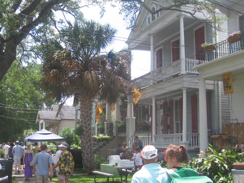
Not surprisingly, palms in South Louisiana aren’t limited to grand public lawns or rights-of-way; numerous households have adopted them as trees in front lawns, as seen below in New Orleans in May:

As evergreens, palms during this St. Patrick’s Day parade retain their leaves.

Compare this to the deciduous trees of the area, such as the crepe myrtle, which are just starting to spout their blossoms and young leaves at this time.

Palm trees, at least the genera that flourish in Louisiana, provide little shade from the sweltering Louisiana heat. Many species are high-maintenance, with considerable susceptibility to malnutrition, vitamin deficiency, or pest infestation. Particularly tall palms are vulnerable to lightning strikes. The dramatic fiery backdrop in the photo below only serves to emphasize these palms’ height in comparison to neighboring trees.

A quick scan of the landscape upon landing in a city like New Orleans should easily reveal that the majority of trees in south Louisiana are not particularly tall. Compare the palm with the mighty live oaks, featured in an earlier blog post, with a canopy that puts the palm’s to shame. But live oaks earn all their majesty from their breadth, because they’re quite short; they have adapted evolutionarily to the region’s high propensity for hurricanes by keeping their center of gravity low. Palm trees have evolved to resist storms as well; the long trunk and narrow fronds do not provide a high profile for wind shear. And of course, palms are omnipresent along tropical shorelines. But the gulf coast of Louisiana is almost completely devoid of beaches; nearly all of it are consists of wetlands that have been rapidly eroding in recent decades.

Do these pieces add up yet? A quick trip to some of the swamps outside of New Orleans should reveal why I could definitively answer my friend’s question with “no”, without hesitation.

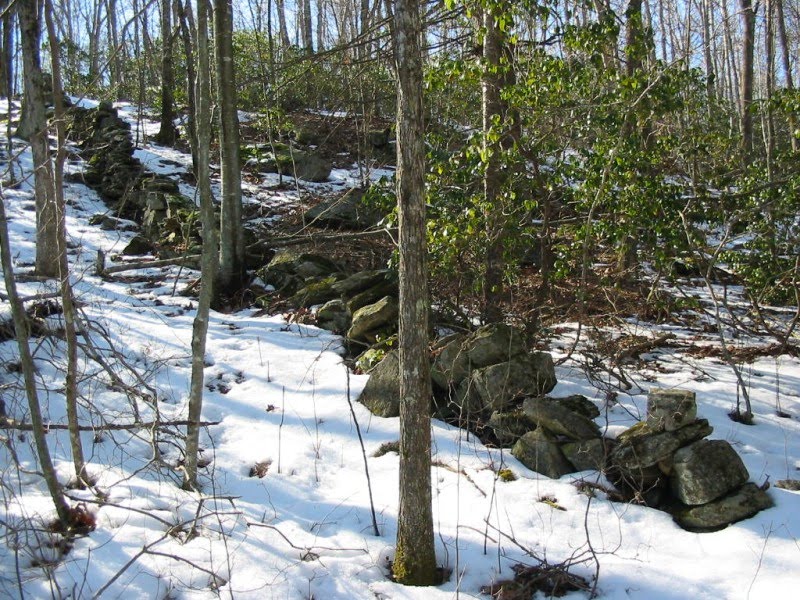
Here in the swamps south of the city, near Crown Point, Louisiana, palms are nowhere to be seen. Though frequently privately owned, many of the commercial wetlands attempt to offer tourists an authentic exposure to a cypress swamp; the land is also frequently used for hunting and fishing. Taken in January, these photos show the predominance of deciduous trees in what could be considered “real” Louisiana. From the photos above, it almost looks like it could be January in the Midwest.

A photo elsewhere down this waterway (it was a canal, much as I’d like to say it was a bayou) shows a little bit more verdure than one would ever encounter in the icy north in January. To the right in the photo below, within the red circle, is the dwarf palmetto, one of the most northerly members of this family; apparently it can survive as far north as Ohio and Pennsylvania, though its appearance is rare.

It would appear that the riparian understory does support flora that remain green in the winter; the taller trees in the background clearly don’t share this feature. Most apparent, however, is the absence of any towering palms or other evergreens; away from the cities and persistent human influence, the trees do not grow. They are not native.

So why, despite their potential health problems, are palms widely visible in the urban areas of south Louisiana? It’s quite clear to me that, as ornamentation, they have a richer symbolic content than most other trees—they immediately evoke the tropics and associative warm weather. Obviously this is hardly an insight: just think of any postcard or airbrushed t-shirt from Florida. What better way to greet tourists arriving from Saskatchewan than with a cluster of palm trees as soon as they step outside the New Orleans airport? Any beachfront community will have them if their climate can withstand it; those that cannot, such as the boardwalks of New Jersey, often decorate their streetscape with fake plastic palms.

Private homeowners may have adopted the tree for its aesthetics, but I don’t doubt for a minute that civic leaders of New Orleans and Baton Rouge decided many moons ago that they wanted to instill an ambience of tropical languor. Perhaps they borrowed it from Los Angeles, whose street palms are so intertwined with common perceptions of the city that we often cease to be fully conscious of it. “Oh, there’s a movie scene with lots of cars and palm trees whirring by; it must be L.A. New Orleans may boast a humid subtropical climate, but it can on occasion be bitingly cold in the winter, sometimes dipping below freezing with high humidity, manifested by the snowy photo linked above from 2008. But south Louisiana rarely if ever experiences prolonged cold, so the palms survive, gently helping to evoke a city tucked into a jungle. And having boulevards lined with palms adds to the city’s cachet as an aspiring counterpart to Los Angeles, a second Hollywood (Nawllywood).

With the exception of the dwarf palmetto, these various palms are introduced species to the Louisiana landscape. Are they invasive species? Judging from the photos in the swamp tour, I suspect not—they grow adequately in Louisiana’s climate, but have hardly flourished outside of areas where they are overtly cultivated. This contrasts sharply with the quintessentially southern kudzu, mistakenly introduced in the United States as an erosion remedy which inadvertently proliferated at the expense of other native plants.

So earlier generations introduced the palm family to the American Southeast to serve purely aesthetic aims and it has generally blended well when under horticultural supervision; conversely, they introduced kudzu for ecological palliative and restorative ambitions and it has wreaked havoc. Both plants have accrued symbolic associations that, at least in cities like New Orleans and Baton Rouge, do not exactly harmonize. Kudzu carpets the muggy American South with such ferocity that it could not help but forge its own association; almost every homeowner has had to deal with it at some point. The palm family is a bit more precise, with associative staying power in Florida or coastal Carolina (obviously as part of South Carolina’s flag), but it doesn’t resonate as much inland, away from beaches. It might serve as an attractive embellishment in New Orleans, but it doesn’t leave a strong statement the way it would in Los Angeles. Palm trees are coastal; New Orleans, despite being surrounded by water, is not…at least not yet.

One plant surpasses either kudzu or palms at evoking the muggy clime of the Deep South: Spanish moss. Just a little further along that waterway in the swamp tour, some live oaks were brandishing a full variety of this peculiar epiphyte.

Perhaps its precision gives Spanish moss its advantage; it doesn’t stretch everywhere across the South like kudzu (you probably won’t see it in Tennessee or Arkansas), and, unlike palms, it doesn’t immediately recall vacations on the beach. Tourists don’t escape to the world of Spanish moss; it’s a web that tangles itself into the rich humidity of Louisiana and Mississippi—literally too, since its perch along tree branches allows it to capture the thick moisture in the air. If anything evokes Southern Gothic, it’s a silhouette of a tree with Spanish moss lazily draped amidst its leaves. Incidentally, very few of the urban live oaks in New Orleans carry Spanish moss—quite a contrast from the photo above. The only place a visitor is likely to see this peculiar angiosperm is in the large public spaces—open unpaved stretches like Audubon Park and City Park, where groves of live oaks still carry the plant on their branches. You can just barely make it out on this photo below, in City Park’s sculpture garden.

Why is Spanish moss hard to find on oak trees grown in back yards or canopied over city streets, yet the parks still seem to have them? I can’t help but wonder if the plant only thrives in open spaces, but otherwise struggles if an area is too urbanized. And the City of New Orleans Parks and Recreation decided to import it for its parks, deliberately flinging it onto city-owned trees to add Southern Gothic flavor in a city steeped with such tradition. Of course I’m probably projecting conspiracy theories, but it is clear that both cities and private landowners reduce certain plants to commodities, not just for agricultural or ornamental purposes but even because of the semantic legacy embedded within them. The future of New Orleans and coastal Louisiana is unclear. Whether it becomes a vibrant cousin of Hollywood or a tragically engulfed Atlantis, the plant life both within and outside of the cities—often quite distinct from one another—will always offer cues to the region as a sociocultural and ecological “other” – a piece of exotic pseudo-tropicalia here within our own borders.

Tuesday, November 17, 2009

Does a sluggish economy encourage inferior design?

Say what you want about aesthetics; I’m not talking about exposed power lines today. The unfortunate development featured here has undoubtedly already faced the scorn of many urban advocates, but I don’t want to offer a critique as much as a narrative. I have obliquely featured the near-northside Indianapolis neighborhood, Fall Creek Place, multiple times in this blog so far, though it has never been the focal point of a post. Even in this instance, the property in question is on the periphery of this rapidly gentrifying neighborhood. Lincoln Park Place was a widely heralded new project at the intersection of 25th and Central Avenue when it was announced a few years ago, signaling that Fall Creek Place had come along enough to attract a relatively high-density condo development with first-floor retail. Witness the rendering:

The design may appear unremarkable to some, but at least the developer was maximizing potential in an area in which new development would have been unthinkable a decade ago. The fact that its location on Central Avenue puts it on the eastern edge of Fall Creek Place (most of the neighborhood stretches to the left in the photo/rendering above) made it that much more audacious. Alas, reality rears its head and fails to live up to expectations. As of the fall of 2009, this is what we see at that busy corner:

The sign announces a fall 2008 opening, but in actuality the “repurposed” Lincoln Park Shops has only been finished a few weeks. Aside from the date listed, the rest of the sign accurately captures what we see there today:

Pretty much a strip mall. My first reaction when I saw this was bewilderment and annoyance at how the community could allow this. I would hardly marvel at whether the City’s Department of Metropolitan Development would allow it, because it typically approves any project regardless of its negative impact on urban character. But wouldn’t at least someone in the area want to see something better go up at this intersection, especially considering that it’s just a few blocks from the dapper Douglas Point Lofts? For that matter, wouldn’t the developer want to maximize the property’s potential IRR through higher density as well as remain competitive to the superior retail offerings in the neighborhood?

The simple story here should surprise no one: Teagen Development, Inc. stumbled into the dreadful timing of a faltering market cycle and could not get financing for a project with the ambition (and expense) of a four-story, 26-unit condo development, after the demand for condos—and home sales overall—plunged. So he downgraded. The result, however, isn’t the garden variety, suburban strip mall, despite the abundant parking along both Central Avenue (seen above) and 25th Street (seen below).

No, what we see here would not pass muster in the suburbs, at least by today’s standards. The roof and (I’m pretty certain) the siding are both made of corrugated tin.

The fenestration on the front, particularly the recessed portion, isn’t open or contiguous enough to appeal to many retailers.

And the rear of the building doesn’t allow vehicular access, inhibiting good opportunities for the unloading of merchandise.

This is more akin to the type of strip mall one might see in a rural or unincorporated area, where both the lack of regulation and a less discriminating customer base would foster far more lenient design standards. Suburban strip malls are so abundant these days that they have adopt a fresh, reasonably tony design to attract tenants. Will the repurposed Lincoln Park Shops achieve as much? It already has secured a yoga studio—no doubt the perfect urban tenant that demands considerable GLA without a need for window frontage or merchandise.

I must now put an end to the criticism and supply some historical context that explains why this might have been a very shrewd decision on the part of the developer. Thankfully, this jerry-built storefront is not new or original construction. It’s an old building that previously hosted the Tim and Avi’s salvage store, and though I have no photos of its previous appearance, a pretty good representation exists on Google Street View. The developer reclad the structure, upgraded the piping, added the windows, and poured the asphalt lot to the east and north sides. Ultimately the changes to the existing structure were modest; it probably only required a basic renovation permit, but it certainly didn’t need to be vetted for complying with urban character—in terms of massing, the structure remains the same as before. Though it was never what he envisioned for the site, one has to respect the fact that he had carrying costs, and the longer he let the building sit unoccupied, the more it could deteriorate. Some critics may charge that he could have reinvented the project as apartments, but most condo developers have no intention of being property managers. Banks may have been just as hesitant to finance an apartment in a location still perceived as risky. The developer might also have been able to renovate the old warehouse with personal equity or a significantly lower loan-to-value ratio, since he was able to forego demolition costs, among others.

Instead of new construction, the neighborhood gets urban adaptive re-use, a compromise resulting from the relentlessly sour economic circumstances. The fact that the developer chose lightweight and relatively low-cost materials for his renovation of the old warehouse suggests that the current manifestation is not a permanent one; even the website suggests that Lincoln Park Place was “deferred due to market conditions.” My conversation with the developer was less promising: he said it will remain in its current form for at least five to ten years because he’s already secured leases with several tenants for that duration.

Were the decisions that led to the demotion of Lincoln Park Place the most prudent given the circumstances? Perhaps the carrying costs were modest, and if the developer waited until a favorable market cycle, he could have easily secured financing and struck gold. But it wouldn’t be the first development proposal to go bust at this intersection. Across the street is a much more imposing structure:

Local blogger Dig-B reported last year that this site, too, once held promise as a condo conversion but has since fallen off the map completely. The intersection may see its day in the sun in just a few years. Even if the prolonged depression has significantly curbed the public’s appetite for condos, it shows no sign of stifling the appeal of urban living; most apartment developments in downtown Indy are continuing progress, and a few new ones have begun in recent months.

Investigating the full narrative arc behind the underwhelming Lincoln Park Place has tempered my initial frustration to a mere disappointment. Sometimes a stalled development caused by a poor economy can serve as a blessing in disguise; after all, it can stymie a potentially bad development, with the passage of time allowing the site to culminate in something much better down the road. If this strip mall is the result of risk aversion, no doubt the neighborhood could have done much worse. What remains the most vexing about this output is that it suggests that, even in a location that is ostensibly growing more desirable with each passing day, a developer and bank would perceive something scaled to the needs and density expectations of the neighborhood as risky, but a suburban or exurban commercial strip remains a surefire bet. Perhaps if the economy were booming, we could witness the same sloppy results—a more laissez faire attitude to new projects because they are numerous, and none of them receives the same scrutiny they would if the pace of development were slow and steady. No doubt better things are in store for the intersection of 25th and Central, but it might require the middle-of-the-road pace of life and development that frequently characterizes Indianapolis to achieve those desired results. “The truth is somewhere in the center,” says the Midwest yet again.

Sunday, November 15, 2009

Campuses have back yards too.

Though I had driven through the mid-southern boomtown of Nashville before in the past, this past weekend was the first time I had left the interstate to tour the city briefly. One of the first stops was the venerable, woodsy campus of Vanderbilt University, just a mile or so away from the city center. Much of the campus offered exactly what one might expect from an older urban academia: uniform, solid brick buildings with limestone Doric columns, well-maintained grassy quadrilaterals crisscrossed with foot paths, a generous tree canopy (at least in the summer), an alarming overpopulation of squirrels. Those more familiar with Vanderbilt can surely describe it better than I; those unfamiliar at least can conjure a facile image.

What took me by surprise was a chance encounter with this beast in the southern half of the campus:

And of course, this pole’s identical siblings stand approximately 250 feet away in either direction. It’s rare to see such a jarringly large utility line in the interior of a campus. In fact, it’s rare to see utilities on a campus at all—nearly all private schools are willing to front the cost to run the lines underground.

In many ways, the presence of overhead wires in urban settings distinguishes the US from most other developed countries. The American landscape is littered with them, even in relatively dense inner city neighborhoods. Only a few settings come to mind in the US where electric wires are not widely visible: downtowns usually employ buried cables, as do newer subdivisions built since the 1970s, and large parcels under single corporate ownership (such as a university). The comparative lower density of US cities no doubt necessitates much higher costs for burying wires than would be the case in, for instance, the Netherlands. Our population is spread over a significantly greater land area, and loosely translates to negative economies of scale in terms of the square footage of cable per person served, equating to higher costs in physical utility installation per person, whether as poles or undergrounded. However, overhead wires elicit other inefficiencies: they are far more likely to suffer power outages from fallen tree limbs or toppled poles after storms or heavy wind. Many urban utilities companies must pay for tree trimming on private lots to protect the cables from snapping, with costs most certainly passed down to the consumer. Utility easements grant them this privilege, resulting in roadside properties with funny-looking, lopsided trees.

Conversely, undergrounding cables never completely eliminates the possibility of power outages, and a severe outage on an underground system may be harder to access or repair. In addition, cities that engage in a fair amount of road alterations such as widening or storm sewer additions may find that underground cables are far easier and cheaper to maneuver around, while underground cables would cost a fortune to relocate. Regions with a high level of seismic activity also need to be conscious of the vulnerability of buried electrical cables. I have also read on occasion that the speed of electrical transmission across great distances is inferior on underground cables, thus explaining—beyond the sheer costs—why sparsely populated rural areas almost always depend on overhead cables. (My source on this last bit of information is questionable; perhaps an electrical engineer can confirm or contradict it.)

Arguments favoring and opposing overhead cables are clearly numerous, often leaving the investment decision at a stalemate, in which each location gets individual consideration. The one determinant in which buried cables always wins is aesthetics. Overhead cables are an unsightly blight on the landscape to most people—no doubt many commercial photographs of great vistas have had the power lines blotted out courtesy of Adobe Photoshop. So why did Vanderbilt choose not bury these lines that rest fully within the campus? My guess is the answer is quite simple—this is not a part of the campus that Vanderbilt leadership wants or expects most of the public to see.

In hindsight, I’m kicking myself for not taking more good photos of the campus, but the combination of what I did take and some campus maps should get the point across. The oldest part of the campus remains sequestered from the majority by busy 21st Avenue South:

This area (outlined in blue in the campus map below) is known as the Peabody Campus, because it originated as the George Peabody College for Teachers upon splitting from the University of Nashville in 1875. In 1979, it merged with Vanderbilt University and assumed the name Peabody College of Education and Human Development. While the majority of the top-ranked graduate school of education classes take place on the Peabody Campus, its buildings also host classes for undergraduates, administrative offices, as well as some dormitories. Its largest distinction is the strictly geometric layout of its buildings, somewhat visible in the photos as well as the campus map.

The distinctive origin design of the Peabody campus design becomes more evident when contrasted with the historic main campus of Vanderbilt to the northwest. Indicated by the red outline in the campus map, this section of “Old Vanderbilt” adopts a much more organic campus layout—looser and much less emphasis on perpendicularity than the Peabody Campus.

Apparently the biodiversity of this portion of campus has earned it the designation as a national arboretum. This section and the Peabody Campus receive the highest level of utility upgrades; not a single overhead cable is visible here.

The approximate spot where I took the original photo of the utility pole is indicated by the orange circle on the campus map. This area, and virtually everything to both the south and west of it, represents the preponderance of Vanderbilt’s expansions. Most of the university’s expansion began in the 1950s, and it shows. Whereas Peabody and the old Vanderbilt campus are almost completely pedestrianized, with the majority of academic buildings fronting foot trails, the newer portion of the campus reflects the more automobile dominating ethos of the time. Unfortunately the only photo I took that accurately demonstrates this is the first one on this blog post with the utility pole, but it at least hints at the widespread campus design typology of the second half of the twentieth century. The cars, parked perpendicular to the curb, enjoy dedicated parking along a right of way that does not function as a city street, nor is it purely a parking lot. These “campus roads” that weave their way through most universities of a reasonably size usually have two origins: they are formerly city roads that served a residential neighborhood, both of which (homes and road ROW) have been purchased and claimed by the university, giving the school the freedom to design traffic flow and parking to its own standards; they were integrated into the university’s own master plan and never existed as part of the public right of way, again giving the university almost unlimited freedom. In this case, I suspect these campus roads owe their current existence to the first of the two aforementioned scenarios. The brown lines I have traced on the campus map show an inchoate grid pattern that most likely formerly serviced private residences; many of the homes where either purchased or demolished by the university to make way for fraternities and sororities. The roads directly serving the Greek housing still maintain many of the characteristics of conventional rights of way, but one street (indicated by the brown line that terminates in the orange circle) looses its ROW character and becomes more of a logistical service route, with dedicated parking. This is also the point where the conventional urban grid breaks down and, instead of the roads defining the shape of parcels and the buildings that rest upon them, the building alignment seems to have dictated part of the trajectory of the road. I’ve included a few more photos below that show how this phenomenon influences the buildings in the new campus, provided from the Vanderbilt website.

Lupton Hall is one wing within a larger quad structure, but it rests on Vanderbilt Place (no doubt purchased by the university but with public access) and it features a separate vehicular drop-off point.

The Ben Schulman Center for Jewish Life is a particularly new addition at the corner of Vanderbilt Place and 25th Avenue South. The off-street parking is marginally visible to the far left.

The need for 22,000 square feet of parking would have seemed unconscionable prior to the expansion, but by the time the Kensington Garage was built at the intersection of Kensington Place and 25th Avenue South, it critically served university staff and faculty as well as guests to a neighboring hotel.

Most likely my original photo featured a different perspective of this 1920s-era power house. The prominent smoke stack is an unlikely feature not commonly seen in most campuses. Interestingly, the campus website claims here that all house-run utilities are underground, which leads one to question why it would make such a claim when above ground facilities are plainly visible. Could it be that the power lines running through campus service other parts of the city and the City of Nashville simply needed to wind across parts of Vanderbilt campus?

Regardless of whether the utility placement is by-right or by easement, it clearly remains the underbelly of the institution—the mess of wires and gears that makes the place tick. Nearly every major campus has a portion like this—the section where aesthetics took a back seat to the convenience of parking, or vehicle unloading, or the necessity of a close electric substation. It would be lunacy for Vanderbilt’s admissions office to coordinate tours in this portion of the campus—the whole area feels like logistical roads for vehicle unloading, while the main entrances to the buildings themselves seems almost hidden. Like most urban development in the 1950s and subsequent decades, both the scale of the structures and the flow created by linear paths disfavor the pedestrian. The buildings might be generally close together and contiguous with the old campus—after all, students aren’t necessarily going to own cars and will still need access to the expansion sections of campus—but the planning seems far less cognizant of foot traffic than 19th century Vanderbilt, which is human scaled by necessity. The new campus seeks to accommodate both the car and the pedestrian, but it is axiomatic that only the pedestrian will make any sacrifices in this case. The result is sprawl, university style.

This dichotomy between old and may have little bearing on the overall success of the university, but the fact that campus facilities has made no effort to conceal those aggressive electric poles speaks much about the aesthetic stance the university takes to its new development. Most contemporary American cities are devoting an inordinate amount of resources to revitalizing their downtowns, largely because, no matter how much it may decentralize, the downtown remains the foremost location by which an outsider is going to form an impression of a city. Downtown is the city’s front door. Accordingly, old campus and Peabody are the front door of Vanderbilt—the images of walking tours, of postcards, of an officially dedicated arboretum. Some of the suburbs of metro Detroit are lovely—but the first images that come to mind when one thinks of Detroit is a decaying old city center from Robocop. I am not denigrating the development patterns and practices from the age of the automobile, but the positioning of the old historic center of downtowns and campuses demonstrates a perhaps unconscious preference for the way old walkable hubs look and how they accommodate visitors. Contemporary downtowns are increasingly adapting to a growing demand for building and street designs that engages the pedestrian. Most likely, subsequent development at Vanderbilt will follow the same pattern, eventually minimizing the back yard, no-man’s land feel that comprises a significant portion of the campus. And in time it may also impel the university to bury those power lines.