
Happy New Year's wishes to all, though this blog ends the year on a bit of a sour note. My computer revived while in the States, but, now that I'm back in Afghanistan, it seems to have failed again--while another December blog post was in the process (among the only files that was not backed up). All my photos are also stored there, and while most are backed up as well, it is very difficult (and a bit risky) to manage external hard drives while working on shared computers over here.
Until I figure out what is wrong with this computer, or purchase a new one, I'm going to have to do the unthinkable and put this blog on hiatus. This could be only a matter of a few weeks, though it may also be a few months, since it's possible I'll be in Afghanistan that long and I don't want to bring a brand new computer into these living conditions. All is well otherwise, I wish you the best start to your 2012, and please stay tuned.
Saturday, December 31, 2011
Saturday, December 24, 2011
DUST: Bringing the basic training obstacle course inside the wire.
The integration of pedestrian infrastructure into the expeditionary base environment in Afghanistan has proven far less contentious than one might expect. A culture that prioritizes short-term efficiency over long-term functionality (at least partially evidenced by my article on building code violations from nearly a year ago) would seemingly scrutinize exclusively on infrastructure that accommodates gargantuan armored vehicles that need to get around with as few obstructions as possible in order to complete their respective missions. But the fact remains that only a small fraction of the people use MRAPs, Humvees or the all-too-rare tanks to get around. A slightly larger fraction use Toyota trucks, but because most people enter and leave a base through from the air, the number of vehicles on base isn’t nearly great enough to accommodate everyone. Most people get around by foot.
While the infrastructure might not be as conducive to pedestrians or bicyclists as your average neighborhood in Portland, it’s not as bad as many bases on back on American home turf, which are consistently spread out across huge tracts of land, with huge standoff distances between buildings intended as a protective measure in case of a vehicular explosive attack. Afghan bases are typically densely settled, or, at the very least, most planners recognize the efficiency of clustering residential tents and ensconcing them within ample protective barriers. And while grade separated sidewalks are not too common— particularly at the smaller bases that usually have the shortest life span—the regulatory and operational culture recognizes pedestrians. Speed limits for vehicles are incredibly low, often only 20 kph (12 mph), with fines for violators. Many units require their personnel to wear reflector belts at all hours, just to keep them prepared if the sun sets when they are out. (Most bases are fairly dark, and some are completely blacked out for safety, so pedestrian visibility is critical.) American soldiers must wear helmets if they ride bicycles. The larger bases often devote their sprawling outskirts to storage and industry, so they must employ a shuttle system with various mapped stops for ease of getting across those vast distances. And some of the largest bases, such as Bagram Air Field, close off primary arterials at certain early hours in the morning to all vehicles to devote the road for running and PT (physical training). In a multinational base, the American penchant for order and enforcement promotes a higher standard for pedestrian safety for its soldiers than is evidenced by the more relaxed coalition forces of other countries: coalition forces do not live under a mandate for reflector belts, nor does it seem that speed limits apply (at least for the Germans). This dichotomy between US and Europeans proves ironic, since the Germans, Swedes, Croats, and Latvians are more likely to come from a pedestrian friendly, densely populated settlement pattern back home than the Americans, yet the American rules are superior at promoting safety for the numerous troops and civilians depending on boots and bikes.
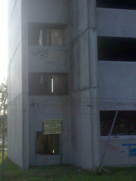
In contrast with the regulatory environment, the road design in expeditionary bases isn’t always great: sidewalks are inconsistent, rights of way are narrow, turn radii don’t accommodate the really long vehicles, drainage (if it exists at all) usually consists of wide-open ditches along the verge. But pedestrians and vehicles coexist reasonably well, thanks to those vehicular speed restrictions and a culture of awareness among drivers and walkers, particularly visible among the Americans in the multinational-base in which I reside. I have yet to hear of an accident, which is always a good thing, but particularly so on a military base, because a collision between a person and an armored vehicle would almost certainly result in death. However, force protection requirements sometimes trump other safety considerations, so that the design of a compound simply accounts for defensive barriers in the event of an external attack, rather than thinking about pedestrian safety and explosive defenses as a comprehensive protection strategy. As a result, it is not so hard to find situations such as the one below:

The wall on the left consists of what the military simply calls “HESCO”, much to the advantage of the UK-based HESCO Bastion company that manufactures them. HESCO enjoys a virtual monopoly on this distinctive fortification, known generically as a gabion (its brand name is a Concertainer), which essentially consists of tall (approximately 8 feet) durable paper bags enclosed in a thick wire mesh and filled with a combination of soil and a concrete topping, intended to absorb much of the impact of high speed missiles or mortars without eliciting dangerous projectiles if the bags themselves explode. The helices of concertina wire that coil on the top help keep out intruders.
Anyone who has read more than one or two of my blog posts can guess what I’m identifying as the problem in that photo above: there is simply not enough room on the side of the road for people to walk safely. The scaling of the objects does not quite capture the problem, but this footprint in the dirt does a better job of it:

It’s narrow. During the day, this proves a minor annoyance which a person can at least in part avoid by walking on the other side of the street. The real threat is after dark, when neither side of the road is terribly appealing, since the darkness would obscure the obvious tripping hazard found in the open drainage ditch, only a few portions of which are covered and protected.


And the typical base in Afghanistan is shrouded in absolute darkness with few isolated exceptions—a particularly salient problem during the long winter nights. I’ll admit that I tend to sound the warning bell in situations like this far sooner than the average person would. So this design deserves a special mention because multiple colleagues have also pointed out the safety hazard this poses. Why did the original squadron build the HESCO wall so close to the street? No compound is so crowded that the construction team couldn’t afford to shift the barriers at least a few feet inward to make room for walkers, or a drainage ditch for that matter. Turning the corner at the next intersection and pivoting to the left, one can see that on the next perpendicular street, the gabion of HESCOs offer plenty of room for both pedestrians and a drainage ditch.

The photo merely depicts a different wall to the same compound, this time with ample room for drainage and pedestrians. This road segment, far closer to achieving a US model of a Complete Street, also features intermittent wooden bridges across the drainage ditches, prominently visible in the photo above on the opposite side of the street. At night, these bridges feature blinking LEDs that both manifest the bridges to pedestrians as well as identify the edge of the road to passing vehicles, so the drivers avoid hitting and destroying the wooden bridges or slipping into the adjacent drainage ditches.
A bit further down the road, one can witness a rare installation underway: sidewalks.

Until this newly laid segment, sidewalks were unheard of in the American portion of the base. Most of the smaller bases with populations under 10,000 (which is practically all of them) have no sidewalks whatsoever. Sidewalks are intermittent in the German portion of the base, as visible in the photo below:

But they aren’t everywhere in the German portion. About 500 feet down the same road, the configuration of the Relocatable Buildings (RLBs) is identical, but the street lacks sidewalks, bollards, or drainage ditches.

The Germans can be just as cavalier about accommodating pedestrians as the Americans have been. I scrutinized the German street design in greater detail in this earlier blog post).
The contrasting appearance between the various road segments identified in these photographs delineates a dichotomous approach to expeditionary base construction: permanent versus temporary. As the photos above indicate, German billeting is overwhelmingly permanent: the modular buildings sit in lengthy rows of two, unified by a central hallway, like a conventional double-loaded corridor hotel building. Some of the central offices and meeting spaces even use brick and mortar construction. By most regards, these buildings function at a higher standard of quality and durability, predicating upon the assumption that, since the German military purchased the land, it will maintain a presence at this base for the foreseeable future. Hungarians and Croats also appear to prefer the permanence of relocatable buildings. Conversely, at this same base, Americans use tents:

So do the Norwegians.

As do the Swedes, Finns, Latvians, Armenians, and Dutch. While I can’t vouch for the other Coalition Forces, I knew that the American mentality is that everything they construct should be capable of disassembly in 48 hours if necessary, leaving as little of a permanent footprint as possible.
I wouldn’t begin to assert that one approach is better than another—I’m not sufficiently informed on the long-term plans of Germans, Croats, Swedes, or even Americans for that matter. Permanent and temporary construction practices both have their merits. The average German base will, based on its construction materials, transition much more conveniently to eventual use by the Afghan National Army. The American bases won’t transition so easily, but if the priority is to get out and return to the land to the Afghans in a more fallow state, then clearly the non-permanent approach is wiser. My only concern comes in all the impervious surfaces used throughout the base—a topic which effectively concludes this rumination on pedestrian infrastructure.

It seems like a smart decision for the Americans to build a sidewalk along a stretch of road that hosts the American PX (Post Exchange, the closest thing to a big box store), a coffee shop, a Pizza Hut, a future Burger King, and, on the other side of the road, a USO Tent, post office, gym, finance office, chapel, and computer lab. It is undeniably the road segment in the American quarter with the highest amount of pedestrian traffic. But a concrete sidewalk is permanent. So are the drainage culverts, the basketball courts, and the foundations to all those tents. In short, the vertical element is what constitutes “temporary” in American expeditionary base construction: when we leave Afghanistan, it will look empty when standing on the ground staring at the horizon line, but peering downward from a helicopter will reveal a patchwork of pavement. How likely is it that the Americans, Swedes, Norwegians, et cetera will actually remove or destroy all that concrete—or, for that matter, the far vaster ocean of gravel that occupies most other unpaved, habitable portions of the base? Then again, even concrete pads and paved streets can prove a significant investment that would allow Afghans more freedom to build upward from an existing configuration. Concrete pads for temporary FEMA trailers in Louisiana after Hurricane Katrina helped pave the way for the possibility of more permanent mobile home parks after the immediate need had subsided. Paved roads, drainage ditches, and sidewalks are amenities that much of Afghanistan does not enjoy, so although paved infrastructure forces future inhabitants into a certain configuration, it does provide provincial governments with infrastructure that they otherwise cannot always afford. A middle-of-the-road approach—combining permanent infrastructure with semi- or non-permanent structures—may prove the wisest compromise. Though I doubt that engineers at my compound will ever correct the mistake of building the HESCO gabion too close to the road and squeezing out the pedestrians, at least the potentiality for a correction remains in ways that wouldn’t if a permanent brick wall ran along the road instead of soil-filled bags. Like all other aspects of expeditionary base living, pedestrianism is malleable—precisely as it should be when tomorrow’s exigencies could require an immediate change in the urban form.
Tuesday, November 29, 2011
Technical tangles.
This month has been a little arid in terms of posts, and some of it is due to workload, but a lot is just due to poorly functioning IT over here. Due most likely to an unusually cold, rainy and snowy November, we have had very inconsistent Internet access--usually less than half of a day. That has hindered my flexibility in getting the blog completed at a reasonable clip.
In addition, the battery to my personal computer just went dead, leaving me without any option for uploading some of my most recent photos. I will get this situation fixed so that I might be a bit more productive next month. And, since I will soon be ending this contract in Afghanistan, my blog will hopefully soon include some very recent photos and hopefully my postings to this blog will occur a little more frequently. As always, thanks so much for reading.
In addition, the battery to my personal computer just went dead, leaving me without any option for uploading some of my most recent photos. I will get this situation fixed so that I might be a bit more productive next month. And, since I will soon be ending this contract in Afghanistan, my blog will hopefully soon include some very recent photos and hopefully my postings to this blog will occur a little more frequently. As always, thanks so much for reading.
Saturday, November 26, 2011
MONTAGE: Washing and cleansing every stain from the sin of neglect.
This montage blog post pioneers an unusual organizational approach: the time elapse. During a six-month period in which I was living in the city of Baton Rouge, a particular edifice caught my attention: a stalled high-rise with its load-bearing walls fully complete but little else. All evidence suggested that its owners had abandoned it quite some time ago: graffiti slathered upon the lower levels, overgrown weeds, a makeshift chain-link fence installed to deter trespassers (unsuccessfully). Sadly, these sorts of structures are all too common in American downtowns after the housing bust that began around 2008: even some of the most successful ones have some weathered relic from an era of high demand for vertically oriented condominiums that has since retreated almost completely, along with the rest of the owner-occupied market. Fortunately, many of them have since gotten converted to apartments—a downgrade by most assessments, but better than sitting vacant for years. The building that caught my attention in Baton Rouge wasn't so lucky:


It could be anywhere—except that it looked like it had been abandoned far more than three years ago. And Baton Rouge’s downtown hadn't been enjoying a huge housing boom up until the bubble burst. Perhaps most importantly, this relic doesn't even sit downtown. It would have made sense if the developer put the kibosh on construction when he or she realized the real estate wasn’t as lucrative as initially expected, perhaps due to a surrounding area that was turning increasingly low-income. But that wasn’t the case here. This faceless golem stands in one of the most sought-after parts of Baton Rouge metro, just down the street from the Mall of Louisiana, the state’s largest and probably most successful megamall. It’s not far from the Highland Road corridor, where Baton Rouge’s stateliest homes preside over large lots. And, just a mile further south sits Perkins Rowe, a high-end lifestyle center with multi-family housing on the upper levels, an ambitious project that would probably have lower vacancy levels if it hadn’t opened at the peak of a recession. Either way, this building clearly struck me as an oddity. Why was it abandoned?
The answer: it was a casualty of one of the biggest televangelist scandals in history.


The 206,000 square foot building was intended as a dormitory for students attending the Jimmy Swaggart World Ministry Center. Reverend Jimmy Swaggart fell from grace after being caught at a motel outside of New Orleans with a prostitute in February of 1988; his widely publicized contretemps may not have toppled his empire, but it certainly stalled the growth of his once-burgeoning bible college. His very public, televised apology (without acknowledging what he had done) remains legendary; YouTube claims over 150,000 views. After the Swaggart sex scandal gained momentum, enrollment at what was then the Jimmy Swaggart Bible College plunged, and construction stopped at the dorm by 1989. Apparently many other plans for Swaggart’s campus stalled in the late 1980s, and a second time caught with his pants down in 1991 only further thwarted any chance for renewing construction as a dorm. However, this building most likely advanced much further in construction than anything else stalled by Swaggart Ministries after his 1989 scandal, and this first set of photos, from May of 2010, shows it at its bleakest. (While the rest of the campus appears fully operative twenty years later, it would appear from the above photo that many of the palm trees aren’t getting the care they need to fend off disease.)

For nearly two decades, a concrete shell sat there in lugubrious decay, even as the area around it boomed, culminating in the construction of the Mall of Louisiana in 1997. Finally, the abandoned shell caught the interest of a developer, who in 2007 hoped to begin rehabilitation of the structure to convert into a high-end hotel, but the real estate and financial market’s slump prolonged the delay. A somewhat recent Associated Press article that the developer ultimately scaled the project down from an initial $75 million proposal to a more modest $42.5 million: a 256-room hotel with conference rooms and a ballroom. Interestingly, the Louisiana Legislature applied Tax Increment Financing (TIF) to expedite the project, which uses the estimated future sales tax revenue to help finance a project that might otherwise lack either the equity it needs or is unable to secure an adequate loan. While this tactic is common throughout the US, governments normally apply it in economically disadvantaged areas—not directly across the street from a metro’s most successful shopping hub. The City of Baton Rouge also granted tax credits under the state’s restoration tax abatement program.
Though it lacks the materials, plumbing, wiring or mechanical engineering that would be most vulnerable to inclement weather or thieves, the cement skeleton still shows considerable wear and staining from elements.


Ten-foot tall chain-linked fences and threatening signs aren’t enough to deter the graffiti artists.
And many of the vandals made their way up to the top floor.

A return visit to the site a little over two months later (near the end of July 2010) revealed a surprising level of further deterioration and graffiti.


My one college course in materials science doesn’t provide me much illumination on why the concrete on the upper levels seems to be in much worse shape than closer to the ground, but it is obvious that these higher floors are deteriorating considerably. Could that have really happened so quickly since May?


It looks systematic, as though it involved a human hand, dismantling the top floors and working the way down. An orange outer fence on the front side (facing the principal arterial, Bluebonnet Boulevard) appears to have been installed much more recently and suggests the sort of deterrent used for construction projects.

At this point, without having read anything about plans for the site, I had drawn the conclusion that the building was getting demolished, an assumption substantiated by the presence of backhoes and other earth moving equipment.


And, at that point, my chronicle of this building seemed likely to come to its end; shortly thereafter I was reassigned another city. Thankfully, my ever-loyal blog-follower and South Louisiana native, Nici English, remained close to the Red Stick and was able to follow it over the ensuing months. With a sharper pair of eyes and an undoubtedly better camera, her professional approach picked up where I left off. (And I cannot help but offer a shameless promotion, since she more than deserves it: her personal site, Oak Tree Photography offers breathtaking black-and-whites of the built environment across a number of southern cities.)
The developer had clearly taken real initiative over the winter: by late February of 2011, the “Swaggart dorm”, as we call it, was taking on a new life, with the installation of what appears to be insulation.

Note that the developer has apparently deemed it unnecessary to remove the graffiti on the concrete at the ground level of the building.

A few weeks later, a sign offer promise of what is to come:

By late August, clad with what I strongly suspect is EIFS, the Renaissance Hotel is starting to establish its identity.

And, in mid October, the building opens to the public.


It appears that some of what I saw as deterioration on that top level was actually an alteration of the fenestration: hotel rooms generally emphasize larger windows than dorms. I’m not going to pick apart the architecture any more than to acknowledge that the huge “Renaissance” sign atop the roof manages to compensate for its dull typography by suggesting to me a throwback to the 1950s—a time when rooftop signs for hotels were commonplace, even though at that time the majority of Baton Rouge’s hotels would have likely been downtown and not off a major highway in suburbia (especially not on Bluebonnet Boulevard, which was nothing but countryside sixty years ago).
It was almost twenty-five years in the making, but now this plot of land has a structure worthy of its market value. In a less sour economy, this suburban arterial would probably see many more construction projects capitalizing on every developable square foot. As it is, the redevelopment of the Swaggart dorm represents an ostensible public-private partnership effort at revitalization, the heart of which remains a mystery. Did the area really have to depend on a TIF and tax credits to turn the blighted Swaggart dorm around? Perhaps I overstate the area’s desirability: if it were that lucrative, something would have been erected a long time ago. But the truth of the matter, I suspect, is that the area really is desirable, but a stalled mid-rise project throws a wrench into any other efforts. The cost of demolition before a developer can build may offset the area’s intrinsic market advantages. As mundane as this project may seem, it may have taken a shrewd developer with an eye for the building’s “physiognomy”—coupled with a city/state government willing to go to bat—in order to get anything off the ground. And at least the Renaissance Hotel seems to be taking care of its trees; something that will hopefully inspire Swaggart Ministries to do the same for its remaining share of the campus on this stretch of Bluebonnet Boulevard.
Sunday, October 30, 2011
The college paints the town anything but red.
The phrase infill development can loosely refer to a wide variety of approaches with the overriding aim of introducing (or reintroducing) a higher density of habitable buildings into a mature, already established built environment. In most cases, the surrounding infrastructure for an infill parcel has long been in place, the adjacent properties are at least partially if not completely built, and zoning regulations already encourage a particular kind of land use. Usually the infill target is a vacant lot, often which previously hosted a structure that has since been demolished. Sometimes the parcel was simply an inadequate size or an unusual shape, precluding it from getting developed to the same degree as its neighbors; other times the zoning is too stringent and prohibits what a developer may perceive to be the highest and best use of the land. But infill does not apply just to vacant parcels. The phrase “highest and best use” suggests some sort of intervention if property is perceived to be underutilized as well. For example, in successful town centers, high property value and high density of structures usually benefit from co-dependency when viewed through the lens of land economics. That is, because the cost of land in a sought-after downtown is high, it becomes far more prudent to build intensely in such a district, which usually results in vertical development, since that’s the only way to squeeze in lots of leasable area on a small parcel. The high concentration of economic activity in these clusters of towering structures downtown helps to attract other developers and further escalating demand for a finite stretch of land. The densest, most valuable urban real estate in the US has little room for one-story buildings like warehouses or most strip malls, and even lower tolerance for surface parking lots. Thus, the replacement of a parking lot, a squat relic from the industrial heyday, or a privately managed green space with a tall structure with the potential to generate greater revenue also constitutes infill development.
In principle, the typical infill project should serve as a win-win situation for both public and private interests: the developers get to build in a usually already desirable area without incurring much of the cost of infrastructure (since most of it has already been installed long ago); the public sector gets to add a more valuable piece of real estate into its tax rolls. Yet infill projects still tend to be highly controversial across much of the US, with adjacent property owners typically raising the loudest objections. Why would they fight a development that will most likely help sustain high property values in the area while further dispersing the tax burden across a greater number of owners? The problem is that infill indisputably adds density to the district, and Americans intrinsically distrust density. While such an assertion may seem to paint the populace with a brush that is both broad and steeped in vinegar, the evidence that Americans eschew density is everywhere, and I’m not intending this statement as a criticism. The majority of American cities—particularly the older, eastern ones that predate the automobile—have largely been shrinking for more than a half century. Though rural America has depopulated as well, it is not out of the farmers’ desire to move to the city; both rural and urban dwellers have fled en masse to the low density suburbs. The US has always boasted incredible stretches of sparsely inhabited land; even as the population exceeds 300 million, it can still make this claim. But by most other countries’ standards, even the cities themselves boast vast expanses with few or no people. American cities are, on average, among the least densely inhabited in the world. In many regards, it is an achievement: a product of such aggregate wealth that we can afford to live and function with great distances between one another. It is a triumph of self-actualization. But low density also undercuts the ability for cities, often limited in their capacity to grow through annexation, to continue to administer and function effectively when people demand to live far away from one another, often outside of the municipal boundaries altogether.
The result of this aversion to density is manifest in the numerous complaints and challenges to infill development. It will cause ungodly amounts of traffic in the area. It will spark an increase in crime. It will deprive the children of outdoor space in which to play. Many remonstrators have even claimed that it will lower property values. Though such a notion goes against the fundamental intent of infill, such objections may at a micro level (both spatially and temporally) be true: if the prevailing culture of the district is anti-density, the act of shoehorning density will only undercut the overall appeal of the area and may lower demand for property. (Then again, it could attract a new demographic specifically drawn to such density.) A trick of the trade among developers who work in already high density areas is that they must inflate the leasable area of a building beyond their goal for profitability, because they will always have to cut back the density when the neighbors raise objections through their council members. Thus, a developer seeking to build a six story building on a neglected parking lot in an a tightly-knit middle class neighborhood will likely initially propose eight or nine stories; otherwise, if he or she begins with a six-story proposal, the neighbors will probably try to whittle it down to only four.
I know next to nothing about the development history of the building from the photo below, taken during a brief visit to Blacksburg, Virginia last year. I don’t even recall enough of where it’s located to attempt any research.

But I can draw conclusions based on what I know about the surrounding area. Blacksburg is unquestionably a college town, hosting Virginia Polytechnic Institute and State University, better known as Virginia Tech, the largest and most recognized higher learning institution in the southwest of the state. With a population of around 42,600 (by the 2010 Census) and a university enrollment of over 30,000 there can be no doubt that Virginia Tech is the lifeblood of the city and region’s economy.

College towns are typically more amenable to densification of the built environment than other communities of similar size. And densification is exactly what it would appear this building has achieved, since it is obviously a newer structure than either of its neighbors; it was inserted in the vacant lot between them.


The sociological conditions here are simply suitable for infill: the large student population results in a significant constituency that will only live there for a limited time and does not usually concern itself with the long-term impacts of developmental changes, particularly if they occur outside the campus boundaries. Students are rarely homeowners in towns like Blacksburg. In addition, they are far less likely to be vehicle owners: while I saw plenty of cars clearly registered under University parking, the fact remains that, common to most campuses, a preponderance of students get around by foot or bicycle. A pedestrian dominated city is more likely to see further density as an asset (one additional building that is within walking distance), and the increased density is just as likely to attract bicycles and walkers as it is to attract cars.
I’m not entirely certain on the developmental aim of this building. The fenestration doesn’t make it a dead giveaway as an apartment on the upper two floors. Though that’s what I expect it to be, the building doesn’t advertise itself as apartments, which could have proven a mistake in a city filled with renters. Why be subtle about it in an area where apartments are rarely stigmatized? Conversely, the different pattern of windows, the wooden signage, and the shaded patio seating all suggest that the first floor hosts some other retail use. The one jarring feature of this structure is the fire escape:
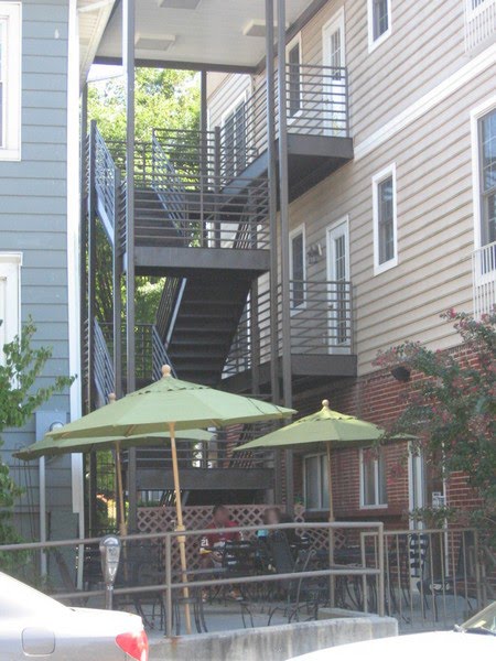
Fitting it between the new building and the adjacent blue house was quite a challenge. As one of the earlier photos reveals, the eaves of the two structures are butting up against one another. The owners of this house next door would have had just cause to complain about a deteriorated view—if they cared enough. However, I would have guessed this blue house to be a subdivided apartment building, filled with not-too-particular students and run by a landlord who knows that his backpack toting clients are rarely all that choosy. Regardless, this jungle gym of a fire escape also provides an unusual backdrop for patio seating that isn’t likely to appeal to many; the umbrellas offering shade are probably unnecessary most of the time, since a patio wedged in like this won’t usually receive too much sunlight. Wouldn’t it have been better to flip the building 180 degrees, placing the patio and the fire escape next to the shorter, virtually windowless brick structure on the other side? Then again, the targeted student customer does not usually put much stock in aesthetics of living conditions; they have the rest of their lives to worry about that, most likely in another city.
It’s hard to imagine anyone falling in love with this building from an architectural standpoint, yet it manages to offer commercial and (presumably) residential space just a cartwheel away from the campus—in the middle of a block, of all things. By most metrics it would appear to be a successful infill development. It hosts a mix of uses and contributes to Blacksburg’s tax base. And while it is possible that the neighbors subjected it to greater design scrutiny than I’m assuming, one might guess how it would have turned out if a throng of adjacent property owners had nitpicked the original plans due to some of the weaknesses that I have pointed out. Infill might sprout up more easily in a fertile, permissive culture, but the result isn’t necessarily “highest and best” from a design standpoint. Those NIMBYs that developers and planners both like to castigate could very well have steered this project in a far more prudent direction for long-term viability, which is why the development world continues to pursue infill in fiercely protected urban historical districts that support high density, despite the inevitable “Think of the children!” opposition that it nearly always encounters.
Saturday, October 22, 2011
Blotting out the by-line.
Keeping the theme of gently altered signs, I offer a follow-up on the “Huge Condos” blog post from two months ago. Though not as funny as the advertisement in Dayton, this sign manifests a completely different kind of error in judgment pertaining to real estate. For developers with comparatively low dependency on equity partners, with a faith that the development will yield a desirable ROI, with a comfortable debt-to-equity ratio, and with the know-how to operate and maintain (or the capacity to forge a contract with a good management agency) over the ensuing years, it is likely that they will not be as eager to dispose of the property. In other words, the developers will retain title as the property is leased and occupied. 
But what if business fortunes take a turn for the worse and they change their minds? In both good and bad economic climates, properties change hands, businesses fold or consolidate. The notion that a single entity will ever own a parcel in perpetuity is farfetched, which makes the decision displayed on this “cornerstone” plaque at a lifestyle center just outside of Montgomery, Alabama all the more bizarre:

Apparently two firms named Alfa and Jim Wilson & Associates, Inc. developed The Shoppes at East Chase. But they also had a bigger role in the past.

Spraypainted in a somewhat concealing black is the word “owner”, suggesting that this is no longer the case. One or both companies have divested themselves of the ownership role, and someone (the new owner presumably) took the most efficient approach possible to show it. But this action raises two further questions. First of all, why did the owner opt for such a chintzy method of indicating this? Up close, it’s not even effective: anyone with remotely decent vision can see the “owner” marginally obscured through black paint. Is it really that expensive to buy a new plaque? Wouldn’t it be worth it to clarify the key players in the development and management of this lifestyle center?
Second, and more importantly, wouldn’t the new owner (the Australian company Centro apparently) want to draw more attention to his or her name? This shopping node, while nowhere near as smartly designed as some new lifestyle centers in comparable southern state capitals such as Baton Rouge or Jackson (a topic I hope to explore at length in the future), still fits the mold for the retail typology that is most popular and successful these days. East Chase itself seems to be doing well enough, poor economy notwithstanding. At the time of my visit in the summer of 2010, it was probably 85 to 90% occupied. And it’s clearly the retail node in metro Montgomery with the healthiest potential. It sits squarely outside the city limits, in the eastern fringe which seems to be absorbing most of the suburban out-migration. Compare this to the more conventional, purely enclosed Eastdale Mall:

This mall, about two miles to the west and on the edge of the city limits, is doing fine from a superficial glance on a bustling Saturday night. All the department stores were occupied and most of the inline stores were filled as well. But many of the most lucrative tenants—middle to highbrow names like Hollister, Banana Republic, and Talbott’s—all fled the larger Eastdale Mall, presumably around 2002 when East Chase opened. The replacements at the older Eastdale are predominantly mom and pop stores, not the sort of thing a major mall seeks in order to ensure steady foot traffic. I’d be very surprised if, 16 months since taking these photos, the Eastdale Mall hasn’t demonstrated more visible signs of decline. Meanwhile, the next highest concentration of retail square footage in the Montgomery metro area is the Montgomery Mall, on the south side of town in the city limits.

And it’s dead, my friend.

Completely closed. It still appears well-maintained: no graffiti and very little litter, the landscaping is reasonably groomed, and the pavement on the parking lot is not too pockmarked yet. But this could be merely because the Montgomery Mall hasn’t been closed for long, and the shift of retail energy from within the city limits to the eastern suburbs is a gradual process.
But something about that palimpsest plaque at The Shoppes at East Chase is troubling. Perhaps it, too, was a temporary solution while a new sign was on order; I just happened to catch the man behind the curtain at the inopportune time. If not, though, and the spraypainted owner is there to stay, then it may be that something is amiss in terms the operations at this most promising of Montgomery’s retail nodes. After all, it struck me as a bit surprising that one of their big-box, “category killer” stores was vacant.

I presume this to have been a Staples, which was not a business known for shuttering a large number of its stores in 2010. The red of the company’s trademark façade may be the akin to the color of the herring I’m following, but the telltale signs of a struggling retail environment in an otherwise healthy metro (Montgomery is unquestionably the most prosperous area in Alabama’s largely impoverished Black Belt region) are the stuff that retail experts and developers use to determine where future expansion should take place. It could be that the nine-year-old East Chase is already past its prime, and another retail hub is in the works, even further out in the decentralized eastern suburbs. Maybe the developer would have enough confidence to hang on to the property a bit longer…or at least find a more adaptable plaque for display.
Subscribe to:
Posts (Atom)


