Showing posts with label campuses. Show all posts

Wednesday, September 25, 2013

Testing the mutability of murals.


Urban murals, once a rarity outside of a few pioneering cities such as Philadelphia, have emerged in the last decade or so as a sine qua non for any big-city civic art initiative.  Philadelphia might still be the national (or even global) leader through its Mural Arts Program, but many other cities are trying to give Philly a run for its money.  In recognition of having won the bid for Super Bowl XLVI back in 2012, the City of Indianapolis commissioned a variety of local artists to festoon the sides of various buildings with 46 different murals, significantly boosting its corpus in the process.  Inevitably, these murals vary greatly both in prominence and quality, but some of them have generated significant positive buzz in the last two years.  One of the highest 
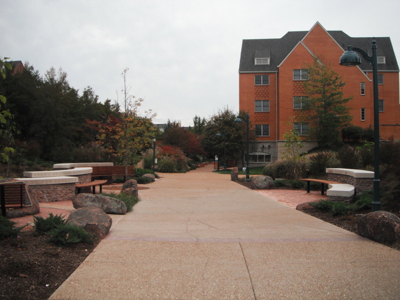
profile (and best-loved) of Indy’s murals is a giant recreation of Kurt Vonnegut, looking about as avuncular one could ever hope from the city’s most lovable curmudgeon.

In fear of seeming like too much of a killjoy, let me defend the mural not just for its great attention to detail, the formidable skill of its creator, and its unquantifiable boost to the city’s self-image by reminding the world that it was the boyhood home of one of the 20th century’s most respected satirists and social critics.  Hopefully Kilgore Trout would approve of my cynicism, though, when I follow this paean with a serious disclaimer.  Doggone it, this mural has Kurt beaming onto a parking lot along Massachusetts Avenue, a fashionable yuppie nightlife corridor that will inevitably turn into a mixed-use development eventually, shrouding the gargantuan Vonnegut into a back alley.  The salience the mural enjoys now from emptiness of the parking lot will eventually lead to its downfall—or, at least, its almost complete concealment when a building sprouts up.  (Then again, Kurt, ever the rake, may just as easily have approved of such a self-defeating gesture.)

But this Vonnegut dilemma hints on a recurring problem with many murals: the conceivers deliberately place them on blank walls that probably wouldn’t exist if it weren’t for the adjacent building the faced demolition years prior.  Such is the case for many of the murals in Philadelphia, as well as this earlier mural (predating the Super Bowl) that I blogged about a few years ago.  Too many murals serve as unintentional placeholders, beautifying a featureless flat surface until something else comes along that is far more likely to stimulate economic activity in the area—and, yes, that “something else” nearly always translates to a new infill development.

Michigan’s largest city can claim its own artistic ammunition, boasting a variety of sculptures and murals, both amateur and professional.  I’m not sure if Detroit’s murals emerged under a centralizing organization in the same way as the murals of Philadelphia or Indianapolis—after all, the city appeared at one time to have a Detroit Mural Factory that trained students in the practice, but I cannot find a centralized webpage with up-to-date information for this Mural Factory.  At any rate, the existing array of murals certainly offers a powerful contrast within a city that, by most empirical assessments, suffers a higher-than-average problem with graffiti, when compared to other American cities.  And though graffiti is far less common place across the American landscape than it is in most other countries, Detroit seems to have more than its fair share, no doubt due to the higher concentration of vacant, neglected or underutilized buildings.

So it is with no small amount of comfort that I recognize a highly effective mural that sits on Woodward Avenue, one of the city’s prime arterials, just south of Warren Street, in the heart of the Wayne State University campus.
Whatever one might think of the mural’s broader aesthetic ambitions, it certainly adds color and texture to an otherwise monochrome flat surface.  It’s big—possibly bigger, all in all, than the lanky Vonnegut in Indianapolis.  But it shares the same predicament: it rests on a blank wall to a building whose kissing cousin came down years ago.  In its place is this big grassy lot.
And the lot is expansive—huge.  Here’s looking at it from the other direction (northward) along Woodward:
And pivoting a little bit to the left, in a northwesterly direction:
Not surprisingly, a city that has suffered as much extensive depopulation and disinvestment as Detroit has more than its share of vacant lots, the verdant reminders of mighty Art Deco buildings that once lined this corridor.  In many quarters of the city, the urban prairies will likely sit there for years to come.

But not here in Midtown, and certainly not on Wayne State’s campus.  Leadership at WSU has pushed significantly to shift its prevailing identity over the years.  Since its founding as a medical school and training college, the university has burgeoned and evolved into Michigan’s third-largest.  But it has rarely (if ever) claimed a significant presence of live-in students.  Long a commuter school, the reputation—particularly in Detroit’s darkest days of crime and disinvestment—was that students at WSU drove to the university from the suburbs, took their classes, and got out by dusk.  Throughout the 1990s, the campus did not even offer dorm living.  Though the transition is undoubtedly a bit more nuanced than I’m portraying here, the University’s leadership and economic development arm realized that the chasm between the school and the surrounding Midtown neighborhood was only growing.  And it certainly wasn’t helping the desirability of being a student at Wayne State.  As a result, the school has engaged in a flurry of both dormitory construction and partnerships with developers to encourage a greater student life around the campus that lingers after hours.  Consequently, Midtown has as bustling pedestrian scene that was scarcely visible 20 years ago.  More eyes on the street translates to greater perception of safety, and the presence of a youth culture with some disposable income has spurred a concomitant college-town retail scene.

This broad scythe at a history of Wayne State’s involvement in Midtown inevitably cuts some corners (pun intended), but in the long and short of it is, it’s only a matter of time before this grassy corner at the intersection of Woodward and Warren will host a new building, if not several.  And it’s equally certain that, in due time, a developer seeking to maximize the FAR (floor-area ratio) on the parcel will want to build in very close proximity to the existing building with the mural.  The developer may even choose to touch the adjacent structure.  Which means that this elegant adornment could fall into oblivion, frustrating not just the artist but also the community support that helped to conceive it.

Fortunately, the minds behind the mural have an ace in their sleeve.
Notice the tiniest shadow at the lower left corner of the mural?  That’s right—it’s not directly painted onto the wall.
It appears to be a sort of canvas that has been stretched to tautness through tying its corners to hooks implanted in the mortar between bricks.  I suppose, if we’re purists, this means that this piece of artwork no longer fits the traditional definition of a mural.  But it will likely fake anyone who isn’t scrutinizing.  And, more importantly, it means that the canvas can come down when a building goes up next door, then get installed somewhere else.

From an artistic standpoint, my suspicion is that this display has lost a bit of credibility.  After all, it didn’t require an artist’s careful assessment of the space, nor the dedication of applying paint to a rough surface from a vertiginous position.  Though clearly “drawn” as an original, it’s quite possible this canvas’s existence depended upon a digital magnification.  So maybe it’s cheating.  But the fact remains that neither WSU, future developers, nor whatever arts program finally implemented the “mural”—none will have to witness the demise of this work of art in a few years.  The same can’t be said about Kurt Vonnegut in Indy, nor the hundreds of murals emblazoned on blank sides of buildings in Philly.  Migrating this canvas to another big wall should seem like a minor effort in comparison, and in a city that has witnessed so much renegade art in the wake of its abandonment, the citizens will finally get to see a painting salvaged, as welcomed new construction fills the void.

Sunday, January 13, 2013

Sustainable Mayberry.


Impeded by byzantine zoning regulations, compliance with historic preservation standards, or anti-density community activists (aka NIMBYs), infill development is typically challenging enough to implement in an urban setting.  Auto-dependent cities in America—which are the majority—remain littered with parking lots wedged between two older, surviving structures that pre-date the car.  Those lots serve as a reminder of the venerable old buildings that once stood in their place.  When cars emerged as the primary means of getting around by mid 20th century, finding an easy place to park often became more critical to downtowns than retaining the buildings that had long been the primary downtown destinations.  Today, after much maneuvering and militant compromises from the original vision, developers have succeeded in filling in some of the gaps in the downtowns of the more economically healthy cities, particularly those that have recrafted their city centers as a hub for entertainment and fashionable urban living.

But what about the small towns?  Most of their downtowns suffered at least some of this spot demolition in order to accommodate car parking and to compete with the mega-markets that ran roughshod across the cheap land near the outer highway (Wal-Mart being the favorite culprit).  But only a select few of these small downtowns have enjoyed any sort of economic renaissance; even fewer have stimulated new infill development.  Will these towns ever fill in the gaps, and, if so, how?

The community of Oberlin, Ohio, about 35 miles southwest of Cleveland and with a population of 8,200, might offer a solution.  It seems to have defied conventions.  It’s not the seat of Lorain County, so it cannot ascribe to the Midwest prototype of a central courthouse square surrounded on all sides by commercial buildings.  But it does have an easily identifiable old commercial center.


The shape of Oberlin’s downtown demonstrates another method by which it bucks the trends.  Unlike most towns of its size, it does not consist exclusively of a linear-oriented main street.  The map below highlights the presence of commercial buildings in the town, using the purple outline.

While the epicenter of Oberlin’s small downtown clearly sits at the convergence of College Street and Main Street, the configuration is unusual.  The commercial buildings like the one featured in the top photo do not spread evenly in each direction to form a cross or a plus sign; rather, the buildings only stretch to the south side of the College Street axis, essentially forming a T-shape.  One block of South Main Street contains commercial and civic buildings on both sides of the street, as seen in the photo below:
Meanwhile, College Avenue’s commercial corridor only rests on the south side of the street, which includes buildings such as these:
But a pivot to the northwest at the intersection of College and Main presents the following view:
It’s Tappan Square, a centrally located park.  The Google Streetview provides a wide-angle perspective which shows the main-street typology depends exclusively on one side of the street.  It wouldn’t be the first pedestrian-oriented commercial corridor to succeed despite a lopsided axial development pattern: Bexley, Ohio, which I explored extensively in the past, features a thriving commercial artery on the north side of East Main Street and, along much of the south side, the greenery of Capital University.  So does Nassau Street in Princeton, New Jersey, from where I have written much of this essay: the north side is a very upmarket retail district; the south side is Princeton University’s primary campus.

If isn’t obvious already, Oberlin’s tiny downtown offers a similar dichotomy.  In this case, the north side of College Street hosts the campus of Oberlin College, the esteemed liberal arts school that assures this municipality a high-profile cultural role belying its small size.  And single-loaded commercial corridor phenomenon might also explain this streetscape about a block east from the town’s core intersection, along College Street:
The building in the center of the above photo caught my attention, because it was clearly much newer than the adjacent building (to the right in the pic), as well as pretty much every other building in Oberlin’s central commercial “T”.  What was its story?  I made my first assessment based on its appearance alone.  As buildings in downtown Oberlin go, it’s big.
It smartly abides by the urban design typology of its kindred downtown buildings, encouraging retail on the ground floor through the accommodating fenestration, while reserving upper floors for other uses.  The photos above confirm the considerable width of the building along the College Street frontage, but it extends southward as well:
The back of the building could easily have assumed the obvious butt-end function reserved for parking, mechanics, or garbage collection, all presided over by a featureless wall.  But it doesn’t. The architects have programmed the alley space behind the building into an interior courtyard.
A smaller, ancillary building featured in the second of the two photos helps enclose the space, shielding it from the unsightly parking lots that predominate the backsides of neighboring buildings, like this example:
I also appears that the designers have cushioned the space between the sidewalk and the street with some enhanced landscaping.
Judging from those thick thirsty grasses, the greenery here should help capture and absorb stormwater runoff, putting it to more productive use than in the municipal storm sewers and preventing it from flowing back to the watershed in a more polluted form.  The landscaping offers both street-level aesthetics and an environmentally sensitive alternative to all the paved imperviousness around it.  Lastly, the building’s retail frontage seems to welcome bicyclists…
...though perhaps still not quite enough, since the myriad bikes parked on the day I visited almost evoked Copenhagen more than an American college town.

From my own non-expert evaluation, this is a smartly designed complex, not out of place in a trendy district of a major metropolitan area.  But somehow it ended up in little Oberlin.  And, to top it off, it is obviously an infill project.  I patronized Café Sprouts, a vegan deli, bakery and juice bar on the first floor, to see if I could get more information.  One of the employees informed me that the site had hosted a drive-thru Rax Roast Beef restaurant in the past, but it had been vacant for years and had reduced that arm of the downtown “T” to a dead zone.  The current Google Streetview, from September 2008, perfectly captures the “before” vision, when site planning for the infill development had just begun.  The employee also pointed me to a sign I had up to this point somehow overlooked:
This told me everything else I needed to know.  It took no time at all to find a bevy of articles, such as this one, to get even more background on the project.   Three relatively recent Oberlin grads formed a development partnership called Sustainable Community Associates just blocks from their alma mater.  Their goal was to inject life into a long dormant corner of downtown with a high-density, mixed-use, mixed-income development that also employed environmentally sustainable practices.  The $15 million result, with 33 condos and 20,000 square feet of retail, is seeking LEED-Neighborhood Development Gold status and hopes to stimulate further densifying infill in Oberlin where the opportunities arise.

Needless to say, I was taken by this project, which I had inadvertently stumbled upon during an impromptu first-time visit through the town.  It’s enough to marvel at how it achieves a superior urban design configuration to 90% of the new developments that have taken place in my hometown of Indianapolis in recent year.  (To an extent, that is a subjective judgment call on my part.)  What’s less open for dispute is that such infill is virtually unheard of in towns of Oberlin’s size.  Surrounded by cornfields in all directions, it is close enough to Cleveland to fall within the metropolitan area, but still too far to qualify as a suburb or even a reasonable exurb.  But the town owes most of its idiosyncratic character to its adjacent college, whose history of left-leaning political activism competes broadly with its reputation for academic excellence.  While it certainly helps that the brains behind Sustainable Community Associates went to school there and no doubt forged strong connections to the community, it’s not every Ohio town that can muster support for a sizable new LEED certified building, let alone one that accommodates bicycles more visibly than cars.  But most small towns in Ohio also wouldn’t support a vegan bakery/juice bar called Café Sprouts.

The symbiosis between the developers and the small, like-minded community helped transcend zoning stipulations or not-in-my-back-yard obstructionists.  It is hardly surprising that college towns like Oberlin, regardless of their size or the character of their rural purlieus, often prove the most successful laboratory for experimentations in infill.  They might offer a smaller canvas on which to operate, but they generally benefit from a more homogenous population and a smaller artillery of regulations to thwart the savvy designers’ visions.  I am fully confident that another five years will introduce to Oberlin a similarly chic infill project.  And I won’t be at all surprised if I find a Kabbalah Center in the retail on that first floor.

Monday, October 8, 2012

Tending the student flock.


With any urban infrastructure project dedicated exclusively to separating pedestrians from vehicular traffic, the benefit is typically a double-edged sword.  While the investment may allow pedestrians to cross on their own volition at any point in time, it also expedites the flow of traffic at higher speeds through what could be a pedestrian-dense area.  Instead of improving the ability for foot-travelers and wheels to engage more harmoniously, it forces them into non-engagement.  Any prudent public works project aims to improve the level of service for as many modes of transportation as possible, providing an aggregate net benefit while, to cull from the Hippocratic oath “primum non nocere” (first, do no harm).  Obviously not every transportation enhancement meets all of these ambitions, and all too many meet none of them.  But a radical earth-moving initiative that places pedestrians and vehicles at completely different altitudes will at least induce a formidable change on the landscape—whether the change is necessary or even positive requires evaluation of an individual project’s merits.

The average university campus is a often a wonderful laboratory for pioneering innovative means of traffic management or transportation enhancements: they usually have the combination of an on-site residential student population that is heavily dependent on the two feet for getting around, coupled with a high concentration of jobs that draw vehicle-dependent commuters over a broad radius.  Many universities in urban settings are also benefit from proximity to major transit stops.  Washington University of St. Louis is no exception.
Straddling multiple political jurisdictions, virtually any major street improvement project will inevitably encounter its share of hurdles in terms of financing and implementation.  While the majority of the Danforth Campus (primarily undergraduate) rests within unincorporated St. Louis County, portions of it sit within the municipalities of Clayton and University City; the actual City of St. Louis only contains a small fragment.  The Forsyth Pedestrian Underpass pictured below ostensibly underwent extensive repairs earlier in the year, with costs split between a federal grant and Washington University.
It provides completely protected, ADA-compliant access under Forsyth Boulevard, at the approximate location indicated by the blue rectangle in the map below.
More than half of the Danforth Campus sits on the north side of the road, but a considerable expansion continues south, including the majority of the residence halls.  No doubt this is a heavily traveled passage, and by most metrics, the design appears effective.  Here’s an approach from the north side of the road, heading through the parking lot southward toward the underpass:
Just a bit further, with the underpass in sight:
And pivoting to the left, another ramp that connects directly to the sidewalk along Forsyth.
A fairly obvious but nonetheless smart decision was the inclusion of visual elements that enhance underpass beyond its utilitarian aims.  For example, the walls in the tunnel serve as a series of rotating murals, promoting events (provocatively at times) that will soon take place on campus.  No doubt the displays here change monthly, if not more frequently.
And then, continuing through the underpass and looking behind, the sculptural display (a blue sphere, among other things) through the tunnel.
Had the underpass lacked these colorful flourishes, it would be inevitable that some vandal would insert some on his or her own.  Murals, no matter how crude, have an uncanny ability to deter graffiti artists, who more often than not seek an unmonitored blank canvas.  If graffiti were to accumulate along the Forsyth Underpass, it would immediately convey a sense of insecurity to many users; more likely than not it would encourage other acts of vandalism and perhaps eventually more serious displays of criminality, operating under the elementary tenets of the Broken Windows Theory which I have blogged about in the past.  Another recurrent problem with underpasses, particularly if they are long, is that the absence of natural light renders them shadowy and uninviting, leaving dark corners that could encourage urination or public indecency at best and assault at worst.  Pedestrian advocates typically shy away from underpasses, primarily because they can engender more safety problems than they solve.  The engineering behind the Forsyth Underpass at Washington University seems mindful of the primum non nocere standard: not only does it achieve core functionality, but it also can be informative and aesthetically pleasing.

Despite its general success against many odds, I can’t help but think that the attention to certain details with the Forsyth Underpass also help to shroud its intention to exert a high level of control on its users.  For example, on the south side of the road, pivoting away from the underpass and looking further southward, this is what the pedestrian sees:
For all intents and purposes, it’s an attractive, heavily landscaped path toward the university’s dorms.  But look to the left:
And a bit further:
Either shrubbery or a fence makes it impossible to climb that hill to access the sidewalk on the south side of Forsyth Boulevard.  And it is the same way when one pivots to the right:
I’m clearly looking a bit backward here too, with the road above.  But still no access.  Even if those fences are a temporary installation (the City of Clayton Public Works website does say that peripheral work will continue into the school year), the construction has provided no paved paths to access this side of the street.  It is almost as though the underpass is funneling students directly toward the dorms rather than allowing them to walk along the road.  Contrast this with the northern side of Forsyth Boulevard, where the ramp provides direct access to the street.  From below (as seen before):
And at the top of the ramp (the railing is visible on the far right):

Why is the design of the underpass forcing the students/pedestrians onto a certain path?

That’s not the least of it.  The engineering to the underpass is commendable for not stretching the tunnel to the point that it would be shadowy.  But wouldn’t it be hard for the tunnel ever to be long, considering the width of the street above it?  The previous photo reveals what should be obvious already: Forsyth Boulevard isn’t even a very broad street.  Here’s looking at it perpendicularly southward, with those dorms in the distance:
 
And pivoting a bit to the left:
Only three lanes wide.  Was this really a busy enough arterial to justify separating the pedestrians?  I don’t have traffic counts, but a road of this width couldn’t handle more than moderate levels.  It’s only a collector street cutting through a campus, so maximum speeds will never be high.  It seems even more ridiculous to install an underpass, after considering that a conventional at-grade crosswalk sits just a half-block further to the east:
There it is, at the stop light in the distance.  Pedestrians could just as easily cross there, without having to make unnecessary turns to maneuver the grade change of a ramp and underpass.

Was this underpass really even necessary?  Obviously I don’t know the full political implications at play, and with the Washington University campus straddling so many different boundaries, it is possible that quite a few parties were involved in the negotiation.  But the visual evidence increasingly suggests that the Forsyth Underpass is less of an amenity for students and more of a means of discouraging any pedestrian interference with vehicular traffic.  If this mid-block point is a popular means for students to cross from the dorms to primary academic buildings, wouldn’t a simple guarded, signalized crosswalk have been a much cheaper deterrent to jaywalking?  The only conclusion I can draw is that the installation of this underpass exclusively favors vehicles, preventing them from ever having to stop at anything other than intersections with other roads.  Aside from the fact that pedestrians at the underpass don’t have to wait for traffic to clear in order to cross, it otherwise impinges upon their options.  Like the fence at the crosswalk along Chicago’s Michigan Avenue that I observed a few years ago, this expensive public works initiative prioritizes wheels over feet.  University City, Missouri is, by and large, a pedestrian friendly environment (it also has good St. Louis Metrolink access), and it should be, with all those students.  But the deficiencies still abound, proving how difficult it is to unlearn old habits from nearly a century of placing the car at the top of the cultural pecking order.

Tuesday, June 26, 2012

Economizing and downsizing a city’s landmarks.


When navigating through an unfamiliar place, either urban or rural, we tend to seek visual points of reference to aid us in further wayfinding.  It is as instinctual of an action as folding the corner of a book.  Across the countryside, visual cues assume a variety of incarnations: a distinctive geological form, an unusual sign, an anachronism (particularly old-fashioned or unexpectedly contemporary), or an anomalous color or shape.  Rural reference points are frequently large, nearly always tall, but only occasionally are they part of an intentional effort to “stand out” as an explicit reminder of a particular location.

By contrast, urban reference points are nearly always manmade and deliberate, sometimes bordering on the point of ostentation.  In his famous 1960 book, The Image of the City, Kevin Lynch includes landmarks among his five fundamental elements people deploy in order to assimilate visual information that helps them navigate in an urban setting; the other four elements are edges, paths, nodes and districts.  Landmarks may be the least subtle because they are particularly geographically contained—neither linear nor planar and thus essentially uni-dimensional.  Distinctive height and appearance usually endow an edifice with an advantage as a landmark: it could be the tallest feature in a city, or, in a metropolis with numerous skyscrapers, it may simply be a monument of considerable size with a unique appearance.

In most Midwestern towns and smaller cities, the landmark fits both of these characteristics: namely, the architect conspired to give a certain structure both superior height or massing as well as a distinctive look.  It should come as no surprise that these landmarks tend to be county courthouses: in Indiana, Ohio, and just about anywhere else in the former Northwest Territories, the courthouse occupies the town’s central square, surrounded by other commercial buildings on most, if not all, four sides.  (The only exceptions are when the county/community is too small to justify enough commercial buildings to surround the square, or when town leadership has demolished a preponderance of these aging structures.) The clock tower, spire, or cupola typically ensure that the courthouse will be taller than anything else in the community, augmenting the building’s visual prominence and transforming the square into the town’s unquestionable center—the “node” by Lynch’s definition.

Anyone with more than a passing familiarity of Indiana landscapes can envision a county seat with its venerated central courthouse square.  For me, Crown Point, Greensburg, and Noblesville are among the first that come to mind.  However, despite being larger than any of the aforementioned cities, Muncie does not have a courthouse square that embeds itself in the typical visitor’s memory.  For the time being, this image from Google Streetview of the Delaware County Courthouse will have to suffice.  If this structure fails to convey the conventional image of a Midwestern county courthouse, that is quite obviously because it isn’t one.  The 19th century building that housed most Delaware County government functions met the wrecking ball in 1966, replaced shortly thereafter with this structure, now the Delaware County County Court administrative offices.  Here are some recent photos I’ve taken at approximately the same southeast corner, showing that landscape architects have spruced up the grounds since the above Flickr photo was taken, reducing the imperviousness of the plaza by adding rainwater gardens and a prominently located state/national flag.


By most estimates, it’s still not a very inspiring structure.  I’m hardly one to denigrate all of the brutalist architectural influences that this contemporary building evokes—after all, Muncie’s First Merchants Plaza is, in my opinion, a respectable brutalist building--but it’s hard to summon a great deal of love across the web for the new building: a simple Google Images search reveals far more links for the 19th century building that formerly stood at this site.   Quite simply, hardly anybody even cares enough about this building to photograph it.  And the actual courthouse, now called the Delaware County Justice Center and sitting a block north of this concrete structure (which is the actual original site for the historic courthouse), is hardly any better.


It, too, seems heavily fortified and uninviting, though at least it make some sense: this building also hosts the county's jail.

Aside from brutalism’s obvious precipitous fall from grace by the mid 1980s, what else is wrong with the first of these two buildings, which stands at Muncie’s implicit dead center?  Even with the flagpole or landscaping, it doesn’t convey the monumentality needed to make an identifiable landmark: not only is the court admin building the same height or smaller than some of the surrounding structures, the fenestration is fundamentally introverted and uninviting to passers-by.  The massing of the upper floors obscures any first-floor entrance in the shadows, so that the plaza is the only way to discern that this might be the building’s façade.   Not only does this new court lack a prominent apex that could attract the eye from a distance, but its intrinsic reticence nullifies any grandeur that could at least turn the courthouse plaza into a central node.  Here’s a view from the western side of the building:

Nothing more than a blank wall.  No lawn, no sculptures, no flags.  Visitors could walk or drive right by the courthouse without even noticing this building, and as a result, Muncie lacks the perceived core to its downtown that we have come to expect in most Indiana county seats.

The next contender for a central landmark, Muncie City Hall, built in 2005, achieves a certain stature as it looms over the bridge to the White River, directly to its northwest.

But it only functions as a hub by proxy: it is the next best thing, given the absence of the prominent central courthouse that visitors would expect.  Where does this leave a city in search of a landmark?  The Shafer Bell Tower at Ball State University certainly could function as a rallying point within the campus, but this relatively new structure belongs to the university, both de jure and metaphorically. 
It is virtually meaningless to the at least 60% of Muncie residents who have no affiliation with the school.

Not surprisingly, the community itself has attempted to place the crown on what it perceives to be the city’s presiding head, and two of the strongest contenders are particularly ironic.  The first, the Muncie Pole at the intersection of S. Tillotson Avenue and W. Jackson Street, has its own Facebook page, a Twitter feed, and it received media attention from as far away as Texas--all of it due to an engineering mistake during street and sidewalk improvements.  The utility pole actually sat in the right-of-way, with three reflective strips emblazoned along the lower part of the stanchion to keep vehicles from colliding into it.  Sure, Muncie has dozens of other poles to hoist traffic lights, but when locals referenced “The Muncie Pole”, everyone knew which one they were talking about: The Pole had earned its capital letters.  It was a landmark in itself, at least to the locals, and, due to its distinctiveness in a landscape that lacks prominent features, it may very well have stood out enough that visitors unfamiliar with Muncie could use it as a spatial mnemonic device.  The Muncie Pole gets the past tense treatment though; within the last month, city engineers and the public works department corrected their error and the pole was removed, leaving only a conventional traffic light pole, shielded from traffic by a grade separation and curb.  

Another oddly situated traffic light in the city may already qualify as a successor to the Muncie Pole, inheriting the name from its predecessor as it becomes this city’s most effective landmark and reference point.


Seeing a utility pole shellacked with postings is hardly uncommon, but this one doesn’t include want-ads, solicitations, meeting locations, missing pets or miracle weight loss strategies.  It’s devoted almost exclusively to decals reflective of the local “scene”, a region extending out to and including Indianapolis.  Local bands, festivals, breweries and non-profits all feature heavily.  Semantically, the content of this pole is a world apart from what one might expect to see in such a location: these stickers don’t carry precise, distinctive notifications intended to mobilize passers-by; instead, they tout brands which, in aggregate, appropriate far more visual significance than they would in isolation.  The pole is a repository for alternative culture—the touch-and-go pastiche approach is critical to its appeal, even as it might alienate others who merely see this as an act of vandalism.  (Eliciting a polarizing response is nearly always a good thing—fewer people are ambivalent, and the display thus becomes more memorable.)  While the earlier Muncie Pole earned its meme status through a variety of exogenous referential material (Twitter and Facebook, inter alia), this pole is a meme because of what it possesses and displays: that is, hands that have slapped the metal with adhesives have enhanced its role as a cultural signifier.

But why is this specific pole a contender for the NEW Muncie Pole when alternate poles abound?  What makes it so special?  It helps that it’s in a central location, near the heart of downtown Muncie.  But why not another downtown stop light pole?  Yet again, this pole earns its distinction through a probable error in calculating the point of installation, which is manifested by stepping backward several 

Usually a stanchion for a traffic light sits closer to the corner of the block; not at the halfway point of a storefront’s primary window.   Pivoting a bit to the right—
--it doesn’t remotely align with the handicapped ramp that connotes the crosswalk location.  It strangely hugs the building instead of the curb.  My estimate is the more practical location would be directly to the left of the manhole cover that sits closest to the building’s cornerstone.  But it clearly wasn’t meant to be.
The photo above suggests that the complementary pole on the other side integrates much better with the streetscape: it sits on a bulb-out in the sidewalk and enjoys a reasonable setback from the structure at this corner.  In fact, the photo below shows that this pole does not impinge upon either a building view or a pedestrian right-of-way along the sidewalk.
 
This pole--coincidentally in front of the bland, windowless court administration building--also lacks any of the stickers; it’s just another pole in Muncie, but certainly not the Muncie Pole.

The pole in front of Savage’s Ale House has already achieved enough salience in a small city like Muncie that it functions as a minor downtown meme.  If Ball State University students decide that it is the ideal point of reference downtown (“Let’s meet at the pole and decide where to go from there”), then it has, in the context of Kevin Lynch’s urban semiotics, essentially become a landmark—the substitute for the Delaware County Courthouse demolished decades ago, and ironically standing directly across from the forgettable modern courthouse of today, as the photos indicate.   Here below, is a view looking northward, with the intersection featuring the New Muncie Pole in the background and the modern Delaware County Courthouse in the foreground to the right.
And here's a close-up on the building with the Muncie Pole.  Although on the left in the above photo, in the photo below the three-story building is in the center.


Urban landmarks tend to include at least a little bit of architectural bombast; normally they are very deliberately the most prominent visible element from the built environment.  The architect intended nothing less than a centerpiece.  The Muncie Poles (both the deceased one on Facebook and its slightly more urban successor) owe their existence to what is most likely an unconscious err in calculation, but that is enough to make them an anomaly in a landscape riddled with sameness.  And for Muncie, a previously mundane metal pole has the potential to become the epicenter of pedestrianized student culture…at least until one of those sites of former buildings that are now parking lots becomes gets developed into bigger, better, more visually distinct landmark than a stop light post.  Economy notwithstanding, a hip, stickered pole shouldn’t be tough to outdo.