Showing posts with label New Jersey. Show all posts

Thursday, July 31, 2014

Who knew that the City That Never Sleeps had a narcoleptic neighbor?


As I prepare for some upcoming significant changes to my blog, I provide a sort of “placeholder” article as make the final modifications, which I will soon publicize.  The placeholder motif extends to the content of this blog entry, where a window sign serves much the same purpose within its respective storefront.

It’s simply announcing a lunch special.  The restaurant itself?  As indicated at the top of the sign, it’s Bertucci’s, an Italian chain common in the northeastern US.  Though the restaurant’s target market is consistently suburban middle class, it seems as though Bertucci’s restaurants routinely occupy urban settings, in storefronts that directly face the street, rather than a sizable parking lot.  Such is the case with this location.
The sign itself isn’t really remarkable on its own terms.  The only thing that distinguishes it is a condition that these photographs could not begin to capture: the day of the week.  The advertisement for this lunch special is taking place on a Saturday morning, and it’s a good deal: good enough to suggest that this Bertucci’s is struggling to get people in the door on a quintessential weekend day without some real incentive.

Is there something wrong with this Bertucci’s?  Probably not, at least in terms of management and menu—after all, it’s a chain, and if chains lose their consistency for too long, they croak.  So why is this one deserted?  It might have something to do with its surroundings.
The translucent sheen of the contemporary buildings that flank this Bertucci’s comprises one of the busiest commercial centers in Jersey City, New Jersey—just a stone’s throw across the river from New York City.  The Garden State’s second largest city (just behind Newark), it’s also old, settled as a garrisoned Dutch village in the middle of the 17th century. Yet you’d hardly be able to tell from looking at its coruscating skyscrapers in the Newport neighborhood, seen here in the photos, as well as Exchange Place, directly south of Newport along the waterfront.  It all looks like it could have been built last week.

But the focus for this blog is the larger Newport neighborhood.
Constructed across 600 acres on the old Erie Lackawanna Railway yards, Newport helped galvanize Jersey’s City’s resurgence after its 1986 groundbreaking.  Built as a master-planned, mixed-use community, the intent of its creator, Samuel J. LeFrak of The LeFrak Organization, was to intermingle high-rise residences with office, retail, and entertainment facilities.  The site capitalizes on its pivotal location, adjacent to the Holland Tunnel (with direct vehicular access to Manhattan), as well as I-78 and, not so far away, the New Jersey Turnpike. Newport is also easily accessible by the Hudson-Bergen Light Rail, PATH, New Jersey Transit bus routes, and a ferry service across the Hudson River.

In other words, this is prime grade real estate.  And, by most metrics, it has transformed into a successful locus of commerce, while over a dozen apartment towers house the neighborhood’s approximately 15,000 residents.  By the 25th anniversary of Newport’s establishment, the high density community also boasted a marina, 
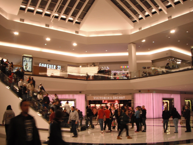
waterfront parks (one with a beach), two hotels, schools,  and the Newport Centre Mall, a regional shopping center whose retail mix ostensibly caters to a broad and diverse socioeconomic base, spread across over 1.1 million square feet and three floors.  This Simon-managed mall also sits squarely within Jersey City’s Urban Enterprise Zone, thereby halving the sales tax rate on goods (only 3.5% instead of 7%) and waiving it altogether for clothing, which no doubt has helped cushion it from the steep decline so many malls across the country have faced.

But for all its amenities, Newport does not seem to have yet mastered the art of fostering a vibrant streetscape.
Sure, there are some people out.  And more people might have been impelled to stroll Washington Boulevard if it weren’t for the blustery conditions on an otherwise mild April morning.  But the fact remains that Newport has metamorphosed into a district with a high concentration of activity in an already active city (Jersey City’s density is well over 15,000 people per square mile, ranking it among the 30 most dense American municipalities).  Nonetheless, this Bertucci’s, sitting right on the neighborhood’s main arterial has to devise special sales to attract visitors to a weekend lunch.  This restaurant’s valiant effort to lure customers only serves to reaffirm what empirical evidence already suggests: that Newport is only lively from 8a to 6pm on Monday for Friday.  Then it hibernates.

The two sons of the late developer Samuel LeFrak strive to continue to his legacy through the family business, but they also hope to improve upon some of the past architectural missteps.  Visual evidence confirms that, aside from the spectacular views of Manhattan from the waterfront, Newport is generally not a terribly desirable setting for people to get out and walk around.  It doesn’t help that ungainly, austere parking garages sit between the occasional storefronts.
Or, for that matter, that one of the primary hotels fronting Washington Boulevard includes a big enough setback to allow for considerable vehicle loading/unloading, as well as some spaces for off street parking.
Obviously, the majority of American hotels—including those in our city centers—include these exact same driver-friendly features.  But the vast majority of American cities cannot boast the sort of multi-modal or mass transit access of Jersey City.  Such a configuration would be virtually unthinkable in Manhattan, and, to this day, even many smaller American cities—often with significantly weaker transit systems—would still include zoning stipulations that vociferously discourage off-street parking lots for hotels within the central business district.

Perhaps, however, the biggest hindrance to Newport ever succeeding as a round-the-clock active urban district is the land use just two blocks away from this photo series.
As Washington Boulevard continues northward of Newport Parkway (the road that rests directly above the Holland Tunnel to Manhattan), the vista changes completely.
Gone are the highrises, replaced by a series of suburban-oriented big box stores (Target, Staples, Best Buy) and replete with off-street parking lots.  The map below shows that this area in Jersey City offers a host of shopping options that one would just as easily expect to see in an automobile-oriented suburb.
Incidentally, this cluster of big box retail sits just south of a huge rail yard, easily visible on the map.  And north of the rail yard is the border for Hoboken, another densely populated waterfront suburb, but one with a vibrant commercial main street, filled with retail and pedestrians at all times of day.
(And, somewhat ironically, Hoboken’s thriving commercial corridor is called Washington Street—a contrast from Jerseys City’s inert Washington Boulevard.)

To be fair, Newport is hardly the alpha and the omega when it comes Jersey City’s retail centers.  The historic downtown to the west of the waterfront consists primarily of two to four-story 19th century buildings, with numerous street-level storefronts along Grove Street and Newark Avenue.  Many blocks in the older, “real” downtown of Jersey City boast an activity level on par with Hoboken.

If anything, the uninspiring streetscapes of Newport most likely reflect the mindset driving development during the time of the district’s founding.  Back in 1986, when the LeFrak family’s vision first started to take root, much of Jersey City was down on its luck, having left the doldrums of the 1970s in its wake—a time when the city lost a staggering 14% of its population.  At that point, this inner-ring suburb of New York City had been shrinking ever since the Great Depression.  Though a far cry from its 315,000 peak, it has posted an increase in population for the last three decades.  But no one could have anticipated that in the 1980s, when The LeFrak Organization took a chance by purchasing land in a district of dilapidated warehouses amidst a field of creaky, neglected railroads.  At a time when even Manhattan’s future appeared murky, suburban living still seemed like the solution, so it comes as no surprise that the land uses surrounding LeFrak’s bold move still reflect the demands of a mostly suburban clientele.  The mall, the bargain department stores, the wide streets, the visible parking lots—all of these in the 1980s seemed like essential gestures to attract a population seemingly incorrigibly averse to urbanism.

The times are changing, but the remaining boxy Staples and Best Buy, monolithic amidst their generous parking lots, feel more like the final unpainted portions of a canvas, rather than a byproduct of lackadaisical urban design.  By this point, Jersey City’s escalating land values promise a higher and better use in the near future, particularly for a struggling national chain like Staples.  If the chain folds, it’s a matter of time before a savvy builder puts something with a higher Floor-Area Ratio in its place—that is, a taller building that yields a higher rate of return.

In the meantime, until the stronger economy forces developers to strategize on their urban design, Newport will continue to limp along.  It’s still a killer place for an office, and I have no doubt that Bertucci’s can fill its tables during a Thursday lunch.  But this abundance of youthful skyscrapers in an environment that remains steadfastly car-centered looks less like a satellite of New York City and more akin to Dubai.  (Or, at least, everything except the historic center of Dubai, which still remains pretty pedestrian friendly.)  No matter how great the density of jobs and residents, no matter how robust the mass transit, the fundamental character of the buildings and streetscape in Newport does not lend itself well to pedestrianism.  What it does yield, however, is a perfectly extreme application of urban transect modeling, in which the form skips several typological layers, going directly from an urban core zone (in the heart of Newport) to a suburban zone north of Newport Parkway, where the Staples first appears.  But Newport’s atypical renaissance places it at odds with most theories on urban form, even if the results are less than meets the eye.  If the developers make sharper decisions as they continue to invest in the area, maybe sometime they’ll be able to promote a level of energy to the streetscape that will convince people to walk around.  And Bertucci’s won’t have to deploy placeholder signage to make up for the sluggish weekend business.

Saturday, January 19, 2013

MONTAGE: Stratification across the river.


Late last year I featured an article on the unusual Oxford Valley Mall in Bucks County, Pennsylvania, a mostly upper-middle income suburban region of Philadelphia.  It’s a distinctive mall because it’s simultaneously both low-rent and affluent: it has such high-end tenants as Williams Sonoma or Swarovski, but it also has Five Below, Dollar Hut, and a number of mom-and-pop establishments that you’d typically only see in struggling or dying malls.  This is unusual, since most malls either assume a uniformly upward trajectory, or they manifest their gradual decline.  Meanwhile, Oxford Valley has a higher vacancy rate than it probably should, especially since one of the four department stores has been empty for several years.  But it’s still attracting new tenants, both fancy and downmarket: Sephora (the former) and H&R Block (the latter) are opening in the mall over the upcoming weeks.  So what’s the verdict on Oxford Valley?  Is it on the fritz or will it persevere?


I’m not from Bucks County and haven’t gotten to witness it over the years, so it’s hard for me to form much of a judgment.  But it’s not the only mall in the area that suffers from this strange split personality.  Just across the river, in Windsor Township, New Jersey, the Quaker Bridge Mall must grapple with an equally uncertain future. 


It’s not far at all: less than 15 miles from Oxford Valley.  Like the Pennsylvania mall, Simon Property Group manages the space.  In fact, the story here is so similar to its predecessor, I’m going to intervene minimally with text and let the pictures tell most of the story.


Quaker Bridge Mall opened in 1975, just two years after Oxford Valley.  Like its Pennsylvania counterpart, Quaker Bridge sits in a mostly affluent suburban area, just a stone’s throw away from Route 1.  It, too, contains over one million square feet across two floors, though Oxford Valley has it beat in size by about a quarter million.  (Quaker Bridge just barely passes the one million mark.)  Both malls feature four department stores, though only Quaker Bridge can claim occupancy in all of them.  The ubiquitous J.C. Penney, Sears, and Macy’s take three of the spaces, while Quaker Bridge’s most prestigious department store is the Lord and Taylor, featured above.


In addition, if one were to judge the affluence of a mall by its interior aesthetics, Quaker Bridge would probably come out ahead.


The shiny, white faux-marble floors and the relative lack of ornamentation evoke contemporary notions of privileged consumption a bit more precisely than the dowdy, middlebrow appearance of Oxford Valley.  To top it off, Simon Property Group (50% owner as well as manager) was investing in a full renovation at the end of 2012.


Apparently, until recently, Simon had bolder ambitions for this property: the company hoped to inject a distinctively upscale vibe through a 600,000 square foot expansion that would include Nordstrom, Nieman Marcus, and about 100 new inline stores and restaurants.  The recession a few years later put the kibosh on those plans, and these days the renovations are a bit more modest: new flooring, ceilings, lighting, signage, hand railings, and landscaping.  And apparently within the past year, Simon leased a newly constructed space to The Cheesecake Factory attached to the mall and widely visible from the parking lot.


The presence of a recognized restaurant chain at Quaker Bridge further enhances its advantage over Oxford Valley; while the Bucks County mall can claim a few outparcel restaurants, none are physically connected to the mall.  A drive around the perimeter of Oxford Valley reveals nothing more than a blank wall; the mall orients itself completely inward.  Simon also has made no announcements regarding any upgrades at Oxford Valley.  Regardless of the scaled-down ambitions at Quaker Bridge, the fact that Simon Property Group has invested in both renovation and new restaurant construction suggests the company’s confidence in the long-term viability in the mall.


All of the above conditions indicate that Quaker Bridge enjoys more auspicious economic forecasts than its counterpart across the Delaware River.  But does it?   To the right of The Cheesecake Factory in the photo above is an entrance to the mall, and as soon as a visitor walks through the doors, this is what he or she sees:


The checkerboard motif coupled with intermittent yellow accents suggests California Pizza Kitchen to me, though if Quaker Bridge hosted a branch of this popular restaurant in the past, it must have folded a long time ago; I can find no online evidence that it existed here.  Across from the old CPK?


The photo featured earlier, with the renovation explanations, also shrouds a huge vacant in-line storefront.  This entire minor entrance corridor is vacant.  Proceeding through this passageway to the mall’s main commercial spine, the vacancies are glaring:


Quite a few on the upper floor as well.  It has reliable tenants, like New York and Company:


And a Hallmark store, which seems to be more prevalent in the Northeast than it does in the Midwest.


The typically commodious Forever 21 seems to be taking a major space in the near future:


But much of the floor is patchy.


That Wendy’s is a real oddity.  It’s all by itself on the second floor—no other restaurants nearby.  In mall milieus, one usually finds a Wendy’s in either the food court or an outparcel in the vast parking lot.  The fact that the Wendy’s is isolated reveals two other leasing hurdles the mall is trying to overcome.  The first of these hurdles is that the mall currently lacks any real food court.


Apparently one is on the way, but, in the meantime, the management has crammed remaining fast-food eateries in an unpleasant passageway leading to another mall exit.


Not much to look at, and the eatery options are meager.  Despite the thick crowds, this hallway cannot attract better tenants than a locally owned convenience store:


One typically only sees the likes of QB Express in seriously struggling malls.  The second of the two hurdles that explains the oddly located Wendy’s is that the mall didn’t need an appropriate tenant at this space; it just needed any tenant.  To put it frankly, Quaker Bridge will take whatever tenant it can get to put a dent in its approximately 20% in-line vacancy rate.


So maybe Quaker Bridge is floundering?  The Star-Ledger article that I cited earlier acknowledged that the mall recently ushered in a slew of new upscale online tenants, such as Michael Kors, Sephora, Teavana, and Sur la Table.  It also can claim the following choosy tenants:


And a few other specialty retailers are on their way:


But the current retail mix does not seem like the type that could usher in a Neiman Marcus.  I was quite surprised to see cash-for-gold store at this mall—a service that spouted like mushrooms about the time of the Great Recession.


And just take a look at the mall’s deadest wing, over by J.C. Penney:


The notion that J.C. Penney would be the least active section of a mall surprised me; after all, most of my mall tours of the past have proven that Sears is the typical Achilles’ heel.  (I blogged about it a while ago.)  But the general profile of the J.C Penney wing at Quaker Bridge is emptiness or unknown mom-and-pop stores.


As far as I can tell, this is the only location in the nation for Pelle and Company.  It doesn’t seem to have a website.  Just a few yards away, Belgium Jewelers reminds me of the sort of retailer one might see in a second or third-tier mall in Dubai:


Peering over the balcony to the floor below, witness another unknown:

The only other location for this mom-and-pop called Rubee?  None other than Oxford Valley Mall.  Rubee doesn’t have its own domain, but at least it has a Facebook page.  Elsewhere on the lower floor are a few more obscurities:


The Grand Fragrances store again looks like exactly something from Dubai of the 1990s.  Another little-known vendor along the J.C. Penney wing seems to have folded.


Meanwhile, Arthur Murray Dance Studio may be a national name, but its reduced hours and relative lack of impromptu visitors makes it an undesirable fit for a major mall.


After all, it was already closing down on the busy weekend night that I took these photos.  Simon Property wouldn’t even consider a dance studio if this mall commanded top-dollar leases.  The bleakest part of the J.C. Penney wing, however, is the cluster of inline stores directly abutting the entrance to J.C. Penney’s itself.


A Payless Shoes in a mall with upscale aspirations?  Not likely.  But J.C. Penney has suffered meager revenues these past few years, and, despite all the renovations taking place at the Quaker Bridge Mall, the management at J.C. Penney’s has apparently postponed updating this particular branch to the new “jcp” logo that is becoming more commonplace.  Then again, since it’s the third logoin as many years, it’s probably understandable that a floundering department store isn’t willing to hedge its bets at a conspicuously transitional mall.


As mentioned earlier, demographics around Quaker Bridge loosely echo those of Oxford Valley: both are mostly upper-middle class suburban areas with large foreign-born populations, which lean poorer in the older urban sections and wealthier in the newer exurbs.  This New Jersey side may be more extreme though: just a few miles away down Route 1 from Quaker Bridge sits the state capital, Trenton, a swatch of intensely concentrated poverty.  Conversely, the neighboring suburbs of Princeton and West Windsor Township far surpass anything in Bucks County, Pennsylvania in terms of affluence.  But Quaker Bridge also hosts a more intensive concentration of retail within a mile radius, because several newish “power centers” (inward turning strip malls) stretch along this same segment of Route 1: Mercer Mall, Nassau Park Mall, Windsor Green, and the Square at West Windsor.  The purlieus of Quaker Bridge Mall offer a ton of shopping options, all of them competitors of Simon Property Group with discrete goals of skimming away some of the choicier tenants at the forty-year-old enclosed mall.


Quaker Bridge might be more worthy than Oxford Valley of a follow-up blog in a year or two; it is, after all, under renovation (albeit a modest one), and it would be interesting to see if Simon’s original vision ever materializes.  At present, though, all the judgments I made in my Oxford Valley article—income disparities, the over representation of malls, and the increasingly diverse consumer base—still apply at Quaker Bridge.  The economic fortunes of these two populous, culturally dissimilar states may ultimately prove the stronger determining factor regarding which (if any) mall prevails.


Tuesday, January 8, 2013

The state house makes the laws; the state takes it for granted.

I’ve observed in the past how, almost instinctively, we come to expect a certain degree of monumentality in major seats of government, usually the prominent display of a central building that hosts those administrative offices.  In the typical Midwestern county seat, the courthouse provides that landmark—an elaborate masonry building resting in the center of a park-like square, often with a clock tower at its highest point.  Opposite the square on all four sides rest commercial and office buildings that date from the town’s original founding.  My earlier essay noted that Muncie, Indiana has essentially undercut its monumentality because it demolished the historic courthouse, replacing it with a brutalist-influenced concrete structure that offers no embedded landmarks or ornamental features to attract the eye.  As a result, Muncie has lost much of its “centered-ness” in its downtown, because no single remaining building offers a compensatory visual prominence.

But Muncie is a simply the political center for Delaware County, a mere one out of 91 other counties in the State of Indiana.  What if the visitor is looking for the most prominent landmark in a state capital—a higher tier of governance for a much larger, more populous body politic?  If a sightseer searches for a clear visual center in Trenton, New Jersey, this capital of the Garden State (with a 2010 population 8.8 million) is not likely to impress.


Despite several decades of population loss, Trenton is hardly a small city: it has stabilized in recent decades, down from its 1950 peak of 128,000 but generally locked at around 85,000 since 1990.  It is the state’s 10th largest municipality and the hub of the Trenton-Ewing Metropolitan Statistical area, which includes all of Mercer County (with a 2010 population of over 360,000).  Trenton sits in an unusual position nearly mid-way between the teeming metropolises of New York and Philadelphia.  Up to the 2000 Census, Trenton belonged to the Philadelphia Consolidated MSA.  However, after determining that a preponderance of commuters linked Trenton and Mercer County more heavily to the New York City CMSA, the US Census Bureau shifted its alignment.  Now Trenton identifies as the southwestern arm of the nation’s largest metropolitan area, even though it is still geographically closer to Philly and belongs to the Philadelphia media market.  Perhaps most importantly, it is the seat of government of the nation’s 11th most populous state and one that, by most measurements, ranks among the three wealthiest.


Nonetheless, Trenton assumes a low profile among national capitols.  Even most New Jerseyans will claim they have connection to the city unless the State employs them.  Perhaps it is no surprise that the New Jersey Statehouse does not immediately catch the eye.  But did it have to be quite so unobtrusive?


It sits quietly on West State Street, along the middle of the block, as evidenced by the Google Map below.


Unlike most statehouses in the country, it does not boast an expansive lawn or a bold processional; the setback from the street might be slightly more than usual, but it is still so modest that a motorist could drive right past the building without even noticing it.  (That’s what I did the first time I visited Trenton.)  The central cupola, a feature most capitol buildings in the US share, glitters on a sunny day, thanks to its gold finish.  But it’s not particularly tall and is situated far enough in the center of the massive building that it isn’t easy to see it from the State Street address.  It certainly doesn’t assert itself as a visual landmark.


At the very least, the opposite side of the street could offer some visual cues: a long boulevard or another state building of elevated visual prominence.  But it really doesn’t.


The handsome 18th and 19th century buildings (about two-thirds of which are in good condition) hardly suggest that the seat of the state’s government sits squarely across the street.  In fact, they conspicuously recall a conventional post-revolutionary residential neighborhood.


In Trenton’s defense, the space directly across the street from the cupola does host a modest plaza with a war memorial.


This opening ostensibly provides some decent views of the statehouse, but as this Panaramio photo indicates, the viewshed still isn’t great enough to see more than a portion of the sprawling edifice—one that grew in subsequent years after multiple expansions.  And this little plaza appears to be contemporary installation, evidenced by the blank walls on the buildings that sandwich it.


The impressions of the structures that previously abutted the centuries-old residences on either side of the plaza recall what used to stand there: similar residential structures that subsequent generations of Trentonians allowed to fall into neglect.  In time, demolition seemed like the best option.  Thus, this war memorial plaza is an afterthought—an insertion to fill a gap in the old building stock.  And it offers a modest view, but hardly an expansive one.  Even the winter’s denuding influence does little to enhance the views of the New Jersey State Capitol; this recent photo of State Street a bit to the east only reinforces how unobtrusive the building is.


A pedestrian can barely see that gold cupola.  Meanwhile, a back-seat view of the state house, from Lafayette Street to the southeast, is hardly better.


Sure, the cupola pokes out a little bit from behind the Revolution-era Hessian encampment in the foreground to the right, but the view is still widely obscured.  In fact, the only unobstructed view of the entire New Jersey State House is from the south looking northward, across the Delaware River, from the town of Morrisville, Pennsylvania.


I admit that I cheated in my first photograph in this essay, which also shows the Trenton skyline, but panned at a different angle that deliberately blocked the statehouse.  But even in the rare perspective when the structure features prominently, the photographer’s vantage point obviously requires quite a distance.  This photo took some effort on my part: it sits on a quiet residential street in Morristown, and I had to climb up a levee to get the photo.


And pivoting to see the levee, as well as the houses on the Pennsylvania side, which enjoy little real view of Trenton or the river from their front doors:


As capital cities go—both in the United States and throughout the world—Trenton is the antithesis of self-referential ostentation.  Founded in the first two decades of the 18th century, this New Jersey city predates the nation’s capital by nearly one hundred years.  In his book Representing the State: Capital City Planning in the Early Twentieth Century, Wolfgang Sonne recognizes that George Washington famously commissioned the military engineer Charles Pierre l’Enfant to plan a centrally located capital for the young nation, along the banks of the Potomac River.  The French-born ally of American Revolutionists believed that the scale of such a city should parallel the political greatness of the state, so he modeled it after the Baroque details of Versailles.  After designing a hilltop government center, l’Enfant organized the remainder of Washington DC along a comprehensive grid system, punctuated with radial streets that emanate from the two principal centers: the U.S. Capitol and the White House.


Despite his devotion to a clearly articulated vision, L’Enfant died in relative obscurity, though his legacy enjoyed a resurrection a century later, when James McMillan, chair of the Senate Committee on the District of Columbia, proposed the comprehensive revitalization of Washington DC using European capitals as inspiration.  Jon A. Peterson, in The Birth of City Planning in the US – 1840-1917, identifies the overriding political purpose of the McMillan Plan: it transformed the city into a place of national identification, and he convinced President Theodore Roosevelt to adopt it.  This time around, the reinforcement of a political center inspired a number of other American cities to introduce a similar degree of monumentality to their downtowns, even though many of them weren’t even state capitals.  In the years following the McMillan Plan, the contagion of the “City Beautiful” manifested itself through smaller civic center proposals in Cleveland, St. Louis, Buffalo and (most famously) Chicago, as well as state capitals such as Hartford, St. Paul, Indianapolis and Providence.  The prevailing view at the time seemed to be that sweeping diagonals rebelled against the monotony of the gridiron, which was the street configuration to which the majority of American cities already adhered.  In addition, the insertion of a processional or a mall-like passageway offered lengthy vistas that would typically terminate at a site of manifest importance.


But Trenton has none of these.  When it became the state capital in 1790, it was already a mature hub of industry—not a preconceived political center, as is characteristic of Washington DC and a fair number of capitals to the west.  It is also the second oldest state house in continuous legislative use, a fact no doubt abetted by the fact that New Jersey is one of the thirteen original colonies (Annapolis, Maryland hosts the oldest house).  So is this humility characteristic of the colonial states, most of which already hosted a number of industrial centers at the time of US independence?  To an extent, it is.  Look at the New Hampshire state house in Concord:


The lawn over which it presides lends a certain majesty that elevates it in comparison to the New Jersey equivalent, but the structure itself is modest in size, and it mimics the town green commonplace in just about every New England city.


Attractive but conventional commercial buildings frame the other corners of the state house plaza:


But nothing about Concord as a state government center would strike the average visitor as sublime.


Concord and Trenton surely owe part of their restraint—their workaday industrial character—to a deliberate capitalist gesture borne out of anti-imperialist sentiment in the aftermath of the Revolutionary War.  Virtually every major European capital, though presumably organically conceived (rather than overtly planned like Washington DC), remains saturated with references to its monarchic heritage.  Particularly in western Europe, the majesty that totalitarian leaders imbued in their capitals contributes generously to their aesthetic appeal in this day and age—just as it obviously did for James McMillan a century ago, or Pierre L’Enfant another century prior.  The malls and plazas and palaces may evoke centuries of virtual despotism, but it was all done in such good taste that we overlook the subjugation upon which these magnificent vistas depend.  Scrolling across the US in search of its variegated state capitols, one can discern our collective conflicted relationship toward political power and urban design.


We probably never will sort this relationship out, as both political monumentality and references to the City Beautiful movement poke their heads up at random locations from time to time, through sundry downtown revitalization initiatives.  And while little Trenton may not ever hold its statehouse aloft, at least another landmark has more than helped the city retain some notoriety.  Just a hundred yards from the Delaware River levee is the US Route 1 bridge, and from that bridge is an uninhibited view of the neighboring “Trenton Takes” bridge, with the city skyline in the background.


The nighttime view, in which these letters (dating originally from 1935) glow a fierce orange, provides one of the most signature entrances to any city in the country and has won Trenton a ticket to immortality through features in numerous TV shows and movies.  Trenton itself may not seem to embrace the spirit of its parent Garden State—it is, after all, one of only two capitals that physically borders another state—but it cynically tips its hat to its industrial past and post-industrial grit with aplomb and (dare I say it) Jersey attitude.