Friday, November 30, 2012

MONTAGE: The inside-out of the inner city.


Over the past century, the word “blight” has undergone a curious expansion in its denotations.  It was originally a botanical term referring to a disease characterized by discoloration, wilting, and eventual death of plant tissues.  In contemporary parlance, however, I suspect a far greater number of people use the term in combination with “urban”—a metaphoric reassignment of the characteristics that organic plant matter can suffer, only this time applied to non-organic human construction. So urban blight appropriates characteristics of plant disease but in a sociological form, in which the tissue of a city suffers dilapidation, underutilization, or outright abandonment.  In contemporary life, it’s hard to imagine and definition of blight without at least some reference to urbanism; such is the case with Merriam-Webster and Dictionary.com at least.

Anybody getting this far in the essay is probably well familiar with urban blight, not just as a label for a certain condition but its physical manifestations.  But does blight always have to affect urban settings or the inner city?  In the last 25 years, a new type of blight has emerged in America, affecting post-war, automobile oriented, outer-city districts.  It requires little semantic stretching to call it suburban blight; I can think of no more appropriate label, since it is characterized by the same disinvested conditions that urban America experienced half a century ago.  But does it ever look as bad?  After all, we don’t typically associate a three-bedroom house—with a big front yard and an attached garage—with decay or neglect.

While I’m sure there are plenty of other, more persuasive examples, Kansas City offers the best visual evidence I have ever seen that serious blight can afflict the suburbs in equal measure.  The Bannister Mall area, about 12 miles south of downtown KCMO but still within the city limits, was a flourishing retail and residential corridor as recently as 1990, but it took a significant turn for the worse later that decade.  As dead malls go, it’s a well-known one: websites like Labelscar and Dead Malls chronicle the one-million-square-foot mall’s downfall (first opened in 1980) in great detail.  Needless to say, it follows similar patterns seen in metros across the country: a decline in the desirability of the apartment complexes in the area forced many of them to cater to a lower-income population.  This influx of Section 8 tenants, in turn, caused an uptick of crime in the mall by the mid-1990s, scaring away shoppers.  By 2000, the first of the major anchors closed; over the next six years, the other three department stores followed suit.  For a few of those years, the mall managed to hang on with mom-and-pop in-line tenants.  But these local businesses only chose to locate at the mall because of significantly lower leasing rates, and by that point the mall was already over 50% vacant.  The meager revenue proved insufficient to cover expenses for such a large structure, and by spring of 2007, the Bannister Mall closed completely.  Various developers floated proposals for the site, the most lucrative of which was a sporting complex for the MSL Kansas City Wizards, combined with office and retail.  A Tax Increment Financing (TIF) proposal helped to generate the funds to demolish the mall in early 2009, but the national economy had soured enough by that point that nothing further has materialized.

The remainder of this essay explores the current conditions of the area through an array of photos—not just the Bannister Mall, but also the extensive regional shopping cluster that once surrounded it.  It is a grim site to behold these days.  Here’s what the Bannister Mall looks like today:
And here’s a map of the area, in which the mall sat at the northwest corner of Bannister Road and Hillcrest Road.
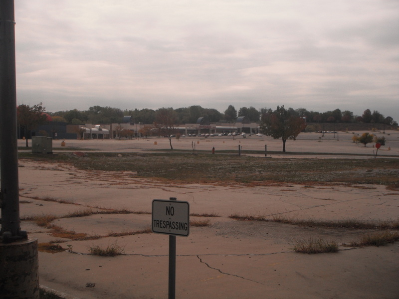
Sitting at Hillcrest Road and looking to the west, a motorist will see nothing more than a vast, crumbling parking lot with a pile of gravel as its centerpiece.  And it goes on:
And on and on:
Very little of this parking lot is accessible these days; most has been barricaded.

The east side of Hillcrest Road doesn’t look any better.  Some might argue that it looks worse: it includes several independently operated strip malls tethered to big-box anchors, the vast majority of which are completely vacant.
Because the buildings are still standing but have suffered from a decade of neglect, they enhance the feeling of desolation far more than the vacant parking lot where Bannister Mall once stood.
Sometimes its possible to guess the previous tenant, based on colors or architectural details associated with a certain brand.  On the slightly zoomed-in photo below, my suspicion is that the store on the left, with the big red block as an entrance, used to be a Circuit City, which of course is now completely out of business.
Incidentally, the strip mall above is in better condition than most: as of the fall of 2012, it still had at least a few tenants:
Yes, it’s that old mainstay of struggling suburbia: the notorious Burlington Coat Factory, known in many circles as “the Grim Reaper of the retail world”.   I’ve written about it on this blog before, because it’s no different in Indianapolis or Cleveland or Philadelphia or Anchorage.  Clearly the corporate strategy is to locate in depressed big-box settings, which not only keeps its expenses down but improves the stores’ accessibility to its target low- and moderate-income demographics.  Burlington Coat Factory’s approach, however, has become so unsubtle that many people immediately associate the retailer with poor parts of town.  And since BCFs tend to survive long after other middle-income retail tenants have fled the scene, situations like the Bannister corridor in Kansas City only amplify the retailer’s potentially undeserved seedy reputation.  In this particular strip mall, the only other surviving tenant was an urban-oriented apparel store whose name was unknown to me.  The rest look like this:
According to the buzz online, the storefront next to the Burlington Coat Factory used to be a Wal-Mart, but it, too, flew the coop.  I’m not sure I believe this though; nothing I could see suggested the appearance of a former Wal-Mart, though the magnitude of this shopping node would have made it a smart location for the world’s number one retailer back in its heyday.  Here’s a distant shot of the strip mall, revealing the small remaining trickle of lifeblood in the distance:


This stretch of Hillcrest Road also offers a number of interesting outparcels, presumably used as restaurants at one time.  All of them are vacant.  The first outparcel that a driver will see has a familiar look:
Tropical Palms Restaurant may be closed, but the distinctive appearance of the building hints at its likely origins.  I could be wrong, but the striped awnings, the brickwork, and the trim all evoke an aged prototype of Applebee’s. (Inter alia, the awnings have a greater variety of stripes these days.)  It would make sense if this were an Applebee’s, since the restaurant megachain has its headquarters in KCMO.  Other shuttered restaurants sit nearby.

Again, many of these outparcel structures have distinct enough design features that a good pair of eyes (or anyone familiar with the Kansas City chain restaurant scene in 1992) could discern what used to inhabit them.
Apparently Luby’s Cafeteria once had locations in the Kansas City metro; these days the small chain survives almost exclusively in Texas.
Only one of the outparcels suggested it hosted something other than a restaurant:

Continuing north along Hillcrest Road as it approaches its terminus at East 87th Street, the abandonment is most pronounced.
With an unusual combination of bold colors and a formidable size, I cannot guess what tenants this big-box contained two decades ago, though a Google Streetview suggests, from a handful of cars in the parking lot, that was still marginally occupied as recently as September of 2011.  Across the street, an isolated big box shows traces of life, evidenced by the few cars parked at the far-right margin of the photo.
But, upon making a u-turn and reverting southward along Hillcrest, another strip mall on the west side of the street (the same side as the former Bannister Mall) is so derelict that all entrances have been blocked off.
I wouldn’t have dreamed of driving through regardless; the potholes would have been murder on the tires.  But I could still pull into the little alcove between the access road and the barricades so I could snap a few more photos.
The labelscars left by old tenants revealed the following: a nail salon, a tax preparer, a beauty parlor, a dry cleaner—in other words, the shopping center was only attracting minor, lower-tier tenants before it closed completely, just as was the case with Bannister Mall.  What’s particularly interesting to me is that, even though the privately-owned shopping plazas were uniformly derelict, the right-of-way itself—city managed Hillcrest Road—was in surprisingly good condition, and it was even undergoing some minor repairs while I was there that day.
Notice that the road is four-lane, with a median and copious turn lanes.  When the Bannister Mall flourished, this was no doubt a bustling corridor, but these days a person could crab-walk down the middle of the street with little threat of contact with car.  The only reason Hillcrest Road was built for such an LOS was the retail it served.

After continuing southward to return to the Bannister Mall site where Hillcrest intersects with Bannister Road, the sign for one other prominent retail pokes up above the slope.
Yes, a Kmart still survives, even as its competitor, Wal-Mart, fled the scene of the crime years ago.  Such is the fate of this once mighty budget department store.  Kmart has persistently failed to compete with Wal-Mart or Target, and it has only survived by clinging to Wal-Mart’s discarded suburban fragments.  In 2010, I blogged about how Kmart has resigned itself to locations that neither Target nor Wal-Mart will touch; the dying old chain can only compete because there’s nothing else around for miles.  Such is the case with Bannister Mall, and it doesn’t get much better at other smaller retail nodes in southeast Kansas City: about a mile east on Bannister Road, the Robandee Shopping Center is in nearly as sorry of a state.  This portion of the Kansas City limits declined at the same time as the now-prosperous suburb of Lee’s Summit (pop. 91,000 in 2010) skyrocketed.

Yes, Bannister Mall and its ensuing suburban blight is a byproduct of white flight.  Similar life cycles first emerged all over America in the 1950s, leaving impoverished urban inner cities in their wake.  Meanwhile, the earliest suburbs, preferred destinations of the emergent post-war white middle class, are now routinely showing their age.  All too often, their demographic profile is similar to the inner cities, but with a determinedly auto-oriented suburban appearance.  For those of my readers in Indianapolis, the 1990s trajectory at Bannister Mall eerily parallels what happened in the Eagledale neighborhood and Lafayette Square Mall over the last twenty years.  (I blogged about Lafayette Square in the same article where I explored Burlington Coat Factory, which—surprise!—is a tenant at the aforementioned dying Indianapolis mall.) In both Indy and KCMO, these auto-oriented districts fell within the city limits and fed into their already declining public school districts.  The housing in Indianapolis’ Eagledale is almost identical to that in the Bannister Road corridor of Kansas City.

But the economic forecast of Lafayette Square and Eagledale still seems nowhere as bleak as that of Bannister in Kansas City, at least to me.  Not only is Lafayette Square Mall still hanging on (though hardly flourishing, with about 50% vacancy), the sundry strip malls and big-boxes around it are surviving as well.  None of them are thriving, and national chains have largely fled Eagledale to the suburb of Avon, just as they migrated to Lee’s Summit outside Kansas City.  But the Lafayette Square district has hosted a huge variety of immigrant entrepreneurs, and now the area is known for its ethnic supermarkets, taquerias, hookah cafes, and restaurants catering to a few dozen different non-American cuisines.  The city is teaming with the Department of Public Works to re-brand the area as an international marketplace.  In addition, an emergent artist community has taken advantage of the cheap rents and leased an old Firestone outparcel near Lafayette Square, turning it into the Service Center for Contemporary Culture and Community: a performing arts space, library, community garden, and art gallery, taking advantage of the area’s eclectic demographic mix.  Eagledale in Indianapolis may no longer be a middle class neighborhood, but it doesn’t look like the aftermath of a nuclear holocaust.

The Bannister Mall site has stumped developers and city officials over the years, since southeast Kansas City in general seems to be evading any sort of organic re-invention.  I suspect that Kansas City, generally a prosperous metro area, has its own immigrant-influenced equivalent to Lafayette Square/Eagledale in Indianapolis, but the old Bannister Mall certainly isn’t it.  This variant on socioeconomic blight poses a wicked challenge.  I’m not holding my breath for the hipsters or the gays to colonize it, the way they are in some of Kansas City’s formerly dying old walkable neighborhoods closer to the central city.  And the yuppies won’t come in later to gentrify it either.  The blight that afflicts Bannister and Hillcrest Roads has yet to reveal a treatment.

Tuesday, November 27, 2012

Surrendering to the flow.

My latest post is up at Urban Indy.  It focuses on a new proposal for revitalizing the main street of Greenwood, Indiana, a suburb of Indianapolis.  The town's central business districts is essentially four blocks that project from an intersection--except that 1/4 of the original building stock was demolished decades ago for a parking lot.  Now the plan is to fill in that parking lot with a dense, mixed-use building that hopes to shift the city's sleepy retail center into a regional destination.


 Most aspects of the revitalization plan seem laudable.  However, I took minor issue with the plan to change the flow of vehicles along this very narrow main street.  Understandably, city leadership wants the area to be more pedestrian friendly, ideally through wider sidewalks and an inviting streetscape.  However, they also hope to change the directional possibilities of some of the streets.  They want to go from the aerial below, where all streets are two-way...


To this:


The latter will take Greenwood's Main Street and make it one way through the entirety of the old commercial district.  I don't think this is likely to help the retail fortunes of the main street, especially since communities large and small are reverting their urban one-way streets back to two-way.  Through Urban Indy, a fellow contributing writer and I devised several questions we think are critical as the City of Greenwood establishes its priorities in developing a good design strategy for what could become a picturesque, desirable downtown.  We have already spoken with a key member of the Greenwood Economic Development Commission, and he encouraged us to write this article.  Hopefully the publication will add to the fruitful dialogue as key stakeholders devise a design solution to this corridor with serious constraints.  And, as always, I welcome further questions from readers here at American Dirt.


Wednesday, November 21, 2012

Streetscapes get a much-unneeded boost.


In recent years, communities large and small have sought new approaches to restore the vitality of their historic business districts.  By this point, virtually everyone can think of a municipality with an old downtown that really does feel like it’s the center of it all: fully occupied buildings, people milling about.  The success stories exist.  But that doesn’t mean it’s getting any easier.  By no means are they abundant, and, after decades of disinvestment, I suspect we’ve lowered our standards for what constitutes a flourishing city center.  A town of 10,000 with five operational restaurants in the old downtown buildings is cause for celebration, and rightfully so.  Twenty years ago, such conditions might have seemed unattainable.

But even a 50% occupancy rate for the old business district has eluded many other cities and towns.  Over the decades, factors contributing to downtown disinvestment have become increasingly complicated and the design solutions ever more nuanced.  I’ve written before about the negative influence that automobile dependency had on small towns, but it clearly isn’t the only phenomenon that contributed to their virtual demise.  The basic cadences of consumerism have changed in the last half-century; the greater dependence on wholesale merchandising and standardization cataclysmically altered the requisite size and internal configuration of stores.  Now much of our shopping takes place at big boxes that front a vast parking lot.  The growing dominance of online shopping is likely to foment another retail revolution, and, if the Internet eventually dictates how the majority of us shop, it remains to be seen how our built environment will adapt—if it is even capable.  Meanwhile, as more small towns seek to repurpose their old commercial centers so they become a viable destination once more, many civic leaders are finding that a well-scrubbed streetscape and a good PR campaign just won’t cut it.

Thanks to persistent technological innovations and unforeseen sociopolitical considerations, the very dimensions that governed good urban design have irrevocably changed.  The most obvious manifestation of this cultural seism is the availability of parking: since the majority of people now depend on private vehicles to get around, will these old downtowns originally designed for pedestrians ever be able to accommodate cars with the space they need?  Is demolition of some of the old downtown buildings the only real solution to open up more available space?  And, if so, won’t the absence of those demolished buildings create fewer opportunities for the commerce necessary to convince people to visit the downtown in the first place?  Countless municipalities of all sizes have squared off with this conundrum, finding answers with varying degrees of success. 

A town like Bastrop, Louisiana in the photo below, benefits at the very least from having a clearly articulated center.


It is the seat of government for Morehouse Parish, evidenced by courthouse resting in the dead center of town.  And like many towns of its size (approximately 12,000 inhabitants), older commercial buildings wrap around all sides of the central courthouse square.

In a more heavily urbanized part of the country such as the Lower Midwest, this configuration is the standard for county (or parish) seats.  In Louisiana, it is comparatively rare, with three primary explanations.  First of all, the more rural parts of the state have such sparse populations that the seat of government may be less than 2,000 people—not large enough to justify a downtown with a full central square and four blocks of perimeter commercial buildings.  Some parish seats are little more than a cluster of buildings stretching on both sides of the street near the rail depot, crowned by a humble administrative center.  Secondly, Louisiana parishes do not always centralize the government in a single municipality: sometimes the judiciary sits in one community and the governing arm (usually called a “police jury” in Louisiana, just as it is in Morehouse Parish) sits in another.  The scattering of government buildings across multiple locations in a parish further dilutes the likelihood of businesses and administrative services aggregating in a well-developed downtown.  Lastly, Louisiana is among the less incorporated states in the country.  A higher proportion of governance takes place at the parish level than even most southern states, because the state has relatively few incorporated municipalities.  Compared to neighboring Mississippi, where even the most rural counties have at least one incorporated town (and usually two or three, if not many more), several parishes have no incorporated areas, including the parish seat(s).  A paucity of municipalities translates to fewer city halls or other civic buildings that typically occupy a downtown.  In having most of the characteristics of a parish/county seat, Bastrop is unusual by Louisiana standards, particularly the more rural northern half of the state.

Downtown Bastrop is therefore more urbanized than many other towns.  It has a solid architectural fabric to work with—maybe not as many multi-story buildings as you’d see in a county seat in Yankee country, but the structures still front the street and collectively form a downtown that is suitable for pedestrians and easy to navigate.

Nonetheless, Bastrop faces formidable challenges in revitalizing its downtown, because the prevailing economic tide in the region isn’t just encouraging migration away from the old town center—people are leaving the region altogether.   The city’s biggest recent blow took place in 2008, when Memphis-based International Paper Company announced the closing of its Bastrop mill, which forced over 500 workers out of jobs and no doubt sent many ancillary businesses into retreat.  Meanwhile, a number of poultry plants in surrounding parishes closed down in the ensuing months.  State subsidies managed to staunch some of the hemorrhaging jobs by incentivizing one poultry company to purchase the shuttered factory of another, but the census reports cannot conceal the fact that both Bastrop and its environs are struggling: Morehouse Parish has been losing people since 1980, and it shed 9.8% of its population in the last decade, a new high.  Neighboring parishes aren’t faring much better: East Carroll Parish to the east and Richland Parish to the southeast have also lost population from 2000 to 2010.

Despite these hurdles, downtown Bastrop shows evidence of streetscape enhancement projects that typically intend to add a new sheen to downtowns.  The west side of the courthouse square particularly caught my attention:
It features a generously wide sidewalk, with a protective wrought-iron gate stabilized by brickwork separating the pedestrian path from the street.  Healthy street trees at equal intervals provide an additional buffer.  But there’s something strange about how these are arranged, which the above photo deliberately obscures somewhat.  The next two photos, however, do not.
That’s right.  The sidewalk is at an entirely different grade than the street level, with a difference of close to two feet.  Those gaps in the wrought-iron gate?  Access points with a few stairs.
I find this bizarre, because the sidewalk is merely meeting the elevation of the entrances to all the buildings on this block of downtown.  For some reason, the doorways to the commercial buildings on this block of downtown Bastrop are at a different grade from the street—different enough to require stairs for access.

Bastrop, like most of Louisiana, is not exactly a city of rugged topography.  And none of the other blocks that front the courthouse square have such a grade change.  Look at the northeast corner of the square, for example.
Nothing unusual about the curb separating the street from the sidewalk.  (This photo also gives me opportunity to promote two older blog posts: the 1950s-era Googie façade to this old building recalls an essay from not so long ago on Thibodaux, Louisiana, while the probable Jewish last name evokes an older, extensive exploration of Jewish settlements in the rural South.)

So why are the sidewalk and the storefronts elevated on the western block?  In terms of the buildings, I’ve exhausted both my gray matter as well as Hercule Poirot’s and can’t really come up with anything; perhaps some dusty city archives would explain the rationale for this, but it has lost me completely.  As for the sidewalk, it obviously has to meet the buildings to provide access, but this streetscape improvement seems a bit too au courant to date from the same time period of the buildings.  At the same time, it neglects one crucial consideration visible in most “improved” downtowns: access for persons with disabilities.  Those little stairs leading from the on-street parking to the sidewalk aren’t the least bit compliant with the Americans with Disabilities Act.  Fortunately, the corner crosswalk seems to be compensating for this major oversight:

But this must be a recent modification; the cement doesn’t even look fully dry.  At least a ramp allows people in wheelchairs access to the handful of occupied storefronts along this block, but the lack of any further ramps means people in wheelchairs are trapped along a sidewalk/corridor, at least until the block ends at the next corner.

Is this observation of mine a niggling one?  Absolutely.  I’m not going to begin to advocate that Bastrop Public Works should perform invasive surgery on this attractive sidewalk at this point.  The engineers have made corrections to mistakes from the past, and the sidewalk is broadly though not optimally accessible.  But the interventions demonstrate how relatively fixed, immobile infrastructure cannot simply mould itself to shifting cultural values.  In 1920, when downtown Bastrop no doubt was the retail/commercial epicenter of Morehouse Parish, a sidewalk with a huge grade change posed a burden to practically no one; you would deal with it simply by stepping up.  By today’s standards, such an approach excludes a significant enough portion of the disabled population that it became codified as ADA in 1990.  Now such a design is unacceptable, and even ADA has undergone modest modifications since its enactment to accommodate other constituents previously ignored.

I have no doubt that somewhere in America, right at this moment, a construction team is building a publicly-supported project that a future generation will recognize as a flawed design.  It might even become unlawful.  We aren’t prescient, but we should at least remain aware that we will never fully reach our goal, because the process of achieving them will only elicit further hurdles.  And we must temper our nostalgia for old-timey downtowns with a recognition we really cannot go back; in many regards, we wouldn’t want to.  All the words we apply—“revitalize”, “restore”, “revert”, “return”, “reinvent”—use the Latin prefix re-, which can mean either “again” or “backwards”.  The eye must remain on the future, not only for the sake of our evolving downtowns, but that is where a city like Bastrop, still sore from recent job loss, can throw the rest of its skin in the game.

Friday, November 16, 2012

No need to move mountains; just plant the right kind of trees.

Across the country—but particularly in the heavily industrialized Northeast and Midwest—smaller cities have confronted the grim realities of the unflattering “Rust Belt” moniker, and all of its associated characteristics, with varying degrees of success.  With an aging work force, difficulty in retaining college graduates, and a frequently decaying building stock, the challenges they face are formidable.  Cites from between 30,000 and 80,000 inhabitants typically boomed due to the exponential growth of a single industry, and, in many cases, the bulwark of that industry left the municipality nearly a half century ago, for a location (possibly international) where the cost of doing business is much cheaper.  Essentially, everything the smaller Rust Belt cities had to offer is completely tradable in a globalized market; the resources that provided the town’s life blood are either depleted or are simply to expensive to cultivate further.

Reinvention is the only condition likely to save many of these cities from persistent economic contraction, but, with an overabundance of retirees and older workers, these towns lack the collective civic will that could be expected in larger communities with more diversified economies.  An absence of young people intensifies (and, to a certain extent, justifies) the low level of civic investment in one’s own community; after all, if a resident is six months from retirement, how likely is it that he or she would support public investments intended to improve quality of life for twenty or thirty years into the future?  For that matter, how likely will a population of retirees remain engaged to encourage or challenge major private sector investments as well?

By no means am I intending to denigrate needs and ambitions of the senior population; I’m merely observing that a stagnant Rust Belt city with this demographic profile will demonstrate vastly different priorities from a city rife with young families.  While every Rust Belt city large and small must avoid obsolescence that results from the spoils of globalization, the smaller cities—which have tended to be dominated in the past by a single thriving industry—are less likely to claim alternative sectors and labor pools if their primary manufacturing lifeblood fails.  A dying city of 80,000 may not exert the same impact within a region (particularly in the densely populated Midwest and Northeast) that a city of 500,000 would, but it is far more of black eye for the state than a town of 2,000 that has lost its raison d'être.  This conclusion is obvious.  Many of these small cities must reordering of their economies comprehensively; while the state, the county, or private foundations may offer some outside help, the constituents of these cities themselves are typically the best equipped to understand how their city should evolve.  Unfortunately, many of these communities aren’t yet even aware of the need for this reinvention, let alone which avenue to pursue in order to achieve it.

It is with no small amount of reassurance that I can assert that Kokomo, Indiana is not one of these latter cities.
No Rust Belt complacency on display here in the City of Firsts.  Though a recently as 2008 it was on Forbes’ list of America’s Fastest Dying Towns, a recent visit shows much more evidence than I’ve seen of some comparably sized cities in the region that the civic culture is neither resting on its laurels nor wringing its hands about how much better things used to be.  In fact, one of the Indianapolis Star’s leading editorialists, Erika Smith, recently visited the city, and, after receiving a tour from the Mayor, was pleasantly surprised by how proactive it has been in implementing precisely the type of quality-of-life initiatives largely perceived as necessary to help a historically blue-collar city stave off a brain drain or descend into irrelevancy.

I, too, recently received the Kokomo tour, followed by a meeting with Mayor Greg Goodnight, and I can also recognize some of the city’s most impressive achievements at shaking off the post-industrial malaise that saddled the city with double-digit unemployment rates as recently as a few years ago.  Since then, the city has introduced a trolley system at no charge to users; prior to this initiative, the city had had no mass transit for decades.  The Mayor pushed successfully to annex 11 square miles in the town’s periphery, therefore elevating the population by about 10,000 people.  The Mayor’s team worked to convert all one-way streets in Kokomo’s downtown to two-ways, recognizing that accommodating high-speed automobile traffic in a pedestrian-oriented environment only detracts from the appeal.  The team has restriped several miles of urban streets to incorporate bike lanes, and it has converted a segment of an abandoned rail line into a rail-with-trail path, branding it by linking it to the city’s industrial heritage.  They have deflected graffiti from several bridges and buildings through an expansive and growing mural project.  They have upgraded the riverfront park with an amphitheatre and recreational path. They have introduced several sculptural installations, the most prominent of which is the KokoMantis, a giant praying mantis made entirely of repurposed metal and funded privately.  And my personal favorite: with the support of the City, the school superintendent has integrated a prestigious International Baccalaureate (IB) program to the public school system, including an international exchange program for young men from several foreign countries (a girls’ program should arrive in the next year or two) who live in a recently restored historic structure in Kokomo’s walkable downtown, attending demanding courses that bolster their chances of admittance in a coveted American university.  Most impressively, the City of Kokomo has achieved all of this without incurring any public debt in the past year.

Obviously the individuals offering me this tour are going to make sure their Cinderella is fully dressed for the ball, and I recognize that not a small amount of the securing of certain infrastructural projects and transportation enhancement grants requires a political savvy that the current civic leadership has in abundance.  And I don’t want to rehash Ms. Smith’s article, which more than effectively chronicles this approach at a macro level.  In addition, Erika Smith recognizes, as do I, that very few of these initiatives (the IB foreign exchange program notwithstanding) are really particularly earth-shattering.  But when most other similarly sized cities in the Midwest seem to be engaged in a race to the bottom, luring new industry through generous tax breaks (often initiated at the state level), Kokomo seems to recognize that a town lacking any amenities outside of low cost of living has to compete with dozens of other cities in Ohio and Michigan and Pennsylvania, and elsewhere in Indiana, that offer the exact same brand.  Whether this investment yields a long-term return remains to be seen, but it certainly demonstrates the right gestures necessary to instill civic stewardship in a place whose decades of job loss have seriously scratched its mirror of self-examination.

What ultimately struck me about Kokomo—which Erika Smith only touched upon—was the level of design sophistication evident in some of these civic projects.  I need only focus on a single location in the city, in which two particularly laudatory techniques are on display.  At the intersection of Markland Avenue and Main Street, just south of downtown, the Industrial Heritage Trail begins its journey southward.  Here’s a view as the trail terminates at its junction with those two streets, looking northwestward:
Here is a view in the other direction:

Continuing a bit further in this direction, one encounters this painted wall:
And, pivoting slightly to the left, another mural that is still in progress:

This photo series identifies two amenities that stand out for the astute decision-making that apparently took place during the implementation.  The Industrial Heritage Trail clearly operates a railway corridor, but it is not a rail-trail.  Unlike the more common rail-trail conversion, this Kokomo trail did not incorporate the removal of the original rail infrastructure.  The Rails to Trails Conservancy would label this approach a rail-with-trail, indicating that the trail shares the railway easement, typically separated by fencing.  Rail-trails such as the Monon Trail in metro Indianapolis are still the more common practice.  However, a growing number of communities are embracing rail-with-trails, not only because they obviate the need for costly removal of rails, ties, and ballast, but they reserve the rail infrastructure for the possibility that a railroad company may reactivate the line in the future.  If the sponsors of Kokomo’s Industrial Heritage Trail had removed the infrastructure, the possibility of ever reintroducing rail along the corridor would be virtually nil.  As it stands, the only conceivable disadvantage to rail-with-trails is that, in the event a rail company reintroduces train service, its close proximity to the path may prove hazardous to bicyclists or pedestrians.  Otherwise, the decision to retain the railway not only helped to diversify options, it most likely saved a considerable amount of money.

The other smart decision was the site selection for those murals.  The ones featured in the photos above are part of a growing mural campaign that the City of Kokomo introduced, and every one that I recall shows real foresight in the locational decisions.  What makes them so good?  The murals in the photos above front a public right-of-way, minimizing if not completely precluding the chance that later development will conceal them.  I blogged a few years ago about an excellent mural in Indianapolis that showed wonderful care and craft in the entire implementation process…except where the conceivers chose to locate it.  Not only did they paint on a cheap, cinder-block building that will likely tumble down if market pressures encourage new development in the neighborhood, but the mural also faces a vacant lot which is large enough to host a new structure that would block it completely, no doubt frustrating the community and pitting them against a developer.

Compare this to Kokomo’s murals.  Here’s one a little further south on the Industrial Heritage Trail:
Again, it fronts the trail itself—not a chance that a developer will try to block it.  And here’s another along a bridge underpass for the recently completed trail along the Wildcat Creek:
The original intention of the mural was to repel vandals at spot that previously suffered from it frequently; this approach has proven successful in locations across the country.  But it also sits in a park along a new greenway, so it should remain in perpetuity.  Granted, Indianapolis has plenty of murals along retaining walls and buildings that front the aforementioned Monon Trail.  Those, too, should survive far into the future.  But in recent years, the City of Indianapolis has encouraged countless murals on the side walls of commercial buildings—sites where a blank wall faces a parking lot, where a building once stood.  While these bare walls often scream for some ornamentation to help distract from what used to be there (another adjoining building), in many instances the parking lots will likely fall under increasing development pressure in upcoming years.  Will the locals thwart development in order to save the mural?  This remains to be seen, and I don’t want to base too much of an analysis on speculation.  But it’s hard to deny that these public art investments seem less astute than the once I witnessed in Kokomo.

One could argue that Kokomo is merely taking advantage of the fact that it is jumping into the game relatively late; it benefits by learning from the mistakes of others.  But decisions that stand the test of time also contribute their fair share to foster civic goodwill.  Taxpayers are rarely too forgiving of poorly conceived projects, and several successive blunders, no matter how small they may be, demonstrate poor accountability.  Only time will determine the return on investment, but Kokomo certainly has a leg up on many of its competing small cities,  My suspicion is, if these projects stimulate the discussion and enthusiasm for proactive leadership that they suggest (Mayor Goodnight was re-elected last year by a landslide), the citizens of Kokomo are only beginning to stoke the fire.