
Anyone from Indianapolis with more than a passing interest in this blog no doubt knows that the city had once earned the title of “Interurban Capital of the World”. Indiana boasted over 2,400 miles of tracks, 12 of which converged at the Traction Terminal building at the state’s capital. With the exception of Evansville, all major cities in Indiana were connected through the interurban system, and the tracks helped foster the growth of some of the earliest suburbs. [Far greater detail on the interurban’s history in the city is available in the section “Transportation” by Ralph D. Gray, in The Encyclopedia of Indianapolis, Eds. Bodenhammer and Barrows, 1994]
Because so many of the suburban growth patterns of the city disproportionally favored the north side of downtown, the College Avenue interurban route—which would begin on the eastern edge of downtown and head northward into the rural purlieus—was undoubtedly among the most prominent. At its peak in the 1910s, the College Avenue route offered the primary means of transport for wealthy citizens in what were then outlying suburbs such as Mapleton, Watson-McCord, Meridian Kessler, Forest Hills, and Broad Ripple. Any heavy construction work on College Avenue most likely reveals the old embedded rails buried under layers of asphalt.
The interurban stops helped to spawn architecture that served the passengers at the various stops where they would disembark. Even after seven decades since the interurban’s demise, many vestiges of the interurban-derived architecture survive, with structures that have housed retail, offices, and even some residences. The College Avenue corridor vaguely resembles the suburban communities connected, like beads on a string, through the US 30/Lancaster Avenue corridor that comprise Philadelphia’s famed suburban “Main Line,” though at a different scale. (The biggest difference, of course, is that the Main Line in Philadelphia survives as a commuter rail, and the stops along this track aren’t mere commercial nodes but are actual suburbs, such as Narberth, Haverford, Bryn Mawr, and Villanova.)
In Indianapolis, the physical condition of these nodes of activity at the old interurban stops varies greatly; in some cases, demolition has rendered the College Avenue interurban stops almost unrecognizable. Starting from the downtown area and working northward, I hope to show the intersections that most likely comprised “stations” for the College Avenue Interurban, and perhaps the viewers can fill me in on my accuracy. College Avenue runs north and south, and at each prominent intersection, I will offer four photos, starting from the northwest and working clockwise, to end at the southwest. The photo sequence will look more or less like this:

Obviously, very complicated. From this point onward, text will be limited. Hopefully the images—derived over the course of several months with multiple cameras and some inappropriate shutter speeds—will foster more than enough discussion and curiosity (and, hopefully, more artful photography than the some of the biggest duds among this series!).
400 North
The first most likely interurban stop appears where College Avenue intersects Michigan Street. The empty field on the northwest quadrant originally intended to host more condos like the ones visible in the background to the left. This area was rife with development activity before the economic downturn, and will most likely pick up again if the condo market improves.


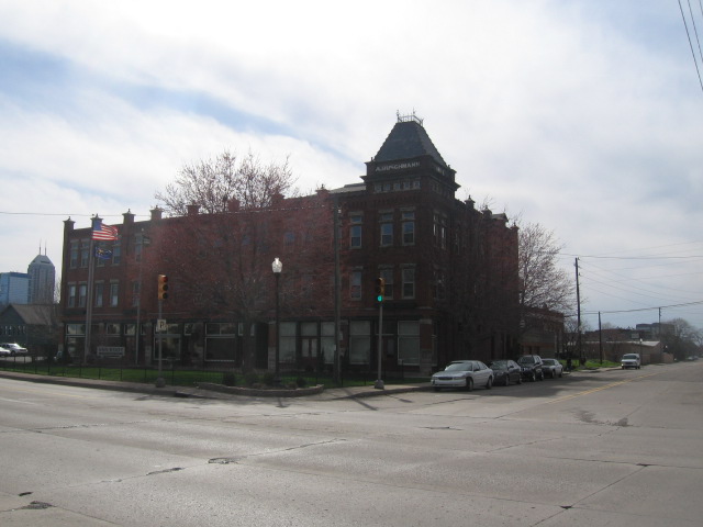
1100 North
I suspect there was at least one other interurban stop between the 400 and 1100 block, most likely at St. Clair Street (the 800 North block), but very little residual architecture survives to suggest it. The area has undergone significant redevelopment in recent years. Thus, I can only push northward to the next most likely interurban stop, at College and 11th Street. The ugly substation no doubt limits the attractiveness of redeveloping the old retail strip on the northeast quadrant.


1600 North
The next major intersection, at 16th Street, separates the largely gentrified Old Northside neighborhood from the gentrifying Herron-Morton Place. Only one of the four corners, at the southwest, shows much evidence of an old structure that likely owes its origins to an interurban stop. This partially dissected cadaver of an edifice will likely survive to enjoy a complete redevelopment in the next few years, if current trends continue. The other three corners may prove a greater challenge, but the current uses demonstrate the intersection’s legacy of depressed real estate.


1900 North
This block would not appear to be a likely streetcar stop, except for the survival of one structure at the southeast corner. 19th Street is not a prominent arterial or collector anywhere in Indianapolis, and most of the rest of the historic residential architecture of the area long ago suffered the wrecking ball, cleared for some mid-twentieth century low-rise affordable housing. But the two story building at the southeast corner endures, in generally good shape.


2200 North
There can be little question that this intersection was once a prominent interurban stop, with two structures clearly accommodating passengers who would have disembarked and continued along 22nd Street by foot. Only one of the structures, however, is good shape. But the abandoned three-story structure (southeast corner) and the northwest parcel with the squat, yellow and white convenience store could both offer redevelopment opportunities. While this part of Indianapolis seems unlikely to face revitalization in the near future, it is close to the Fall Creek Place neighborhood, the city’s single largest urban redevelopment initiative.


2400 North
A two block interval may seem too small for another interurban stop, and 24th Street is never a significant collector or arterial, but the barely used brick structure on the northeast corner still suggests that the block was once a minor retail node.


2500 North
This block may have been a more likely candidate for an interurban stop than 24th Street, since it intersects at a much busier street. But in this day and age, it is impossible to tell from the surviving structures if the trains stopped here. Vacant lots and automobile oriented substitutes comprise three of the four corners. And one corner features the first prominent gas station—perhaps the most powerful evidence how the automobile and decentralization rendered so many of these older structures obsolete. Gas stations offer a far more valuable use for these intersections than a building that responded to mass transit and foot traffic, neither of which have a powerful presence in this part of town anymore.


2700 North
This again seems too close to 25th Street to justify another interurban stop, but 25th Street is a questionable site for a historic transit stop anyway. The vacant building on the northeast corner here suggests that the intersection had some commercial viability at one time. The decorative post at the southwest corner indicates that the vacant lot may eventually host a later phase of the Fall Creek Place neighborhood.


3000 North
This busy intersection is one of the few in which the lateral street is one way: 30th Street runs eastward while its counterpart, 29th Street, flows to the west. Only the southwest corner offers much of historic interurban architecture; two other corners met their demise to more gas/service stations (one of which appears to be abandoned).


3500 North
The only interurban stop where the intersecting street is not perpendicular, Fairfield Avenue meets College Avenue while running from the southwest to the northeast. The oblique angles that it creates offer interesting redevelopment opportunities, perhaps at a later time when the already strengthening Watson-McCord neighborhood has improved a bit more. One historic building remains at the southeast corner; it has been in good shape for many years. However, a comparison with a Google Streetview from a few years ago suggests that the building at the southwest corner recently suffered demolition. Hopefully any redevelopment will have a massing that takes better advantage of the unusual parcel shape.


3800 North
College Avenue meets 38th Street, the most prominent east-west arterial in northern Indianapolis, with little fanfare. The southwest corner survives as evidence of the interurban stop here at historic Maple Road, but the buildings on the other corners have been superseded by more contemporary, auto-oriented structures (apologies for the blurry photo). The area receives a moderate amount of foot traffic, but a prominent streetscape improvement from a few years ago failed to reconcile the uncomfortable pedestrian scaled buildings that survive (most visible to the left of the Revol Wireless store in the northwest corner) with the high-speed automobile traffic on this six-lane thoroughfare. 38th Street separates Mapleton and Watson-McCord neighborhoods to the south from the generally affluent Meridian Kessler to the north.


North of 38th street, the various stops of the College Avenue interurban are typically much more preserved, as the neighborhoods have witnessed far less economic decline. Considering that I have caused some of my blog posts to short-circuit from an excess of pictures, it's probably best that I close this one for the time being. I will show these as I push northward in Part II of this montage of Indianapolis' rail transit history.


10 comments:
Fantastic collection of thoughts sir! The photos compliment the area well. One could say you are almost advocating for a return to these streets ;)
I fully agree with you about the sites south of 38th falling into disrepair that was not arrested as it was further north of 38th.
Until about 10-15 years ago, College was one-way northbound (for cars) a lot longer distance than now. Two-way traffic used to stop at Fairfield.
It's a chicken-or-egg argument in Indy whether the one-way streets killed the neighborhoods or merely coincided with their natural aging/obsolescence in the suburban growth era.
Just FYI, the Fall Creek Place redevelopment area includes both sides of College, north of 22nd to just short of the creek.
I didn't know that College used to be one way up to Fairfield. Interesting to know that there is precedent for rolling them back.
Thanks for the links, and nice post, AD.
On the SW corner of 16th, the "partially dissected cadaver of an edifice" was created when a truck rammed the building 5 years or so ago. It's amazing that the rest of the building was saved.
Also (and this is nitpicky) but Herron-Morton's eastern boundary is officially Central. The King Park website doesn't seem to specifically identify the area to the NW of College and 16th, but the NE corner is the Kennedy-King Neighborhood.
Thanks as always for all the comments. CDC Guy: I appreciate you reminding me, like Kevin, that College Avenue used to be one-way. Upon returning to Indy in 2009, it actually surprised me how little of it was one way, so an unconscious part of me must have been aware that the one-way flow comprise a much larger portion of the street in the past.
CorrND: Thanks for the correction. I was vaguely aware that the Herron-Morton historic district boundaries didn't stretch all the way to College, but I wasn't aware how strictly they apply it. Perhaps the area between Central and College was originally conceived as Herron-Morton but denied as contributing to the historic district because an insufficient amount of the old architecture survives?
I think "they" (residents and those pushing the historic district designation originally) tried to draw the Herron Morton boundaries pretty narrowly around concentrations of historically significant blocks around the Herron buildings and the old Camp Morton/State Fairgrounds.
I'd guess, as you imply, that the MLK Park area "old school" bulldozer urban renewal & superblock scheme probably influenced that choice too. Little of the historic fabric remains.
Here's an interesting map that shows the overlapping web of neighborhood associations, historic designations and other boundaries in the area around Fall Creek Place. The southern boundary of the map is right around 22nd St., but it, too, doesn't provide a specific designation for the area between Central and College. That area is included in a rather large designation called "Bruce's Place" but I'm not sure what that signifies.
What??? You mean you dont know Bruce?? ;-)
Apparently no map ever dared to label it "Dodge City"...
:)
One could say you are almost advocating for a return to these streets.
Post a Comment