When an instructor for a real estate and development class
told his students, “You can’t own a view,” he said it with the nonchalance that
suggested it should become a mantra.
What he was implying was that neither the developer nor the prospective
property owner should stake all of an investment on the quality of a view. No legal recourse exists to enjoin a
landowner from building in a fashion that inhibits or weakens another
individual’s perspective from the window or front door, regardless of how much
that waterfront, mountain range or skyline gratifies the eyes. Lines of sight are nebulous enough that
private ownership of them is difficult to protect or enforce: if everyone was
entitled to his or her view, nothing could ever get built. Any collective attempt to protect a
view loses its punch, because the magnificence or importance of the objects
beheld is highly subjective. Thus,
the retention of the prized object itself will usually earn more legal credence
than access to the “viewshed”, a contemporary buzzword appearing in Wikipedia (but not most dictionaries). While it is possible that Landowner A
could seek an injunction against Landowner B’s development permit under
environmental, historic preservation, or public health considerations, in most
circumstances, view deprivation does not evoke a judge’s sympathy.
Nonetheless, the private market continues to demonstrate how
greatly people value a fantastic view in aggregate, regardless of the
likelihood that something else in the future will impede it. Waterfront high-rise residential
buildings still command high prices, not only because of the proximity of the
building’s front door to the water, but also because of the terrific views at
the pricier higher levels. The
fenestration of many high-rise buildings exclusively orients itself toward the
side with the great views, since windows on the other side are not worth a
fraction. Conversely, the market
also tends to shun properties with particularly poor or unappealing views. The price that consumers attach toward
great views makes this fairly recent multifamily development in downtown
Indianapolis, known as the Maxwell, that much more of an oddity.

The developer Kosene & Kosene completed this structure a
few years ago, with the intention that it would function as condominiums, but
it entered the market at the bursting point of the real estate bubble, when
downtown condos sat empty and unsold.
Thus, the developers repositioned the building as luxury apartments, and
the smaller units (studios and one-bedrooms) sold quite briskly. The numerous chic Art Deco references
probably aligned with young professionals’ tastes, and the location just south
of the heart of the Lockerbie Square neighborhood was ideal. In short, the Maxwell could command
high prices as rentals. And, as
Indianapolis midrises go, it’s big, at 105 units occupying one quarter of a
city block: with the exception of an interior courtyard, it covers nearly the
entirety of its parcel, indicated through this side view:

The above photo also reveals that the designers devoted the
entire frontage along Ohio Street to retail and saved the back for slyly
concealed resident parking spaces.
Such a move placates urban advocates who have criticized other midrise
developments in Indy for neglecting retail altogether; the Regional CenterDesign Guidelines of Indianapolis also stress the need for first-floor retail in residential
developments. However, the
absorption of this retail space so far has been problematic. As this December 2011 photo below
indicates, most of it remains vacant, almost three years after completion:

Only the easternmost corner has a tenant—a total of about
25% of the Maxwell’s retail GLA.


To its credit, the Maxwell has successfully secured a highly
successful temporary tenant for that large space in the past: the Indy Winter
Farmers Market. But it has never
found a permanent occupant. Why is
the retail here so hard to lease, when it has a reasonably high-density
concentration of well-heeled residents right above it? Well, the building doesn’t sit at a
prominent intersection: the north-south street at the corner, Park Avenue, is
never more than a local road, with very low traffic volume. This building sits right at the
southern edge of a neighborhood, with an as-of-yet largely undeveloped ocean of
parking directly south of Market Street, which weakens its opportunities for
pedestrian activity. Very few
other buildings in this portion of Ohio Street support retail, so the Maxwell
is largely alone in that regard. But
the biggest Achilles heel is what sits directly across the street from this
upmarket residential building:

An electrical substation—not most people’s idea of the
Eiffel Tower, the Chrysler Building, Lake Tahoe, or even the Hollywood(land)
sign. Such goliaths are
commonplace in downtowns, since they provide a centralized source for the
“stepping down” of voltage from the original (coal) power plants to a more
suitable level that serves neighboring communities. My estimate is that the average buyer would think this is
ugly. Who would want to view this
from a front window? Accompanying
its ungainly appearance is the toxic perception—whether real or imagined—that
they are noisy or potentially dangerous.
Given these considerations, what prospective business owner would choose
this as a location for a restaurant or boutique when so many better
alternatives exist? While it’s
hard to tell from the photographs, the one tenant (Civil Engineering
Consultants, still there at the time of this blog post) has Venetian blinds
which it often keeps partially drawn.
Despite the positive buzz the Maxwell generated when it was completed, I
have my doubts that even during the best of economic times it would have worked
as a condominium, thanks in large part to that view. Renters are going to be less particular, but clearly an
owner will just see this as one facet of the overall investment, and not a
positive one.
Whether unconscious or not, it would seem that the folks at
Kosene & Kosene who built the Maxwell took the aforementioned maxim “you
can’t own a view” and inverted it to their advantage. The location, just outside of the edge of one of the city’s
elite urban neighborhoods, endowed it with an apparent strong potential to
market as luxury or at least high-end housing. But the appearance of the electrical substation across the
street deflated the assessed value of the property and no doubt helps to
explain why no other developer had stepped up to the plate in area that had
been experiencing a multifamily housing boom for years. Maybe the biggest element of risk
was the attempt to build condos here; like most urban condominium projects, the
developers have usually conceived of the viability of their structures as
apartments as well—part of a safeguard against a soft ownership market. And the Maxwell could continue to enjoy
viability as a high-end apartment complex for years to come. But my guess is that if it someone
hoped to make it into a condominium complex, he or she would have to do
something about that substation.
Three options come to mind. The first, though widely implemented in Europe, is
relatively rare in the US: to bury the substation. Anaheim (California) Public Utilities received a fair amount
of attention when it recently built a new substation under the 2.5-acre Roosevelt Park, with maintenance access points built inconspicuously into a
hillside. The inception of this
new substation was a response to steady population growth—a contrast from the already
existing one across the street from the Maxwell in Indianapolis. Burying a pre-existing substation would
amount to a huge expense for merely aesthetic goals, and since there is no
financial incentive for Indianapolis Power and Light Company (better known as
IPALCO, lesser known as a subsidiary of Virginia-based AES Corporation) to do
so, the most likely resolution would be funding through a city subsidy. Since a subsidy to improve aesthetics
of a small, obscure substation is likely to prove hugely politically unpopular,
this solution is probably already dead in the water.
The second of the three options would be to conceal it
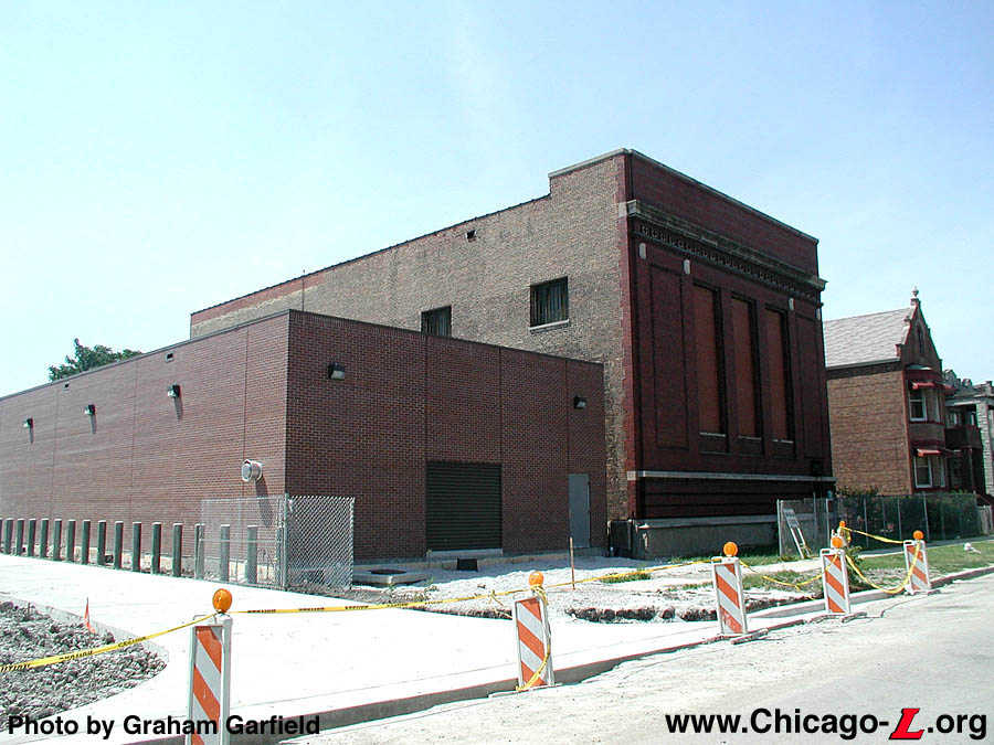
through a sheath, as has been attempted many times, with mixed success. All too often, the resultant structure
is an imposing, windowless titan of brick or concrete, surrounded by a
chain-link fence—an marginal improvement over the exposed utility that is so
architecturally uninspiring that online searches offer few examples (this one in Chicago is an exception). But it doesn’t
have to be this way: European cities have long sheathed their substations
within chic façades, and, according to a 2008 New York Times article, Consolidated Edison found a way to hide
a recent South Bronx substation within a multi-story sheath with “windows”,
which proved so effective that passers-by asked when the condos would start
going up for sale. Cheaper than
burying an existing substation, building a sheath would seem to be the best
option if the owners of the Maxwell ever hope for a viable conversion of their
apartment building back to condominiums at some point in the future.
The third and final option is a flight of fancy, but I have
to mention it because it echoes an endeavor I proposed in this blog a few years ago, in order to mitigate the relentless prominence of utility
cables across older New Orleans neighborhoods. The following 2009 NewYork Times article references how electric substations “lack the perverse
elegance of utility poles or transmission towers”, in order to bolster an
argument for following Anaheim’s example by burying one under a city park. Perverse elegance was exactly what I
had in mind when I thought that New Orleanians should turn their tangle of
poles and electric wires into a pop culture meme, much the way they already had
with water meter manhole covers. And
trendy loft apartments have found beauty in exposed ventilation ducts for at
least a decade or two. Who’s to
say substations are objectively ugly?
Surely a gifted spin-artist could turn the spiny monster across from the
Maxwell into a suavely strummed chord from a twelve-string guitar, or an
irregularly metered stanza from an urban poem. Since it’s probably a bit dangerous to host a café, art
installation, or a miniature skate park within the chain link fence (or even
along the sidewalk adjacent to it), one can at least probe the substation’s
intrinsically curious qualities, like the one in the photos below:


What’s going on with those railroad tracks that terminate
abruptly at the chain link fence?
Do they serve a purpose, or did they have a function in the past? Could they have linked to an old
interurban line? If this parcel of
land offered even a trace of a sordid history, it could re-integrate itself to
the public consciousness in a chic fashion that just might even allow it to
transcend its perceived assault on the senses. Obviously this option is a stretch, but it would undoubtedly
prove cheaper than blotting it from the landscape, and it would earn a greater
integrity because of the creative verve that generated it. (Whether it would last a full decade as
“hipster infrastructure” is another concern altogether.)
The act of brainstorming these potential solutions for the
Maxwell Apartments in Indianapolis only serves to weaken the “you can’t own a
view” assertion—even if it’s true from a legal standpoint, the psychological
ownership of views are immutable.
Quite simply, people will think they own a right to this view if they
own property that forces them to look at it. They will manifest their sense of ownership in either
planning and development hearings, or simply through deflated prices and
reduced market demand. Only steady
persuasion of the reality of the real estate market stands any chance of
convincing them otherwise. In this
downtown Indianapolis neighborhood, a small parking lot that sits immediately
to the west of the Maxwell no doubt also suffers a reduced demand for
residential development because of the utility substation across the street. But perhaps, in the future, a potential
developer of this parking lot could team with the owners of the Maxwell and
IPALCO to build a safe, aesthetically pleasing sheath around the
substation. Any initial costs
incurred would be recouped in improved property residential values due to the
superior view, and IPALCO may enjoy reduced maintenance costs, since the
substation would no longer be directly exposed to the elements. The only other alternative is for them
to higher a PR guru far more gifted than the writer of this blog.




 Posts
Posts