skip to main |
skip to sidebar
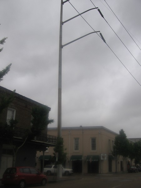
My apologies for the long lapse of time between Part I and Part II, but the act of collecting photos proved more challenging than I expected. In my previous post for this series, I briefly deconstructed the pros and cons of overhead electric wires, which offer the least expensive means of safely transmitting current, but at the cost of vulnerability to high winds and fallen trees, as well as the obvious visual disarray. Undergrounding the cables eliminates the unsightliness while protecting the transmission from interruptions after heavy storms, but broken underground circuits are harder to detect and costlier to repair. Most arguments on the relocation of cables usually reach a stalemate, but aesthetic interests nearly always favor their burial. Most suburban subdivisions built in the past thirty to forty years have adapted to an underground electrical network. Only in the most rural and low density developments will the marginal cost for undergrounding each housing unit rise to such levels that a developer cannot pass the expense to clientele and still produce a marketable product.The visibility of electrical infrastructure has become spatially polarized. It often appears that “modern” American subdivisions operate in a world without overhead wires. (The only wires typically straddle the edge of the neighborhood, along collector streets that allow entry to our wireless domestic enclaves.) The central cores of most cities—the historic downtowns—usually also enjoy sufficient density of electrical use to justify undergrounding. However, everything between the downtown and the suburbs of America’s historic cities—in short, the “inner city”—is replete with cables, wooden poles, and pylons. The concept of undergrounding scarcely existed at the time when these older urban neighborhoods were fashionable. By the 1970s, when undergrounding for new construction first became prevalent, the investment cost in burying wires in these mature communities hardly seemed worthwhile, since the middle class was fleeing them in droves. Now that the majority of Americans live in suburbs, one could argue that a preponderance of residential communities in which people live have underground cables, even though the overwhelming majority of land coverage—the inner city and the vast stretches of rural settlements—remain dependent on overhead wires. The configuration of overhead electric systems in New Orleans, my featured city, hardly differs from most other places: the downtown and newest suburban subdivisions have them buried, while hardly anything else does. But the “undergrounded” portions of the city seem particularly small, and many areas that one would typically expect to feature buried cables remain triumphantly elevated a hundred feet above street level. Convention Center Boulevard stretches across the edge of the city’s Warehouse District, which rests fully within the boundaries of the Downtown Development District. Yet it has overhead cables of a magnitude and prominence that one would only expect to see along a major highway in the outlying metro area. Just look in either direction:
 They’re huge. Intimidating, even—and taller than many of the three-story commercial buildings in the area.But how do they rate as a logical means of circulating electricity throughout the region, considering the constraints imposed by the city’s climate? New Orleans struggles with its propensity to suffer powerful, hurricane induced winds. After all, Hurricane Katrina left over 80% of the city without power for months. One might think that either the Department of Public Works or the private utility providers would seek to underground more of the wires. But most of the city rests below sea level, and essentially all of it sits in a floodplain, making the buried wires equally susceptible to soil saturation. Any lawyerly investigator would naturally respond: “Cities in Holland, such as Amsterdam, found a way to bury the overhead wires, even though they sit below sea level. So why can’t New Orleans do it and help minimize power outages after major storms?” The simplest answer would be that Amsterdam—and all of the Netherlands—has installed a complex flood protection system that essentially shields them from the North Sea tidal surges, so that only a natural force once every 50,000 years is likely to cause flooding. In short, Amsterdam could enjoy buried cables because it has virtually eliminated the chances of water intrusion. When the Army Corps of Engineers’ upgrades to New Orleans’ levees and pumping stations are complete, the city should experience a 1% chance of flooding each year—an astronomically higher risk than Amsterdam. And this is the city’s aspiration in a post-Katrina landscape. Because of its subtropical latitude and proximity to the Gulf Coast, New Orleans will always be more susceptible to failure of its flood protection system: in fact, the sophistication of Holland’s system, if transferred to New Orleans, would still only be good for protecting in the type of flood that occurs once every 500 years. Hurricanes are fundamentally more violent than anything Holland will ever likely suffer, and the technological advancements to protect New Orleans at the same degree as Amsterdam simply do not exist, or they are permanently outside of any municipal, state, or federal budget.Skeptical lawyers may raise their hands again: “Nearly all of New Orleans’ street poles parallel the sidewalk and the street curb, so the wires essentially criss-cross the street, and poles obstruct the view of houses. Why couldn’t the utility companies have originally laid the wires behind the homes in the back alleys, as they often have done in the old residential neighborhoods of other cities?” It’s a valid criticism. Just look at the pictures below:

 Observe how these Victorian shotguns must get their electric lifeblood right below the gutterline, at the location of those quintessentially ornate New Orleans brackets:
 This configuration is hardly unique to New Orleans; plenty of other old neighborhoods in American cities have utility poles in the front yards of the residents. But in many cases in New Orleans, the poles only line one side of the street, and homes on the other side receive their juice through a bundle of wires that leapfrog across the lanes, or radiate outward from a single pole that serves as a vertex for distributing the current.
 That’s a lot of wires. Compare this to a city like Chicago, where many older neighborhoods still employ overhead wires, but they are carefully tucked behind the homes in the back alleys and are virtually inconspicuous when walking or driving along a local street. Take the 3300 Block of North Hoyne Avenue, in the Roscoe Village neighborhood of Chicago. A photographed street section looks like the image below, taken from Google Streetview:
 Compared to a typical New Orleans residential street, this block in Chicago is bereft of overhead lines. But they have not been buried. Look slightly above and behind the homes on the left side of the street. The secret to Chicago’s comparatively inconspicuous overhead electrical grid is that it falls behind the homes, parallel to the back alleys. The back side of 3300 North Hoyne is visible below:
 The wires radiate to each of the residential units from the central artery of cables hoisted by wooden poles, but their location in the back alley makes them barely conspicuous from the street out front—presumably the side in which most people would prefer showcasing their homes. No electrical poles blocking the façades either.Chicago’s placement of the poles on nearly all of its streets is orderly, efficient, and subtle. But the city’s entire street network could claim two of those three adjectives as well. The relentless grid is orderly, efficient, and anything but subtle, as it is patently obvious to even the most uninformed viewer when flying overhead. Here is the network for Roscoe Village and its environs:
 Chicago blocks are fundamentally rectangular based, or—one could argue—bisected squares. Homes front the long side of each quadrilateral, while the entrances to the alleys fit within the short side. Thus the alleys on the 3300 block of North Hoyne—and the power lines—fit into the block structure like this, as indicated by the red markings:
 This grid replicates itself across the entire city, with few deviations—it is essentially an extension of the range and township line system originally platted from the Land Ordinance of 1785. Zoom out just a bit to see these bisected squares writ large.
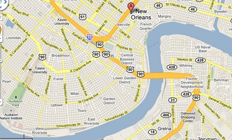
 While by some metrics, the grid is so repetitive that it makes navigation in Chicago more monotonous than it otherwise would be, it certainly makes it less difficult as well. It also facilitates the linearity of the overhead wire network in place in Roscoe Village and numerous other neighborhoods.New Orleans by and large adheres to a grid network as well, but it is hardly as straightforward. One of the main reasons the city has earned the nickname “the Crescent City” is because of the concave bend in the Mississippi River which forms the basis for a continually reconfigured street network, visible in the map below:
 Gridlike it may be, but virtually no one would claim it is an easier city for navigation than Chicago. The network routinely re-orders itself based on the serpentine path of the Mississippi River to the south. Arterials like Claiborne Avenue and St. Charles Avenue parallel the sinuous curves but still operate as the closest thing to a direct route: thus, an unacquainted visitor may think he or she is going straight along these streets—and most cross streets run perpendicular to them—but, if one watches these streets up to the horizon line, they follow a subtle arc. The result encompasses a series of grids that radiate outward from an unarticulated in triangular portions, like the folds of an Asian fan. For navigational purposes, it is virtually impossible to travel north or east as the crow flies, and it is equally difficult to provide directions using the conventional language: instead of “north”, locals will usually say “upriver” or “downriver”.Zooming into a New Orleans grid makes it clear how different it is from Chicago.
 The fundamental geometry is a square, not (as in Chicago’s case) a rectangle or a bisected square. The two long sides of a Chicago rectangle offer the front-door access to the homes and the two short sides provide access to the alleys, garages, and concealed overhead wires. New Orleans’ blocks lack the frontage hierarchy of Chicago; they are more egalitarian, and all four sides of the square typically provide access to homes. If I stare down the length of a block—any block—in New Orleans, this is what I see.
 Very few curb cuts, and no alleys. With the exception of a few select blocks in the oldest neighborhoods—The French Quarter, Warehouse District, and Faubourg Marigny—New Orleans is comparatively lacking in rear access to property the way an alley-dominated city like Chicago is. A further zoom-in to the Uptown neighborhood more clearly reveals the configuration of parcels and property lines within each block, and it’s hard to spot any real pattern.
 I can only begin to speculate exactly why New Orleans has such an irregular block system, but it largely echoes the anything-goes approach toward housing development that New Orleans has long adopted. As I walked along about eight blocks in this generally upper-middle class section of Uptown, I could witness a far greater diversity of housing types than one would expect in a similarly sized neighborhood in Chicago. As the two home photos above demonstrate, it’s interesting to see where homeowners decide to place their cars when they typically lack garages or carriage houses out back. Homes aren’t spaced as close together as they often are in Chicago, so some people squeeze a driveway to the side of the lot.
 Others simply convert their modest front yards to parking spaces:
 Still others preserve the fringe of greenery and settle for parking in the street.
 My investigation as to why New Orleans lacks alleys has figuratively backed me into dead-end one—I can’t find any real answers. But I can guess. Unlike Chicago, in which large tracts were platted and developed with parcels of equal size and housing catering largely to a single economic group, New Orleans’ neighborhoods are a pastiche of irregular lot sizes, homes of widely variable scale and quality, and a seemingly arbitrary mix of uses. The result is—and has always been—that the wealthy and poor more frequently live cheek-by-jowl than in most other American cities. (It could also explain why New Orleans appears to be among the less broadly segregated cities in terms of housing and race.) Many wealthy old families from Uptown wanted their slaves (ahem—servants) to live in close proximity, if not on the premises. Instead of an alley and a garage, the back sides of many homes feature a smaller, semi-detached unit that once served slaves’ quarters. The resulting arrangement of parcels in blocks makes it nearly impossible to draw straight lines across parcel boundaries in New Orleans, and particularly hard to limn a dedicated utility easement behind the properties. The agency installing the poles and wires would have to zigzag out of different parcel lines in order to furnish an electric network in the back yards of people’s houses. Thus, the city’s leadership decided long ago to install virtually all of its electric poles in the only place where straight lines where relatively feasible—in the front, right along the sidewalk.New Orleans faces a twofold dilemma, or four-fold, since all dilemmas have a duality to them. It would be wise to bury the cables to protect them from the strong winds of hurricanes, but then they’d be that much more vulnerable to inundation from floods. It would be lovely to conceal them in the alleys like Chicago does, but by and large it does not have alleys. The City most likely can never aspire to remove the overhead clutter in most of the old urban neighborhoods. How, then, can it come to terms with the mass of exposed infrastructure that comprises a typical street scene? The answer is simple: foster a culture around it that nullifies the idea that it is ugly, messy, or archaic. Celebrate it.In the third and final section, I will focus on the most cost effective solutions for dealing with the visual pollution of infrastructure, using New Orleans as a model and revealing that it has far less of a hurdle to jump than it may initially seem.
Low density and vast distances of sparse population have fostered a North American landscape in which much of the infrastructure remains supra-structure. Unlike much of urban Western Europe, most American and Canadian cities are pierced with wires hoisted above the sidewalks by either wood poles or, in more exurban areas, by steel pylons. Though overhead transmission through wires or aerial cables remains the least expensive means of conveying electricity, it has increasingly morphed into a form of visual pollution among the collectively conscious. Thus, many large European cities long ago resorted to undergrounding the wires in order to limit the clutter at the horizon line, while also protecting transmission from interruptions caused by snapped wires, induced by a fallen tree or strong winds. Conversely, metropolitan America is filled with these wires; in most of the country, the cost for undergrounding a few wires outweighs the aesthetic benefit.Exceptions to this trans-Atlantic dichotomy do exist—in the US, the most prominent parts of downtowns have underground overhead wires, as do the more recently built residential subdivisions over the past thirty years. Cultural attitudes here clearly seem headed in the same direction as Europe, since nearly all developers in suburban areas where the majority of new housing is built bury the cables for a residential subdivision in order to make their product more marketable (and then of course pass that cost on to the consumer). But nearly all of the “inner city” of metropolitan America—with housing built from the late 1800s until about 1975, as well non-commercial districts of suburbia—still plays host to a variety of methods for overhead electric transmission. To the average observer, overhead cables may seem old-fashioned or less advanced, particularly since they are less prevalent in more contemporary housing developments. But they are not necessarily a technical improvement in every regard: while overhead wires are more susceptible to damage and power outages from wind and falling debris, underground cables are vulnerable to water intrusion or disturbances through uprooted trees. Although power failures with overhead wires are more frequent, underground outages are often longer, more costly to repair, and more difficult to locate. Besides, all transmissions both above and below ground originate at substations and power plants and are therefore never fully undergrounded.I’ve pondered this predicament before, after encountering an unlikely power pole in an overlooked spot on Vanderbilt University’s campus in Nashville. The final argument on above ground versus buried cables nearly always hinges on aesthetics, and most people think a landscape looks better without a series of black, parallel horizontal strips, these viscera that nourish modernity. But who’s left to defend the overhead power line? If a coterie of classic infrastructure-lovers were to band together, what would be the epicenter of their crusade? A good place to look might be New Orleans. No city in the United States that I’m aware of is as “unburied” as the Crescent City. Those cables are everywhere. Granted, it appears that the core of the CBD, between Canal and Poydras Streets, has been undergrounded. Parts of the French Quarter and Warehouse District also have relatively few conspicuous cables. But at the portion of the Warehouse District closest to the waterfront, directly abutting the Morial Convention Center, the power poles are enormous. The photo above barely does it justice, but perhaps these below help.
 It contributes a dramatic conflict with the evenly spaced palm trees along Convention Center Boulevard.
 But it’s far more extreme in the residential neighborhoods outside of the CBD, such as this typical intersection in the Faubourg Marigny:
 In the second part of this post, I’ll explore the broader cultural influences on the New Orleans street grid and the placement of its power lines, as well as the psychological implications for undergrounding in a city with the ground upon which it rests is distinctly fragile. Stay tuned; you might find yourself involuntarily ducking.
If you've tuned in the past few days, I've been gradually tweaking the appearance of the blog to give it a bit more personality. This announcement serves as an indicator that I'm finish making these adjustments for now. No doubt I'll alter the appearance again in the future, but too frequent appearance changes only serve to erode the identity. So, this is all for now.
As I approach my tenth month with this blog, I again want to thank the followers, commentors, and general supporters--thanks for helping me stay alive with fresh posts, even as my own workload has grown a great deal. Keep it up, and I intend to keep the dialogue going for many moons.
This blog is due for another photo montage, and while the subject this month is hardly original, it remains one of my favorite: the always fascinating dying mall. I’ve explored several examples in the past: two in Indianapolis and one outside of Detroit. But dying malls are hardly relegated to the Midwest—all across the country, a number of regional enclosed shopping centers have met their demise over the past twenty years. So now it’s time to focus the lens on one in the South. I’ve referenced the Cortana Mall at Baton Rouge obliquely through a previous post; this time I finally visited it with a carefully hidden camera. Dedicated in 1976, the Cortana Mall (formerly Mall at Cortana) opened about 6 miles west of the Baton Rouge City Center, in a section from the old Cortana Plantation parcel, at the intersection of two arterials, Florida Avenue (U.S. 190) and Airline Highway (U.S. 61), indicated by the purple letter A on the map.
 Originally nearly 1.4 million square feet, it was the largest mall in the state, and in 1981 it expanded by over 200,000 more square feet, when one of the early department stores added a second level. A more detailed history of the mall is available at Mall Hall of Fame.The mall endured several battalions of new competitors over the ensuring two decades, but nothing unseated Cortana from its dominion as the pre-eminent mall of the Capital City region. However, in 1997, developer Jim Wilson and Associates opened the Mall of Louisiana to the southeast of the city center, along the mercilessly well-traveled Interstate 10 corridor, at its interchange with Bluebonnet Boulevard, indicated by the blue B on the map. Cortana Mall was dethroned.
 Cortana didn’t die overnight; thirteen years after the unveiling of the Mall of Louisiana, it remains open. Within a year after the competitor stole the spotlight, Cortana Mall underwent a mild renovation and changed its name to Mall at Cortana; it returned to Cortana Mall last year. Truthfully, this Mall has persevered as the “other mall” in Baton Rouge metro for a remarkably long time. Aside from the Mall of Louisiana, other formidable competitors include the lifestyle center Towne Center at Cedar Lodge (2005, just a little over 2 miles away, the green letter C on the map), the Tanger Outlets in Gonzales (an outer suburb 21 miles to the southeast along I-10), and the recent lifestyle/apartment/office hybrid Perkins Rowe (2008, just a mile south of Mall of Louisiana, also on Bluebonnet Boulevard at the purple letter D on the map). It is no doubt a testament to the solid population growth of metro Baton Rouge that Cortana Mall has been able to endure this long. When I first visited in 2005 (which I briefly referenced a few months ago), I could tell that it was the downgraded mall—quite simply, it lacked the upscale stores such as Banana Republic, Brookstone, Talbots, and any of the other solidly upper-middle tier stores present at Mall of Louisiana. Nonetheless, it seemed generally bustling around Christmastime, with relatively low vacancy except in the wing of in-line stores that lead to the notorious Sears. But that was nearly five years ago. How does it look today?


 It’s seriously hurting, with about 50% occupancy, I would guess, among the in-line stores. And in answer to the question posed by the title of this blog, they don’t really do mall rot that differently in the South than anywhere else, by my observation. Among the few tenants currently entering the mall are fourth-tier brands without any major advertising presence, like Famous Labels seen below:
 This is precisely the sort of tenant that seeks a struggling retail outlet, because that caters to the lower income market that still shops here. The well-heeled of Baton Rouge stopped patronizing Cortana long ago, and now the foot traffic and ensuing sales per square foot are so low that the place cannot ask for high rents. Famous Labels is a discounter that feeds on the rejected space of former top brands; no doubt this space once held a Lane Bryant or New York and Company. Notice from the photo above how much of the space inside the store is vacant; the tenant doesn’t even need to stuff the premises with merchandise because rents are low. Stepping back several feet from the store’s entrance reveals its less-than-lucrative surroundings:
 Beyond this, many of the other in-line tenants are most likely locally owned and operated. They would never be able to afford the rents in a thriving mall.
 The tenant in the background of the photo below is a convenience store, with gas station merchandise. Would you ever see that in a successful mall?
 Cortana hasn’t lost all of the big names; a few are hanging on. The neon is barely visible on the photo below, but the two tenants seen here are Pacific Sun and Journeys.
 And two more mall mainstays, Hot Topic and Wet Seal:
 The targeted demographic for these stores suggests that, at the very least, teenagers still frequent the mall. But how much are you willing to bet that not one of these will renew its lease when the term ends?And then there’s Aeropostale, another bit of a surprise.
 But for some reason, I’ve noticed Aeropostale hangs around dying malls longer than its perceived competitors. I’ve never shopped at the store, but I used to think it was comparable to American Eagle or The Gap; however, those two retailers tend to dart out of a mall at the first sign of failure, while Aeropostale does not. Most likely that means Aeropostale has cheaper merchandise. Bath and Body Works and Victoria’s Secret, both present in Cortana (though I did not take a photo), also hang around longer than one might expect. And shoe stores like Foot Locker are usually among the last big names to jump ship. I enjoy what the property managers of Cortana, creatively named Mall Properties, have decided to do with some of the vacant storefronts:
 These TV screens advertise the remaining in-line stores still standing in the mall.What about the department stores? At its peak, the mall boasted six anchor tenants, an incredible four of which were housed in two-story structures. Today, four occupied department stores remain: Sears, Macy’s, Dillard’s, and J.C. Penney. Mervyn’s closed a few years before the company went out of business in 2008, while Steve and Barry’s prevailed at the mall until near the end of the company’s life; it was defunct in 2009. But what about the surviving anchors? Since anchors typically pay little to no rent in a mall, they have less at stake and can often break even as long as they sell enough merchandise to pay their employees and cover basic operating expenses. But the Dillard’s at Cortana is clearly feeling the pinch. It’s housed in one of the two-story spaces, but the second floor seems to be receding.
 The partitions are blocking about 1/3 of the gross leasable space on this level. A conversation with a clerk revealed that they were liquidating the central portion of that floor as well, seen below.
 Before long, only the other 1/3 of that floor would remain open. Access to the second floor is already limited, as witnessed by this barricaded escalator.
 How much longer before Dillard’s vacates its second floor altogether? And then, of course, how soon before it bids adieu to Cortana Mall?Perhaps one of the clearest indicators that this mall is a goner is one of the smaller wings leading back to the parking lot.
 The theme of this wing seems to be Public Sector.
 It houses an Army Recruitment Center, Navy Recruitment, Air Force, and a US Postal Service Branch. No doubt these government agencies wouldn’t be paying the rent at Mall of Louisiana. While I hate to bring the specter of social class into this argument (and certainly don’t want to politicize it), the presence of all these recruiting centers can’t help but recall Michael Moore’s trip to an Army Recruiting Center in his hometown of Flint, Michigan in Fahrenheit 9/11. He recognized that the recruiting centers never appear on the “good” side of town, where the teenaged shoppers are most likely to have college aspirations.So, on a scale of 1 to 10, with 10 being the highest and most successful, Cortana’s placement is probably about a four or a five. It’s not dead yet, a few strong tenants remain, and some recent news that a Sam’s Club proposes locating at an outparcel on the mall premises offers a whisper of good fortune in this bad economy. But the fact remains that any mall that sinks below about a 7 out of 10 is likely past the point of no return, and what this means for Baton Rouge is the confirmation that the growth patterns are veering further away from the eastern suburbs and more to the southeast, along the I-10 corridor. It makes sense, in a way: living closer to a limited access road such as I-10 (rather than a busy six lane highway like Florida Boulevard) helps the commuter. And Louisiana State University, the true heart of Baton Rouge, already lies to the south and southeast of the city center. But the housing around Cortana Mall—particularly to the immediate south—is still solidly middle class. How long will it remain that way if the families have a blighted mall presiding over them? Will they be able to sell?The decline of Cortana is more remarkable because it remains a larger shopping center than the successful Mall of Louisiana, which is about 50,000 square feet shy of its predecessor in GLA. But it’s clear that the decentralizing forces in Baton Rouge have long favored the southeast. The northern section of Baton Rouge is overwhelmingly lower income minority. The western suburbs, across the Mississippi River, are mostly working class and growing slowly. The eastern suburbs comprised a middle class boomlet as recently as the early 1990s, but they haven’t been able to compete in desirability of the I-10 corridor. And since the Mall of Louisiana is the second biggest in the state, it has even become an attraction for folks in New Orleans over 70 miles away; it’s proximity to the interstate makes it far more accessible than the Cortana Mall ever was. But the poor folks in the north and west of Baton Rouge have always had a long hike to get to any major shopping; before long, even the sprawling suburbs of the east will have to travel much further to get to any major retail node. The death of Cortana Mall represents the culmination of some of the most lopsided decentralization patterns of any metro region I have seen. It is an apotheosis of Homer Hoyt’s sector theory, in which settlements expand in wedge shaped patterns along principal transportation routes. There’s nothing wrong with this per say, but the problem with most urban growth theories is that few cities actually live up to any of the proposed patterns. But here’s one example that has followed it almost hook, line, and sinker. Maybe that’s just how they do it Down South?







 Posts
Posts


