
Showing posts with label lighting. Show all posts

Thursday, February 27, 2014

A chip off the old bulb.

Seven months after the announcement, it still seems like the largest municipal bankruptcy filing (at least up to this point) is the stuff of legend—the culminating event, after successive blunders.  The apex.  Or the nadir.  No doubt those of us living here are guilty of a degree of chauvinism as we experience how it plays out firsthand, but it’s easy for anyone with even moderate media curiosity to see how much the city has hogged the headlines.  It may be for all the wrong reasons, but Detroit is prominent once again.


Yet it was only weeks—if not days—after the declaration made international news that, in order to convey to the world the magnitude of the city’s financial woes, journalists honed in on more mundane failures—failures that, by virtue of their banality, were all the more shocking.  Locals have known about them for ages.  A portfolio of abandoned public school real estate larger than many cities’ functional school systems.  An absence of snowplows, even after heavy storms.  A stonewall of silenced civil servants, hogtied from effectively carrying out duties by daily uncertainty about the security of those same jobs.  The virtual absence of any emergency response, resulting in two-hour waits for an ambulance or a police call.


But the one that crowds out the rest, no doubt at least partially due to its ubiquity and ordinariness, is the persistent non-functionality of those streetlights.  One of the editorialists for the Free Press has branded it “the city’s deepest embarrassment”.  By most estimates, up to 40% are out on any given night.  Anyone passing through can tell when crossing into the city limits for this exact reason: even huge stretches of the interstates are black, although they’re state or federal highways.  It’s hard to determine if these shadowy streets originate from a cash-strapped DPW’s inability to replace the bulbs—which obviously require periodic maintenance—or an oversight that far precedes the checkered Kilpatrick administration, when the city’s fiscal woes first garnered national attention.  All it takes is a trip down Mack Avenue on the city’s east side to postulate that the problem is a half-century in the making.
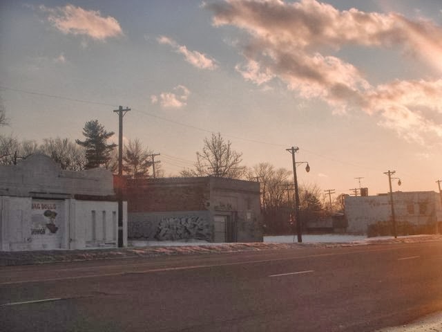


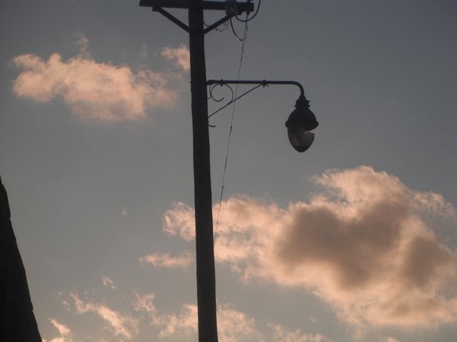
Silhouettes of streetlights punctuate the dusky penumbra, but even at a distance, the shape of these lights seems odd.  Antiquated?  Probably.  And a closer view confirms it.


To be frank, I can’t recall seeing lights like this before anywhere else in the country, and I’m well-traveled across some of the more economically deprived pockets.  From the baroque iron filigree work of the stanchion to the acorn shape of the light itself, my guess is this streetlight comes from an inventory that most cities had fully retired over three decades ago.  And there’s probably good reason for that: this one is broken.


And so is another one half a block away.

About half of the lights along this stretch of Mack use this design, and most are cracked.  A big distended bulb offers more surface area encased in glass—more space for something to wrong.  Whether hit by flying debris hit or (my suspicion) deliberately smashed by a passer-by, this streetlight is almost definitely non-operational.  And the visible hardware is only half the problem: inside that quaint, clunky bulb (your grandmother’s streetlight) is—or was—a mercury vapor lamp. Detroit is one of the few cities that still depends heavily on this less efficient, increasingly obsolete method of illumination; most other large cities have replaced their inventory with superior metal halide lamps.   USA Today also noted that Detroit and Milwaukee share the dubious distinction of being the only large cities that still deploy series circuits for much of the streetlight network, meaning that if one transformer box breaks down, the whole strip of lights goes dark, like an old string of Christmas tree lights.  While the Mack Avenue streetlight featured above remains attached to a wood, other lights in the city append to metal poles, presumably the same age as the lights themselves, characterized by rust, peeling paint, and sometimes even open cavities at the base.  The whole contraption has seen better days.


But viewing these cracked eggs through a cultural lens can help temper some of the scorn.  They might not work well as modern lamps and they’re much easier to vandalize, but they’re relics—they’re curiosity items.  And they’re particularly eye-catching along Mack Avenue because there are so many of them, yet they’re still interspersed with more contemporary designs.  This cool pic doesn’t win awards for clarity, but it still shows the juxtaposition of old and new streetlights, through their silhouettes.


Or on opposite sides of the street.


And on a depopulated residential street not so far from Mack, a different kind of lighting style emerges—perhaps not as old-fashioned but still an oddity.


Perhaps a style and technology that never caught on?


The irony of the 1950s-era (or maybe even 1940s) lighting that lingers on in Detroit is that, in a broader spatial context, it exemplifies technological advancements playfully defying shifts in taste culture for a particular design.  On Mack Avenue, ancient streetlights bespeak a broke, ineffective government.  And yet, elsewhere in the metro, they convey something else.


Forgiving the quality of the photo, it’s still easy to see a similar style of lighting to the ones on Mack Avenue, but this time they’re impeccable.


But this is the comfy suburb of Livonia, presumably part of a streetscape improvement along a thoroughly auto-oriented corridor of strip malls and big boxes.  And they no doubt were a deliberate choice from the Public Works Department because they look good—providing a vintage, old-timey feel.  Apparently they don’t worry in Livonia about ne’er-do-well pedestrians throwing rocks at these distended bulbs.  Maybe it’s because Livonia has few ne’er-do-wells….and even fewer pedestrians.  But even some of the economically healthier neighborhoods within Detroit have caught the bug, replacing older streetlights with a newly vintage design, like these twin lamps in Midtown, near Woodward Avenue:


This inversion of taste cultures pervades streetscapes across the country, where everything old is new again, in order to exploit nostalgia among a generation that never really experienced a normative walkable environment—a landscape that was still the standard during the era when city crew first installed those acorn mercury vapor lamps.  We’re seduced by nostalgia and novelty; a hybrid of the two is doubly sweet.  Just go to the French Quarter in New Orleans, where a city equally negligent in modernizing its utilities now capitalizes on this same inertia—the flickery gas lanterns that once were a backwater embarrassment are now ambiance.  Detroit isn’t yet so lucky to take similar advantage of its obsolete lighting (and the fact that most streets like Mack are a hodgepodge of styles doesn’t help), but that doesn’t mean that an emergent cultural voice won’t someday call those lights “genuine retro”, and the preached-upon choir will be listening.


The periodic “freshening” of basic urban infrastructure is only partly due to necessity, as it may very well be in Detroit.  But a great deal simply has to do with keeping up with the joneses, resulting in often needlessly costly capital investments.  For example, the standard for pedestrian signals at intersections now typically involves a “countdown” timer, telling pedestrians exactly how many seconds they have left to cross.  While useful, are these timer boxes essential?  Regardless, public works departments are rapidly phasing out the single-box approach for these new timer-boxes, with little evidence of public advocacy one way or another (despite the fact that the public inevitably is paying for most of these replacement costs).  From decorative viaducts to Day-Glo yellow road caution signs, jurisdictions hell-bent on an infrastructural one-upmanship should look to Detroit as an inverse exemplar—what might happen when profligacy goes perpetually unchecked.  Unless, of course, these granny-and-gramps streetlights become hip and cool again, in which case the Motor City might have the last laugh.


Saturday, June 30, 2012

Not all interstate highways are perpetuated equal.


While transportation infrastructure has long elicited a highly politicized debate in the US, particularly in regards to government funding of alternative methods (Amtrak and rail, supporting the persistently ailing airline industry), only in recent years have the discussions migrated more heavily toward inadequacies in road and highway infrastructure.  The collapse of the Interstate 35W bridge in Minneapolis in August of 2007 helped stimulate the Federal Highway Administration to probe into the quality, level of maintenance and fundamental stability of some of the nation’s most heavily traveled bridges, while it prompted the Minnesota Department of Transportation to increase the state fuel tax mildly to fund bridge maintenance appropriately.

Five years later, the debate on the adequacy of transportation infrastructure funding persists: the most comprehensive current authorization of funds is the Safe, Accountable, Flexible, Efficient Transportation Equity Act: A Legacy for Users, better known by its acronym SAFETEA-LU.  First signed by President Bush in 2005, it expired in September 2009, but Congress has extended it more than a half-dozen times since then.  The latest (ninth) extension expired today (June 30, or yesterday, depending on when this blog makes it to post), and while Congresshad long aimed to pass a final reauthorization bill, it seemed more likely, in this heavily fractious political climate, that it would simply settle for one or two more extensions until the November elections.   However, to many people’s surprise, President Obama was able to sign into law a bill that at least for the next week (until July 6) assured that no interruption to federal highway funding would take place.  It now appears most likely that a new bill will emerge in the next week, rather than yet another short-term extension.  For most Americans, none of this is particularly earth shattering news: only institutions with strong ties to lobbying are likely to follow the development of this bill on a day-to-day basis.  My suspicion, in fact, is that over 90% of Americans would not know what SAFETEA-LU is.  Does this seem strange, given our overwhelming dependence on the interstate highway system for traversing this mammoth country?

It may be premature for me to accuse Americans of prevailing complacency in this matter, but obviously there is a far greater confidence that the legislature always will do something about this, and the impact of that decision is not going to cause widespread polarization among the constituents.  Compare the passage of this bill to the results of the Supreme Court decision on the Affordable Care Act: everyone has been glued to their TVs!  The “complacent” label may seem snide, but it was certainly a word Minnesotans heard a fair amount in the summer of 2007, and it wasn’t targeted at residents of that state: negligence and indifference toward infrastructural needs was a nationwide problem back then, and it remains so today.  After MnDOT devised alternative transportation routes during the reasonably fast paced (13 month) reconstruction of the I-35W bridge, did we resume our blithe disregard?  Was the loss of 13 lives during that collapse simply not significant enough to confront the problem the same way we have confronted the funding of health care?

Looking across the recent improvements in our highway system, it’s hard to conclude that improvements in the Federal Interstate Highway System operate under a consistent authority—most likely because they don’t.  I-65 as it runs through Kentucky offers an excellent example.
As the image above indicates, this stretch of the 887-mile highway weaves between Kentucky’s undulating hills and limestone beds.  Just a few miles later further south, the landscape is virtually unchanged.
Perhaps a little flatter, but not much different than before.   This is how most of I-65 in Kentucky looks: with few exceptions, the interstate passes through overwhelmingly rural countryside.  Kentucky in general is not a terribly urban state: only one metro, Louisville/Jefferson County, ranks in the nation’s Top 50 for size, and only four cities (Louisville, Lexington, Bowling Green, Owensboro) claim populations over 50,000.  The state ranks 22nd inpopulation density, but at 110 persons per square mile, it is less than a tenth as densely populated as some of the crowded northeastern states such as New Jersey and Rhode Island.  While traffic volumes for I-65 through Louisville are undoubtedly high at peak hours, the only two other communities of reasonable size (populations over 15,000) with exits along the I-65 stretch of Kentucky are Elizabethtown and Bowling Green.  These are the only communities outside of metro Louisville along the interstate that offer a choice of services (gas, food, lodging) beyond the bare minimum—quite a few of the already sporadic exits along I-65 offer nothing at all.

In short, Kentucky is not a particularly crowded state.  But most of its share of I-65 would suggest otherwise.  Through much of the Midwest and South, six lanes is reserved for more urbanized areas.  The only portions of I-65 in Indiana (a state with nearly double Kentucky’s population density) that are more than four lanes are the Indianapolis metro, NE Indiana around Gary and Merrillville, and the Louisville suburbs in southern Indiana.  Ohio, the tenth most densely populated state in the country, also claims huge stretches of rural interstate highways that are only four lanes wide.  But in recent years, Kentucky’s DOT has overseen the widening of nearly all of I-65, with the exception of a 43-mile segment south of Elizabethtown and north of Bowling Green, and the Governor articulates proposals for an upgrade there during the FY 2012 – FY 2018 Highway Plan.  Before long, all of I-65 in Kentucky will be at least six lanes wide.

Another noticeable feature is the superior lighting of I-65 in Kentucky across its exits.
Streetlights are numerous at the exit ramps, even if the intersecting street does not host a great deal of services or traffic.  In Indiana and Ohio, only the busiest of rural intersections get streetlights, and their number often depends on the traffic volumes: those with a variety of hotels and restaurants may have a dozen streetlights, those with only one or two gas stations may have a half dozen or less, and those that are the most rural will have none.  Conversely, in Kentucky, virtually every interchange on I-65 is now fully saturated with lights—urban or rural, and most are still resolutely rural.

When passing near Bowling Green, where the exits are often quite a bit busier, the streetlights are even more numerous.
Bowling Green is a moderately sized city of approximately 58,000 inhabitants.  Cities of such a size in either Ohio or Indiana are numerous, but in Kentucky, Bowling Green is the third largest city.  And between its three primary exits off of I-65, the segments of interstate remain consistently well-lit:
This stretch of highway deploys of stanchions in the median of the interstate, planted firmly in the Jersey barriers at short intervals.  Usually only larger metros of over 250,000 would integrate such a lighting technique, and exclusively when the interstate passes directly through the most urbanized area.  I-65 circumscribes the exurbs of Bowling Green, yet motorists still get some big-city lighting.  Indiana’s comparably sized cities—Anderson, Lafayette, Terre Haute, Muncie—only get lighting at the major exits.  Granted, the respective interstate does not pass directly through the hearts of those cities either, but the lighting is nowhere near as sophisticated.  Ohio shares the same condition as Indiana, with many lightly traveled interchanges remaining completely unlit.  Thus, Kentucky, despite being a significantly less densely populated state, has invested in highway infrastructure at a level that far surpasses that of its more urbanized neighbors to the north.  I have no doubt that I-65 through Kentucky receives a number of travelers passing through on this very important corridor that connects Chicago to the Gulf of Mexico.  But the fact remains that Indiana and Ohio also can claim significant trucking traffic in addition to their much larger population bases.  Both Indiana and Ohio, because of their proximity to other large cities inside and outside of the two states, have accommodated a significant ground logistical industry, suggesting that, in aggregate, their interstate highway segments will remain much busier than Kentucky’s for the foreseeable future, however well-used it may be.

This comparative observation by no means intends to criticize the Commonwealth of Kentucky’s transportation spending decisions, nor those of Indiana and Ohio.  It simply demonstrates the visible differences in states’ priorities.  Kentucky’s Highway Plan includes the proposal for spending Road Fund revenues appropriated in each new two-year period, which includes state and federal gasoline tax revenues.  This has proven a highly volatile source during the serious recession, due to reduced fuel consumption and purchase of vehicles.  The Federal Highway Trust Fund has been particularly unstable, not only because of reduced consumer spending but because Congress has not agreed on a suitable alternative to SAFETEA-LU since it expired; the series of resolution/extensions disburse about 20% fewer funds than before the act’s 2009 expiration.

Even if many fundamentals of a limited access highway (design, safety parameters) remain more or less the same from state to state, the “embellishments” will inevitably vary tremendously.  At least for now, Kentucky has some of the most luxurious interstates in terms of lane widths and lighting, particularly in relation to the fact that so much of the state is sparsely populated.  By contrast, signage is less developed in Kentucky than in other states: few—perhaps none—of the overpasses in Kentucky have any indicator of what the name of the road is, whereas in Indiana, most overpasses do.  And in Alabama, virtually every street has a particularly handsome sign:
These signs are relatively recently funded—probably simultaneous with the highway widening in Kentucky—and they closely approximate the Clearview font approved by the FHWA to phase out the older, splotchier Highway Gothic.  Notice this example here, with the new font on the overpass and the old one to the right of the road:


Alabama has the slickest signs I have seen among my own recent road trips.  And at this point, Kentucky interstate driving is about as comfy as you can get: roads as wide as you expect to see in Connecticut, but with a fraction of the population density.   Meanwhile, Ohio and the Mid Atlantic states have invested much more heavily in protective fencing to prevent injury when motorists on the overpass might throw objects out the car so that they could hit people below.  Ohio has these fences on almost all overpasses; Indiana, Alabama, and Tennessee have them on just a few; Kentucky has none.  Will we ever see a consistency among the states in all of the various infrastructural amenities?  I’m not holding my breath, and while I hate to end on a cynical note, it is clear that some states are devoting greater amounts of money to bridge maintenance than others—time will only tell where, amidst a decentralized transportation funding system, the next Minneapolis will take place.


Thursday, July 29, 2010

MONTAGE: The Main Street of America goes Kansas.

"Thanks to the Interstate Highway System, it is now possible to travel from coast to coast without seeing anything." ~Charles Kuralt

The federal government might have decommissioned U.S. Route 66 twenty-five years ago, but you don’t have to be middle-aged to recognize the name, or even to appreciate it. In fact, the Mother Road seems to have only lodged itself more securely into the American consciousness with each passing year; I’d venture to guess that even most teenagers are at least familiar with its existence. Aside from the roadside businesses and concomitant folk architecture that this celebrated route spawned, it also helped to elicit a hit song by Bobby Troup, a successful TV series, a gas station chain (Phillips 66), heritage associations in each of the route’s eight states, and numerous books and museums. Disney’s hit movie Cars originally was going to be named after the iconic road. This original paved link between Chicago to Los Angeles/Santa Monica boasts contests to win tour packages in the UK, while the blogosphere is filled with chronicles from people of many nationalities who have taken the legendary road trip. Its mystique stretches across the globe, despite—and then because of—the fact that it is as Americana as Monopoly.

At this point, it’s amazing to think that, despite the tsunami of cultural references we confront each year, much of the built environment that this asphalt artery helped to sustain is decaying. And the decay began long before the official decommissioning; if anything, the slam of the hammer against the coffin’s nail only galvanized interest in saving what still survived. The historic neon-accented motels routinely fall into American and international preservationists’ most endangered historic places. They’ve lost their reason for being since so much of the classic two-lane highway has been upgraded into four-lane, limited access interstate, thereby choking the original businesses from the vast majority of transcontinental travelers. Its extreme popularity led to its upgrade to a limited access interstate under Eisenhower’s Federal Aid Highway Act of 1956, but this upgrade resulted in the near demise of the stop-and-go roadside culture. Last year, President Obama signed the Route 66 Corridor Preservation Reauthorization Act, extending a National Park Service program the essentially recognizes the upkeep of Route 66 is less a transportation or public works route and more a multi-state historic preservation ambition.

How well is it working? Federal aid is no doubt most visible through the improved/restored signage, with the emblematic logo resting on a backdrop of brown, which is usually the color for historic and cultural sites.

Alas, I have not traveled the entire trajectory of the Mother Road, but I can at least boast that I’ve been through more or less the entirety of Route 66’s path through Kansas: all 12 miles of it. Among the eight states, Kansas claims the smallest portion of the route by a long shot: all of the others get at least 100 miles, and New Mexico boasts nearly 500 miles. However, the entirety of Kansas’ portion remains a two-lane highway, passing exclusively through Cherokee County (the southeastern-most county in the state) and through only two real communities: Galena and Baxter Springs. The map below outlines in purple the path of Route 66 through Kansas, providing a brief link between the historically much longer portions in Missouri and Oklahoma.


Galena is an aggressively depopulating old mining town, with very little remaining of what was probably once an extensive main street. It may earn a blog post of its own. Riverton is an unincorporated community so small I failed to notice anything significant about it during the twenty seconds it took to pass through it. (Apparently the Eisler Brothers Country Store in Riverton is a Mother Road institution.) Far more prominent is the most southerly town in Kansas on the route, Baxter Springs, just a mile or so away from the Oklahoma Border.


The town’s main street is hardly flourishing, but it is alive enough to suggest that the community is trying—and virtually every establishment has some reference to Route 66. The photo series that follows only includes what is contained in the green rectangle on the map below:


Baxter Springs’ downtown is a mere three blocks. But the iconography of Route 66 is everywhere. I would expand upon this montage with a more detailed analysis, but many others before me have done a far better job. Among them is Arthur Krim’s Route 66: Iconography of the American Highway (2006, Center for American Places). My copy of this book is stored far away from my access right now; hopefully someday I’ll recover it and use it to enhance the analytical component of this blog post. In the meantime, I present Military Avenue, the main street of Baxter Springs, laden with references to the Main Street of America.


These banners appear systematically at almost every one of the streetlights of “vintage” design along the primary commercial section of Military Avenue in Baxter Springs. In hindsight, I wish I had taken more care to capture everything about these streetlights in one snapshot, but I didn’t. At any rate, even the street signs have the vintage Route 66 logo—an unsurprising but winsome touch.


All and all, the streetscape is spartan but clearly not neglected. Here’s the east side of the street:


And the west side:

The Historic District in its entirety isn’t terribly active, but it is generally intact, and although many of the buildings are shuttered or vacant, most appear fundamentally maintained.


Café on the Route has smartly tied its name to the heritage corridor upon which it rests, regardless of whether or not it’s a true Route 66 institution. I’m impelled to believe it is not: most of the genuine surviving establishments make no reference to the road in their names, because they pre-date the point when the road became a cultural artifact. This Café’s self-awareness suggests that its owners located here to capitalize on the legacy, and who can blame them? The building itself appears diligently preserved and includes an attractive mural.


To the left of the mural is a placard, indicating that building is within the purview of the Hampton Inn Save-a-Landmark program, an outreach preservation campaign involving considerable time and money, and the first example of a major hotel chain (Hilton) earning recognition for its preservation efforts. Apparently the Café on the Route’s building predates the Mother Road by over fifty years and was originally a bank robbed by Jesse James in 1876.


On the other side of Military Avenue stands the structure in the photo above, which according to this site on Kansas’ Historic Route 66, housed a true highway institution, Murphey’s Restaurant, until recently. The vinyl cladding and vintage sign, visible on the website, have clearly since been removed. It appears to me that the edifice is undergoing a renovation, having received what appear to be brand-new windows—a big no-no among preservationists if not conscientiously implemented, but a positive for Baxter Springs if it augurs a real reinvestment in the building. Traces of the old Route 66 logo still linger.


Apparently local artists have attempted to enliven some of the other vacant storefronts with references to the route in the windows:

Antique stores and flea markets, which appear to be the dominant uses along Baxter Springs’ main street, are replete with decal logos in the windows, or other Route-related bric-a-brac.


This may be the Café on the Route’s biggest competition:


This old Philips 66 no doubt stopped providing an oil change and tire rotation decades ago.

But the building is in excellent shape, and today it hosts a visitors’ center, which, judging from the sign, is less about Baxter Springs and more about the Route—a wise decision.

The lackadaisically run auto shop across the street from the center still took care to reference the Route.


But most remarkable in all of Baxter Springs is an apparently recent incarnation on the east side of Military Avenue: a soda fountain.

According to a local, the Route 66 Soda Fountain was funded through the Abernathy Charitable Trust and a children’s foundation. The Bill Abernathy Memorial Lifetime Learning Center operates solely as a 501(c)(3) organization, providing entertainment and activities to keep Baxter Springs’ youth out of trouble, as well as GED programs and adult education classes. Each vintage booth has outlets for laptops, and the place features high-speed wireless Internet. And it does serve ice cream, though I could not determine for certain if the building ever serves non-local visitors. It was not scheduled to open until later that evening, but peering in the glass, I witnessed what appeared to be an impeccable duplication of the soda fountains from days passed:


The highway continues southward from the historic district, along what is now labeled Alternate U.S. Highway 69, passing through what constitutes the modern-day commercial hub of Baxter Springs: Pizza Hut, KFC, O’Reilly Auto Parts, McDonald’s, and, a bit further down the road, a strip mall with a Dollar General and Wal-Mart.

I’m sanguine about the future of Baxter Springs. The commercial building stock is excellent and in good repair. The town’s boosters clearly know what its strongest asset is, and they have done their utmost to highlight it to passers-by. And most motorists passing through the town will be traveling along Alternate U.S. Highway 69—the historic Route 66—for utilitarian or recreational purposes. The utilitarian travelers are most likely on their way to something else, or perhaps they work in Baxter Springs. The recreational drivers are the key, and for nearly all of them, the route itself is the primary attraction, because it serves as a conduit to any sundry eye-catching curiosities along the curbs.

Perhaps Route 66 will experience, or is currently experiencing, a renaissance all its own. Maybe the Disney movie stimulated interest among a new generation. Maybe federal preservation grants are helping, but something tells me they are less than critical—they certainly aren’t mandating tour buses filled with Norwegians to pass through towns like Baxter Springs. This town in the corner of Kansas will find its modern reason for being by connecting with its past, which is as clichéd an ambition as there ever was. But while Baxter Springs’ history may be unremarkable or simply uninteresting on its own, the prominence of the Mother Road in American/global mythology gives it a competitive edge over another Kansas town twenty miles away. Baxter Springs is a stop on the quintessential road trip.

Monday, July 26, 2010

These lumps are always benign.

This blog post may be the closest I ever get to a real-time narrative. It’s not purely real-time, of course, any more than this is an online journal. But everything that this blog features occurred within the past few days, and fortunately I was able to document it photographically as I was experiencing it, including the crucial revelation at the end. I was driving from Monroe, Louisiana toward Little Rock, and, as anyone from these two states could tell you, there is not a single limited access highway or interstate connecting Louisiana and Arkansas. But if part of the goal is absorbing Americana through a camera lens, who wants to take interstates anyway?


I was venturing northward toward Pine Bluff, Arkansas on U.S. Highway 425, across southern Arkansas’ flat and impenetrable pine belt, just south of the college town of Monticello. The photo above is hardly an anomaly for being devoid of cars: this was the norm, and ten minutes could easily pass before I confronted another vehicle. If my driving got a bit sloppy—as most of us are wont to do when the roads are this barren—I might skim over the yellow painted lane divider, when I would here the familiar pa-dump pa-dump pa-dump of those reflectors against my wheels.


At any rate, it’s a familiar sound in a good part of the country, and apparently a common enough phenomenon that it approaches highway vernacular status. Facebook even has multiple groups devoted to people who try to avoid hitting them when they change lanes. I had learned several years ago that the patented design commonly employed in American highways is called Botts’ dots, after Elbert Dysart Botts, the California transportation engineer credited with their invention. However, this whimsical name often suffers from over-application, because Botts’ dots are a particular design rather than a general term—usually round and non-reflective, like the example seen in this photo. They serve as a purely auditory warning—for alerting motorists when they are crossing a certain threshold, usually a lane. Attempting to avoid them is fine—as apparently a few thousand Facebook users do—but it should not be done out of fear of damaging them, since the ceramic or polymer used in their construction can support the weight of a car. The square reflectors along this Arkansas highway also are made of a sufficiently durable material, meaning they serve a double purpose of providing both a lighted path at night and an audible warning at all times of day.

Despite the fact that US Highways and interstates receive federal funds for their construction and continued maintenance, not all roads are created equally. A major American highway can bisect several states and morph considerably along its trajectory—quite often these shifts are obvious when crossing into a new jurisdiction, such as a state or county line. Differences in soil quality, topography, climate, and jurisdictional road safety laws add variety to any transcontinental thoroughfare, and these pavement markers are no different. Departments of Transportation can clearly decide which safety features are most critical in their jurisdiction. In south Arkansas, square reflectors and Botts’ dots can protrude from the pavement:


As suitable as these devices are in an arid climate like southern California, they don’t work so well in upstate New York, or any part of the US that ever receives heavy snowfall: the plows would scoop these critters up. If they can exist at all in the North, they must be recessed in the pavement and further reinforced. I cannot provide a firsthand auditory comparison right now between protruding and recessed reflectors, because I haven’t been in the Frost Belt in awhile. But I suspect the trademark skip-thump sound would have to be muted if the device cannot protrude as much.

Later that same day from which the above photos were taken, I had to head westward from Little Rock along Interstate 40. By this time, it was pitch dark, and I have never felt so nervous about driving on an interstate in my life. I couldn’t pin it down at first, but something about this stretch of highway winding through the Ozarks induced anxiety. Eventually I realized that a number of features were missing that I often had taken for granted. This portion of Arkansas interstate does not in general use street lights at exit ramps. It has relatively few billboards--or, at least, very few of are illuminated. Only a few communities between Little Rock and Fort Smith have more than 10,000 inhabitants, so no ambient light from a neighboring community. But perhaps most critical, the center lane lacked any square reflectors. No reflectors in general—not on posts, not embedded in the pavement, and relatively few green reflective signs. It was dark. Clearly a driver’s headlights should compensate, but they only provide illumination for 50 to 100 feet or so. Driving that night through western Arkansas, I often couldn’t tell if the car in front of me was just turning to negotiate a curve or getting off at an exit ramp. These reflective squares critically promote safety because they show the trajectory several hundred feet ahead of the driver, allow him or her to prepare for curves. They only way I could anticipate curves that night in Arkansas was by turning on the high beams, which is arely permissible because traffic is much higher here than US Highway 425. Thus, a rarely traveled fragment of highway in the rural southern part of the state offers a better reflective environment than the interstate connecting Arkansas’ largest and second largest cities.

But why would the state’s Department of Transportation choose to use federal funds for reflectors on one highway but not the other more traveled one. Why snub interstates in Arkansas? My return trip during broad daylight (I wasn’t going to try that route again at night) provided the most likely answer:


In the near exact middle of the above photo, before the white stripe marking two different lanes, is a small indentation. I got as close as I could with my camera, given the high speed and frequency of cars passing by.


It almost looked like a scar where the reflector should be. But why is that reflector missing? Is it possible that the DOT, assuming that central Arkansas’ climate is warm enough, allowed the reflectors to protrude just as they might in Arizona or southern California? And could this have been the critical mistake that seriously deteriorates the safety of this Arkansas highway at night? Central Arkansas most likely does not endure heavy snowfall very often at all. But at one point, it did, and the necessity for making the road remotely passable by employing snowplows superseded the preservation of protruding square reflectors, Botts’ dots, or whatever they had once used here. They’re all missing. Just looking the other direction reveals the same scar where something clearly should be; it was snatched by a snowplow.


I could be wrong of course, but I can think of no other reason why this heavily travelled transcontinental highway would lack them. (The small patch of I-40 that I traveled in Oklahoma lacked them as well, but at least Oklahoma’s exit ramps had streetlights. Maybe the two states suffered from the snow pattern.) It would be interesting to determine if there is a comparatively higher crash rate on Arkansas interstates due to unsafe night driving conditions—if that would justify the cost of re-installing these reflectors, which apparently need to be recessed into the pavement to handle the occasional heavy snowfall that Arkansas might receive. The current state of the road’s safety hints at the broader dilemma: if the federally funded highway network required complete uniformity of design, with every state using its funds for the highest caliber safety infrastructure, this might not have happened. But a one-size-fits-all federal standard could scarcely account for the climatic and topographic diversity of this vast country, so it would elicit new problems for regions that simply defy any criterion. It would be tough to deny that Interstate 40 in Arkansas needs better visibility at night, but the means of achieving this through the federal funds allotted—whether routine improvements, transportation enhancement grants, or some other untested improvement—rests upon each state’s decision making authorities. Botts’ dots originated through one state’s pursuit of new solutions to localized road safety concerns. Perhaps those bizarre indentations on I-40 are the installation mechanism for a solution unique to the Arkansas Department of Transportation.