skip to main |
skip to sidebar
 Infill development near Bexley Main Street: a new synagogue.After a longer lapse than usual, I treat whoever is interested to a feast of text with this post—not much to get excited about I suppose, but I promise this isn’t the new norm, and any responses are greatly appreciated.In a recent post, I observed the distinctive character of the suburban enclave of Bexley, Ohio, which is surrounded by the bigger city of Columbus. Bexley abuts some of the larger city’s rougher neighborhoods yet remains resolutely prosperous—one of the metro area’s premier places to live, in fact. By the conclusion of the post I surmised that Bexley’s consistent desirability derived less from its attractive urban character or governance (it certainly shows no evidence of legislation that deliberately excludes the poor), as much as it achieved favorable demographics early in its development, then promptly built a political fortification around itself. Those favorable demographics—an affluent, well-educated, largely Jewish, predominantly white population—anticipate the city’s highly ranked school system: such a community will inevitably have high test scores or Harvard-bound graduates because it’s filled with high achievers. The stellar reputation of the system in turn amplifies Bexley’s property values. With Columbus surrounding it on all sides, the city’s limited housing supply will never meet its demand, so values are significantly higher than the regional norm, further pricing out low and even middle income people. Its only option for expanding its housing supply has been through infill development on parking lots and formerly low-density sites, but even these will immediately command a high price tag. Bexley’s elite status is virtually etched in stone.Such “maximum-performance” suburbs are common to almost every large city in the county, so Bexley is not unique. The second half of this study is going to veer away from Bexley—I’ve talked enough about the town already—and more about its most powerful political tool: its school system. Not so much a stick for fending off the undesirables (as I inaccurately referred to it in the first essay), the Bexley Public School District is more of a defensive gesture—it’s too passive to equate it to something like law enforcement. My suspicion is a city like Bexley would need a more robust police force than its comfy demographics might suggest (certainly more than rich outer suburbs like Dublin, Ohio), simply because the criminality of Columbus is so much closer at hand. I’m happy to be proven wrong, but I speculate that Bexley and other enclaves wield their power through their prestigious public school systems.In Furious Pursuit of the Best Public EducationThe state of American primary education—particularly in the context of public schools—undergoes countless scholarly and journalistic reviews for its widely divergent and often abysmal quality. Scarcely a year passes when some new statistic shows American high and junior high school students’ mediocre performance on international tests in mathematics, science, and the humanities, compared to other developed nations (as well as developing ones).Education reform has long served as a cudgel by which opposing political viewpoints use to beat one another: the left frequently asserts that inadequate funding for teachers or supplemental resources leave American students flagging academically, while the right rebuts that permissiveness and a lack of structure have killed the majority of public schools beyond reform, frequently advocating voucher programs to allow academically minded parents of limited incomes to “buy” a slot in the reputable private schools nearby. International reports shake their heads, frequently allying with the left, sometimes to the point of condescendingly suggesting that underfunded schools demonstrate the low regard that Americans have for public education in general.That final observation could not be further from the truth. Wide variability in educational aptitude exists in every nation. But the strongest proof that a sizable portion of Americans are driven to succeed is not manifest in our internationally admired higher learning institutions (in which many of the American public universities rank among the best), nor is it evident in the high representation of Americans among prestigious global honors such as the Nobel Prize. The best demonstration that, fundamentally, Americans in general value education is through their moving and resettling patterns.Look at any metro area in the nation. Those with high public school test scores are invariably the fastest growing districts. In the Midwest, cities like Naperville (west of Chicago), Carmel (north of Indianapolis), or Overland Park (west of Kansas City across the Kansas state line) absorb a significant portion of their metro areas’ growth rates because of the enduringly high quality of the public schools. High demand pushes land values upward, ensuring that any new growth in the undeveloped areas of these sprawling suburbs will remain prestigious because only the affluent can afford to live there—a population who, in this meritocracy, will typically ensure the public schools’ test scores remain high. However, if a certain district is no longer growing because it lacks the room to grow—like Bexley—then its property values are typically through the roof. Parents often search aggressively for the district even within a single metro with the ideal public school system to meet Billy and Suzie’s needs, relocating to a new suburb if necessary.Sometimes these aspirational parents even engage in benign deception, as one man did whose family owned a fancy home just outside of Bexley in Columbus, but rented an apartment for him and his children in Bexley limits, living apart from the wife/mother so they could attend the schools there. Bexley officials caught on to the scam, asserting that the kids still spend the majority of their time in the Columbus house rather than the Bexley apartment, and ousted the family. The father sued to get his kids re-enrolled; the City countersued; legal fees have escalated into the thousands of dollars. All this just to get the kids into Bexley Public Schools.Carving an Academic EnclaveDesirability of school districts almost invariably exerts an influence on residential property values in an area, even if the region in question has previously been largely undesirable. A recent initiative in Philadelphia provides an excellent example: the Sadie Tanner Mossell Alexander School (grades K – 8), better known as Penn Alexander, began in 2001 as a partnership between the city’s public school system and the adjacent University of Pennsylvania. The University has offered subsidies and teaching expertise to serve this West Philadelphia neighborhood, with income levels that range from profound poverty to urban gentry. Degreed professors and yuppies sit cheek-by-jowl with the inner city (most African American) poor in a part of the city where prosperity and personal safety often varies from block to block, if not house by house. The Philadelphia Public School system is predictably troubled, and prior to 2001, most affluent residents of West Philadelphia either had no children or sent them to private schools, leaving the public schools almost exclusively to the area’s poor. The result is a neighborhood where children of less advantaged households have little opportunity to engage with those whose parents seek the best educational options for their children.But the Penn Alexander School’s performance, curricula, and innovative programming have ranked it comparable to the best private schools in the region, and local realtors have pounced on the housing within its constrained catchment area. The predictable results? Home prices have skyrocketed. Along the boundaries of the catchment area, a three-story house on one side of the street could be worth as much as $100,000 than its less favorably situated neighbor on the other side. Many of the low-income residents for whom the Penn Alexander School intended to serve can no longer afford to live in the area, whereas wealthy professors from Drexel or Penn quickly snatch up the properties so they can send their kids to the school. The goal of reaching across multiple strata through this Penn-Assist program has weakened as the gentrifying West Philadelphia has become increasingly socioeconomically homogeneous.In essence, the minds behind the Penn-Philly Public School partnership have appropriated a small pocket of the West Philadelphia neighborhood and rendered it prestigious by interpolating a new catchment area that aligns with this generously endowed school. Everything around it remains saddled with the struggling Philadelphia Public School system (sans partnership). Are the boundaries for the Penn Alexander School the be-all and end-all? Crime rates, education levels, percentage of vacant/abandoned houses, and job growth indicators in West Philadelphia remain variable and generally compare unfavorably to the Philadelphia suburbs, yet the catchment area remains extremely desirable, suggesting that many people seeking housing are willing to overlook crime and urban grit if they can find a good public school. Regardless of the original intentions, the lucre of this school district in a diverse urban environment could eventually shift the demographics in this area to a duplicate of Bexley, but without the distinction of two adjacent municipal governments—only school administrative authority.How Populations Respond to Fixed School District BoundariesReturning to the Midwest, Indianapolis offers a particularly unusual patchwork of jurisdictions and school districts, unlike Columbus, or any other large city in the country. The city, formerly comprising most of the center of Marion County, expanded its boundaries to coincide with that of the county through the 1970 initiative known as Unigov. Today, Marion County and Indianapolis city limits are nearly coterminous, with the exception of four excluded communities—Southport, Beech Grove, Lawrence, and Speedway—which each have almost complete autonomy, with their own mayors and city councils. (A fifth municipality, Cumberland, would also have been considered an excluded community except that its city limits straddle both Marion and the adjacent Hancock County.) The Wikipedia map below illustrates how these systems operate within Marion County, with Indianapolis comprising the red portion of the county, while the excluded cities are labeled in the gray regions:
 Any unlabelled gray regions on the map above are “unexcluded towns” with limited self-governance but are essentially incorporated within Indianapolis. They have limited political authority on their own. As you can see, three of the four excluded communities—Southport, Beech Grove, and Speedway—are enclaves, functioning much the same way as Bexley, with the city of Indianapolis surrounding them.The school districts, though, are an entirely different matter: Marion County has 11 of them, mostly tied to the nine townships that stack within the county like a tic-tac-toe board. Indianapolis Public Schools comprises the central portion of the county, including all of Center Township and parts of some the surrounding townships; its irregular boundaries comprise the Indianapolis city limits before the city-county consolidation through Unigov. Each of the surrounding eight townships, hereafter referred to as the “collar townships”, has its own school district. Meanwhile, two of the four excluded cities, Beech Grove and Speedway, have their own districts outside of both the townships and Indianapolis Public Schools. The other two excluded cities, Southport and Lawrence, remain part of the township school districts in which their boundaries rest. The map below from the SAVI Community Information System illustrates this effectively, showing the success rates of 10th graders on the 2008 ISTEP based by school district throughout the metro area:
 Indianapolis Public Schools (IPS) occupies the amorphous blob in the center of Marion County, colored in the palest shade of purple. Like most inner city school systems with high concentrations of poverty, its statistics are unimpressive: according to the legend to the left of the map, less than 43% of students in the high schools there passed the Math and English portions of the ISTEP, the worst results in the entire region. The eight surrounding “collar townships” performed somewhat better, with results all above 43% and some as high as 75%. (Of course, none of these statistics compare to the stellar scores in surrounding counties such as Hamilton or Hendricks, where the darkest purple indicates ISTEP pass rates of 75% to 92%. Nonetheless, the focus must remain on Marion County, where the various school districts labor valiantly to improve academic performance, yet only a few districts show above average results. Which areas show the highest desirability? Two of the townships rate more highly than the others. Washington Township north of the IPS district (outlined in yellow) is generally perceived as a strong school district; while racially diverse, it also houses many of the most affluent households in the entire metro, as well as some of the families with the highest levels of college education. Franklin Township, to the southeast of IPS (outlined in green), is not as wealthy as Washington Township, but is much more homogeneous, remaining predominantly white and middle class, with relatively new exurban development.Lastly, and most compellingly, the two enclaves with their own school districts, Speedway (outlined in blue) and Beech Grove (outlined in brown), also have ISTEP pass rates above the city’s mediocre average. Both districts abut gritty parts of the low-performing Indianapolis Public district, yet their respective districts continue to perform relatively well and generally have strong reputations. Could they be the Indianapolis equivalent of Bexley? The racial composition suggests that might be the case:
 Like Bexley, both Speedway and Beech Grove are more homogeneous than their surrounding city and metro. Beech Grove in particular is overwhelmingly white. But neither Speedway nor Beech Grove share Bexley’s economic advantages. While Bexley’s 2000 median household income was $70,200, placing it well above the national average, Beech Grove’s median income was $41,548 and Speedway’s $37,713. Neither town can claim the affluence of Bexley; it would be safe to refer to either community as lower-middle or even working class. Thus, the differences between Beech Grove or Speedway and the Indianapolis that surrounds them is far less striking than is the case with Bexley and Columbus. Nonetheless, they remain more desirable than many sections of Indianapolis because their school system have a superior reputation, even if nowhere near as highly ranked as the system in the better educated suburb of Bexley. The differentials in property values between Beech Grove/Speedway and Indianapolis are far less profound than between Bexley and Columbus, but they’re still significant enough that a low income family looking to get out of the IPS district may struggle to afford the housing in Beech Grove or Speedway just a few miles away. In all three cases, the enclaves are less ethnically and economically diverse than their surrounding communities, which translates to a selling point for families looking for a good school system that fits within their price range.This study has already asserted that most Americans generally demonstrate a value for education through the population growth trends that favor suburbs with great schools. These enclaves in Indianapolis and Columbus would suggest that Americans value homogeneity just as much: rich, white communities can grow astronomically yet remain rich and white. I’m not convinced that Americans are so fixated on racial prejudice that they are identifying these suburbs as “good” solely because they are mostly white, but a couple of embedded demographic features are shaping these settlement patterns. 1) Whites remain the numerically dominant race as well as the wealthiest, and they consequently have the greatest freedom to move into communities of their choice (though the numeric and economic dominance of whites is slowly declining). 2) Homogeneous educational environments do tend to foster greater academic success, whether homogeneity is ethnic or (particularly) economic.If this latter postulate seems discomfiting, it’s not derived from racial or ethnic prejudice so much as the fact that homogeneity of all types facilitates efficiency of resources. The more racially diverse school districts in Indianapolis, such as IPS or the collar townships, must cater to a broader economic array, from the affluent to the extreme poor, while the suburbs generally only educate the affluent, regardless of race. School districts in Indianapolis (excluding to the two homogenous enclaves of Speedway and Beech Grove) require English as a Learned Language (ELL) programs for an increasing array of students. Even if the suburban school districts enroll some ethnic minorities and foreign-born citizens, the language and cultural barriers are smaller because these ethnic minority families already had the financial strength to move to the suburbs. Indianapolis Public Schools and the surrounding collar townships must assimilate a rapidly growing array of foreign born students. For better or for worse, economically and culturally homogenous communities—the Bexley, the Beech Grove, or the Speedway—typically demand far fewer resources in aggregate and are therefore easier to teach.Buying the Right School SystemDespite a non-exclusionary structure that resembles a public good, school districts are first and foremost competitive commodities. When highly marketable, school districts endow land inside their invisible boundaries with greater value. Therefore, both municipal governments and the electorates themselves have commodified schools so intractably that it has become their ambition to refine the district continuously, ideally so that it attracts the demographic base that will allow it to perform at a high standard as efficiently as possible.Where does this leave the other schools? The final section of my already complete report will focus on my own recommendations for how schools that are neither suburbs of a single social class, nor impoverished inner-city can harness their diverse demographics to remain recognizable and competitive.
I've received several notifications from people that some of my posts have had a series technical glitches. None of these have been apparent to me as a Firefox user, but apparently those who use Internet Explorer have found problems with missing text and misplaced sidebars. I believe I have corrected those errors, particularly with the post on a sign at the Louisville waterfront, but I certainly appreciate anyone notifying me if there are additional problems, particularly if there are other legibility issues with other browsers such as Safari. Feel free to write me at dirtamericana@gmail.com--I'm actually checking pretty regularly these days.In future weeks I also hope to have the page linked to a reliable RSS feed and blogroll. I am slowly working on improvements to the appearance as well. Bear with me: I'm still new to the blogosphere and did not participate in blogs regularly up to this point.In addition, I have improved the photos on yesterday's post on strange perimeter fencing. Those previous pics really were awful.As always, comments, praise, criticism, and ideas for future topics are appreciated!-Eric.
Keeping the spirit of my last study on the boundaries of Bexley, this post is more of a prelude to a lengthier study I hope to begin—eventually—on barriers, their evolving sophistication in keeping out the unwanted, as well as their expressive role in human settlements of varying scales. My study will at least partially respond to the essay “The Carceral Archipelago” in Edward W. Soja’s book Postmetropolis, though the Midwestern urban context is likely to seem pretty wholesome compared to the mean streets of Los Angeles. It doesn’t take an eagle eye to see that cities have lots of fences, walls, and gates, but what’s the role of a fence that has no discernible exclusionary or decorative function whatsoever? Take this chain-link fence in a middle-class suburban area of Indianapolis: These crop up in almost any neighborhood lacking restrictive covenants that would regulate aesthetics. They operate like a perimeter fence, except that they only cover one side—that of the next door neighbor. Here’s a view from the other side of the fence:
 And here’s a view almost directly aligned with the fence:
 Notice that the fence doesn’t stretch all the way out to the lot line, and it certainly doesn’t cover the front perimeter. It only partially restricts lateral movement from one front yard to the next, and certainly recalls the famous Ben Franklin aphorism used in the title. But it’s not a hedge, which Franklin presumably would intend to function as a visual buffer—a person can be neighborly but respectful of boundaries, and a hedge effectively restricts unwanted snooping or excessive neighborliness. But a chain-link fence produces no visual obstruction. Just a bit down the street, another neighbor employs the same functional fencing with a different material:
 By most people’s judgments, the wooden stake fence is more aesthetic than chain-link, and in rural regions, it’s a frugally efficient means of restraining cattle, but clearly that’s not the goal here. In both cases, the only apparent function is to demarcate and emphasize individual property lines, perhaps based out of a dispute on where the lawnmowing and snow shoveling should end? I’m certainly open to other suggestions, but, without a complete perimeter fence, the ability to restrict movement here is non-existent. Full perimeter fences in the front yards are relatively uncommon in this safe part of town, but their occasional presence may indicate a burglary victim more overtly than any type of electronic alarm system. See-through side fences are another matter entirely; I’m open to suggestions.
The most concise definition for an enclave according to the principles of political geography is a small land area outside its home country, completely surrounded by the neighboring country. In a world atlas, the most visibly obvious example of this is the small mountainous kingdom of Lesotho, surrounded in totality by the large Republic of South Africa. Closer to home, a number of large cities in the US contain independently incorporated municipalities (typically with their own mayor, code of ordinances, and independent public services) completely surrounded by the larger city. In many cases, these enclaves began as suburbs of the larger city. As the city grew over time, it expanded its municipal boundaries through municipal annexation until it completely surrounded the enclave. When one municipality is considerably larger than the other in annexations, the large city often proposes to absorb the smaller city, resulting in the deincorporation of the community as it waives its right to levy taxes and provide city services on its own. The absorbed community no longer has political autonomy. (In other instances, these smaller communities were never incorporated to begin with, and the larger city only needs to engage in annexation proceedings.) Over time, such absorbed communities typically function as neighborhoods within the larger city. Enclaves, however, frequently reject the larger city’s proposal and retain most (if not all) of their autonomy; in short, they operate as mini-cities within a city.In some cases, the distinction between enclave and surrounding city is so subtle that the only identifying feature is a welcome sign at the boundary. Other enclaves adopt their own infrastructural and streetscape design, with visibly different paving surfaces, street lights, road signs, and even possibly a different vernacular architecture for the homes and commercial buildings. Bexley, an enclave of approximately 13,000 people within Columbus Ohio (population 750,000), to the east of downtown, takes the distinction to an entirely different level. Its origins, as a turn of the century bedroom community for the gentry of Columbus, places the municipality at a location that may have seemed exurban at the time of its founding, surrounded by rural estates and farms. Today Bexley sits more or less squarely in the inner city. It certainly borders no other municipalities, as evidenced by this Wikipedia map of Franklin County.Bexley’s roughly quadrilateral shape only offers clearly discernible physical boundaries on two of the four sides, as this outline of the city limits demonstrates. The western edge of Bexley consists of the Alum Creek and Wolfe Park; the northern edge consists of a rail corridor. Despite being surrounded by Ohio’s largest city, Bexley still offers a way of life typical of an affluent older suburb. Its commercial main street—resting along Columbus’ main east-west arterial—remains quite successful, offering upmarket goods and services within a pedestrian friendly vernacular architecture in this overwhelmingly automobile oriented metro area.
 (Unless otherwise indicated, all photos in this series are courtesy of Jung Won Kim.)The housing stock to the north and south of Main Street in this community of a mere 2.4 square miles echoes the affluence of the commercial district, presenting a variety of Tudor and neocolonial homes, mostly dating from the first half of the 20th century. Most of Bexley’s residential districts follow strict rectilinear grids, with ample sidewalks and a largely consistent tree canopy. In many cases the lots are smaller than what would be desirable in contemporary Midwestern suburbia, with about four or five homes to an acre.
 However, if visitors step outside of Bexley, they are in the big city of Columbus, no matter which direction they travel. And the differences are typically striking. This housing, just north of Bexley in the Columbus limits offers a good example of the contrast:
 While hardly impoverished, it is visibly unadorned and shows no indication of the prosperity of its neighbor to the south. This Google Street View screen shot shows another image of Columbus at 6th Avenue, just north of Bexley, on the notorious “other side of the railroad tracks.” A third image reveals respectable but unremarkable low-density housing immediately south of Bexley in Columbus.
 But perhaps the biggest contrast is in the primary commercial corridor. Main Street Bexley clearly offers a well preserved urban retail experience for a clientele with high disposable income across much of the street’s nine-block length.
 Step outside of the city limits, though, and this is what one would see in Columbus:
 An auto oriented strip mall to the east.
 Low end retail with some evidence of high vacancy to the west, as one ventures closer to the Columbus downtown. Notice also that the cheap cables are hoisting the stoplights, instead of the more attractive metal masts featured in Bexley. Other portions of Columbus immediately outside Bexley yield similarly less aesthetic results, such as the intersection of Livingston Avenue and Alum Creek Drive just southwest of Bexley.
 Bexley is only 4 miles east of downtown Columbus. If one were to draw a radial line from Columbus’ center at High and Broad and trace the circle formed by that radius, in many cases it would place a person in some of the metro’s most struggling neighborhoods. But Bexley is not struggling in the least. If anything, it’s growing as much as it can within completely constrained political boundaries through densification. Main Street Bexley has successfully introduced several new infill developments in the past few years, enhancing the retail corridor while providing residential options in the upper levels, thereby increasing its potential customer base.
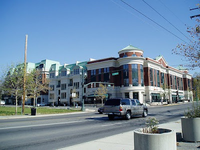

 The most remarkable differences, however, rest precisely on those municipal boundaries. Take Mound Street, for instance, which within Bexley is as pristine as anywhere else in the community.
 Just a block away, in Columbus, the character changes completely, but more interesting is the physical impedance separating the two cities resting along this eastern boundary, at Gould Street. This photo, taken from the Columbus side, shows a garage resting squarely on what would have been the east-west right-of-way where Mound Street intersects Gould Street, the later of which is little more than an alley.
 While it is possible this garage has always stood there, reinforcing the privately owned strip of land that bisects Mound Street, a map would suggest that the parcel bears the necessary physical dimensions to comprise a continuous right-of-way.
 So what happened here? Did someone in Bexley buy the public right-of-way to the street to transform it to private property, thereby impeding public access between Bexley and Columbus in this location? Obviously this is only speculation, but it certainly wouldn’t be the first example—I’ve even observed in an early blog post a scenario where an installed road barrier blocked automobile access between an apartment complex and a condo complex in suburban Indianapolis. In that instance, however, the barricade only inhibited automobile traffic, and pedestrians could walk around it. If my speculation is correct, here in Bexley the landowners have completely removed a segment of a collector street from public access.The evidence is subtle and may very well be a red herring, but it does appear that a certain contingent has made a conscious effort to alter the infrastructure in ways that weaken the accessibility between Bexley and surrounding Columbus. By why would a community attempt to do this? Obviously for the same reason that affluent gated communities have been cropping up across the country: the income differentials between the inside and outside are formidable, and the wealthy inside aims to stave off the undesirable perceived behavior characteristics of the outsiders. This near-east side of Columbus, though not uniformly poor, has not generally benefited from any of Bexley’s ostensible prosperity; all evidence suggests that it is considerably less affluent than the enclave it surrounds. The Community Data Center, under the management of Community Research Partners, provides useful cartographic economic indicators for all of Franklin County, revealing Bexley’s economic distinctiveness. This map showing median household income in 2000 by census tract is fully demonstrative: Bexley’s city limits are traced in yellow, and the Columbus Statehouse (the center of the city) indicated by a purple circle.
 Echoing these trends is a map of the 2007 assessed value of residential properties in the area, again using census tracts:
 Under both metrics, Bexley stands out as wealthier and with higher appraised home values than surrounding Columbus in all directions, but particularly to the east (across Alum Creek) and to the north (across the railroad tracks).As far as the perceived desirability of the community is considered, these efforts to keep Bexley carefully sequestered from its more socioeconomically diverse “parent” city have proven overwhelmingly successful. In short, Bexley is almost uniformly affluent; the surrounding neighborhoods of Columbus are not. But the physical barriers to Bexley, aside from a few privatized rights-of-way, are relatively modest. Bexley is hardly surrounded by a gate. Cars and pedestrians are free to travel in and out of the municipality, and can easily do so on the arterials or collector streets. So what has given this suburb such cachet, when other neighborhoods in Columbus city limits also feature architecturally distinct houses, tree lined streets, pedestrian commercial corridors, and the characteristics that have made urban living appealing to many?It helps to know a bit of the history of the area. Today, Bexley is a freestanding municipality, with its own mayor, city council, clerk of courts, police force, department of revenue, etc. It originated as a bedroom community called Pleasant Ridge, which emerged to house professors and their families after Capital University relocated in 1876 from its earlier site near Gooddale Park. Only after the Pleasant Ridge Improvement Association attracted infrastructure upgrades did the area begin to function as anything more than a rural assessment; the 1907 initiative added sidewalks, paved roads, and streetlights, encouraged tree planting, and restricted large signs, all in an effort to attract more people to the area. The efforts proved successful: by 1908 the Association decided to incorporate, combining several small neighborhoods to form the Village of Bexley. Incidentally, the City of Columbus sued the village shortly after this incorporation, contending that Bexley was annexed territory and subject to Columbus taxes. However, the Village successfully fought the suit and the Ohio Supreme Court ruled that Bexley was a separate and legally incorporated village and beyond the reach of Columbus taxes. Secure in its political autonomy, Bexley grew quickly and by 1931, the recent Census had proven that Bexley had achieved the minimum 5,000 residents in order to become a city. Its first mayor remained in office for 32 years. In short, Bexley was a fully incorporated community at a time when the surrounding Columbus neighborhoods were still new developments, and, in some cases (particularly to the south) virgin land. Columbus had grown eastward to meet Bexley and then continued to develop around it.Over the years the neighborhoods of Columbus that surround Bexley have met widely divergent fortunes: some have remained working or lower-middle class, some have declined significantly, while a few closest to the downtown (such as Old Town East) are showing early evidence of reinvestment and gentrification. Bexley, conversely, has consistently remained upper-middle and upper income regardless of its “parent” city’s vicissitudes. It has also remained largely college-educated, as reflected in this map from Community Research Partners:
 Correlations between income and education level are so powerful and widely known that the results of these analytical maps should come as no surprise. Bexley is an island of educated affluence. Equally unsurprising is the racial/ethnic composition of the community. Unfortunately the US Census Data does not isolate Bexley for analysis in its 2008 American Community Survey, so I will have to use 2000 results.
 A more refined examination, of course, would evaluate the census tracts individually through charts, but since maps are a more expressive tool at illustrating spatial organization I will demonstrate the percentage identifying racially as white by census tract according to 2000 data.
 Compared to the surrounding neighborhoods (particularly to the lower income north and east) Bexley is overwhelmingly white. In short, these political boundaries have in essence quarantined the municipality from poverty, low education, reduced property values, and racial diversity. The city’s political independence allows it to determine laws, budgets, millage rates, capital improvements, zoning—everything short of determining who gets in on a person-by-person basis.Yet many of those other policy initiatives could just as easily serve as a de facto means of limiting those who otherwise would hope to live in Bexley but cannot afford it. For example, Bexley could have required laws that require certain construction standards—a high quality building material, for instance, which ensures that homes will be of a certain minimum value, rendering them less affordable than if those standards did not exist. In the city’s earlier days of development, it could have required subdivisions to be platted at a certain minimum lot size—for example, two homes to an acre. The land costs would have been prohibitive to many. It could have restricted residential land use to single family homes of a minimum square footage, thereby precluding the construction of lower-cost multifamily or small residential units—also making it quite difficult for higher density apartment buildings to break ground. All of these actions would have entailed the practice of exclusionary zoning, ruled unconstitutional by the influential New Jersey Supreme Court Decision Southern Burlington County NAACP v. Mount Laurel Township first in 1975, then again in 1983 (with more enforcement powers) after public officials in Mount Laurel largely ignored the ruling the first time and continued to zone out affordability. Though the Mount Laurel Decision remains the most influential case determining the necessity of inclusionary zoning, most other decisions requiring the provision of affordable housing remain enactable only at the municipal or county level. No nationwide regulations prohibit zoning to exclude low-income persons.Bexley’s distinctive affluence could just as easily derive from forces completely divorced from the public sector. Redlining, in which mortgage lending companies would systematically deny loans to neighborhoods marked in red by a map (usually poor and racial minority), was a perfectly legal practice until federal legislation in the late 1960s and 1970s prohibited it. Most affordable housing advocates would argue that redlining still takes place under more covert methods. Restrictive covenants, in which certain obligations embedded in a deed prevent a homeowner from selling real property to a racial minority, also promoted and retained racial (and usually socioeconomic ) homogeneity in neighborhoods. This, too, was rendered illegal, first by Supreme Court ruling Shelley v. Kramer (1948) and, after that failed to stem the practice, the 1968 Civil Rights Act.While it is possible that Bexley engaged in some or all of these practices, the built environment does not immediately reveal evidence of exclusionary zoning. Lot sizes vary widely, as do the sizes of homes. In fact, recent Brookings Institution research indicates that Bexley and Columbus are the only two cities in the metro area with zoning that allows densities over 30 dwellings per acre. Building materials include brick, stone, and wood. And while the city is overwhelmingly wealthy and white, nearly 8% of the population is of some other race, which certainly makes it more heterogeneous than many other Columbus suburbs. In addition, persons of Jewish heritage—an religious group often targeted in restrictive covenants—comprise about a third of Bexley’s population. Without digging up Bexley’s entire legislative and zoning history, let’s hypothesize that none of these discriminatory practices were prevalent in the community. So how did Bexley get to be so rich? And, more importantly, how did it stay that way?The city’s incorporation at a time when it was a sleepy, prestigious bedroom community helped galvanize its exclusivity. Defining its boundaries as a small distinctive suburb at an early stage became a sort of self-fulfilling prophecy: it has always attracted people in Columbus with high aspirations (it also houses the Governor’s Mansion and the President of Ohio State University) and their own spending capacity have promoted a prevailing culture of affluence. Imagine if the Gold Coast of Chicago or the New York’s Upper West Side had incorporated as a separate community a century ago, or even if they did it today: it would be a freestanding municipality of elites. In essence, a suburban community outside the old center of Los Angeles did much the same thing when threatened by annexation from the parent city. Beverly Hills, now a virtual enclave of the superwealthy, incorporated in 1906, just two years before Bexley. Is Bexley the Beverly Hills of Columbus? Two other enclaves within Columbus, Grandview Heights and Worthington, are also quite affluent, but they are less striking because they directly abut some of the wealthier sections of Columbus; the contrast when crossing their boundaries is less striking. Conversely, Whitehall, a municipality about a mile to the east of Beckley that is also surrounded by Columbus, is not remotely affluent and in recent years has shown indications of escalating poverty levels. An enclave does not ensure exclusivity.One final map may prove the lynchpin to Bexley’s continued prosperity: the city’s school district boundaries, which, unsurprisingly, are conterminous with the city limits. Equally unsurprising is the fact that the Bexley Public School system is one of the highest-ranked in the state, but then a community such as Bexley has the deck stacked in its favor: the high assessed value of the homes translates to a robust tax base that may not even require a high mill rate to funding the –public schools generously. And what’s around it? The widely variable and sometimes abysmal Columbus Public Schools. The virtual absence of poverty in Bexley results in a minimal demand for low-income programs such as reduced lunch or subsidized sporting equipment. But the demographics itself favor an excellent school system: a municipality with such a high proportion of well-educated residents almost guarantees a high-achieving student body. Even if the schools were poorly funded (and they aren’t), the students would no doubt perform well. Like any city with sterling test scores, Bexley touts its school system, further enhancing its desirability and ensuring that real estate in the area remains high—and that a lower-income population (or even a middle class one) will never intrude upon its serenity by imposing greater educational burdens, or lowering the median test scores. Prestigious suburbs across the country share similar demographics, and their school systems are nearly always exemplary. Metro Columbus has a few of its own. But most of these other suburbs are not surrounded by a big city with broad swathes of poverty. The City of Bexley is basically impervious, as long as the well-oiled gears of its school system keep chugging along efficiently. The tree-lined streets, the walkable business district, the well-maintained older homes, the proximity to center of the state’s government—these factors in aggregate render the city immune from the higher crime and considerable poverty in the city that circumscribes it. Among the few palpable examples is a garage that blocks the right-of-way on Mound Street. But the intangibles exert a lasting power—the impeccable school system is the billy club that keeps the ne’er-do-wells away.If this conclusion comes across as an attack on Bexley, let me mitigate it by asserting that I am not attempting to castigate success. If Bexley achieved its prosperity through passive, “organic” means rather than exclusionary laws, it would scarcely deserve condemnation when dozens of other municipalities have deliberately excluded the poor and continue to do so. Bexley is a particularly striking example that is worthy of a dozen other socioeconomic evaluations. Part II may arrive far in the future as my current workload is intense, but I hope to examine the demographic implications of Bexley’s success, and how other municipalities—and particularly their school systems—can wield their own demographics into a position of economic opportunities, even if they lack the embedded advantages of a place like Bexley.
Most cities’ Public Works Departments have several sub-departments within the larger entity. For Indianapolis, those smaller units consist of Customer Service, Engineering, Environmental Services, and Operations. Obviously I have no idea what the day-to-day events in this department entail, so I always need to approach any serious shortcoming with measured criticism. But it doesn’t take 20/20 vision to recognize the oversight in the downtown photo below: I credit the City for at least providing a mid-block crosswalk here, something that far too many critical crossing points in downtown are sorely lacking. But did the Engineering Department—who purportedly designs and constructs such schemes—have any communication with the Operations Department, who maintains them? Or what about Veolia Water, who has managed Indianapolis Water since 2002, winning a bid to form nation’s largest water public-private partnership after the City bought the waterworks from a regulated utility? It’s hard to know how this boondoggle began. Most downtown hydrants and their associated water mains have been in place for ages, no doubt long before many of the crosswalks. Thus, it would appear that engineers striped the crosswalk to lead directly to this spot, which would be a practical and convenient location if it weren’t for the hydrant. And it wouldn’t be entirely fair for me just to use this photograph as the basis of criticism, which provides such a biased visual perspective as to reduce the photo to propaganda. Looking at it from the other side of Ohio Street demonstrates that the oversight isn’t quite so egregious:
 At least from this side of the street, the disabled access ramp is plainly visible, and, thanks to the Tactile Walking Surface Indicators (“dot tiles”), clearly felt by the visually impaired. And, by scanning across the street to the other sidewalk, the hydrant is clearly sufficiently offset to the right that a similar ramp should not be a problem. In addition, the alley directly to the right of the hydrant does have a handicapped ramp shrouded in the shadow, so a wheelchair could easily veer to the right, onto the alley, and then make a hard left to access the sidewalk. So, for a non-disabled person such as me to complain about this would be splitting hairs; the Public Works Department has far bigger fish to fry. And it is very possible that this remains a work in progress: while the crosswalk striping appears fairly old, the ramp with the dot tiles must be relatively new; dot tiles were not ubiquitous until a few years ago. But if I were to wager that it will be at least two years before the sidewalk with the hydrant receives an access ramp in order to complete the crosswalk, I suspect my pockets would be fuller than they are today.One can mostly likely attribute this blunder to one of two scenarios. 1) The full construction plan has stalled due either to budget or engineering constraints (it is possible that ramp installation could compromise the integrity of the water main that services this hydrant, making an otherwise simple process more costly through risk aversion). 2) The existing DPW budget for handicapped improvements, as meted out to Engineering and Operations, fails to make room for empathy. No doubt at least one engineer or project manager observed this shortcoming but had to shrug it aside because the budget only allows X ramp installations per year, and a remedy to the hydrant predicament here would total X + Y. And after all, a wheelchair can easily access through the path I articulated earlier, visible in the second of the two photos above. These two scenarios clearly bleed into one another; scenario 1 is a failure at the planning stage, and 2 occurs during implementation. The result that we see is a stalemate. Nothing is going to change until someone with a legitimate case files a public grievance. By most measurements, we have much ado about nothing with this minor crosswalk in a part of downtown that hibernates on the weekends. But attention to seemingly petty public infrastructural details—the absence of pedestrian-oriented street signs is another Indianapolis weakness that I blogged about in the past—remains the most efficient, workmanlike means of instilling a sense of stewardship towards public space. It is no less important than a consistent removal of graffiti, except that both the private and public sector share the burden of vandalism. One can only hope that the situation that finally impels the DPW to complete this crosswalk doesn’t involve the injury of a disabled person.
When a community takes a banal public works project and gussies it up, it is certain to divert a visitor’s gaze—what normally blends in to the landscape because of its ubiquity and sheer ordinariness has suddenly become remarkable. Other initiatives simply attempt to camouflage what the public almost unanimously agrees is an ugly piece of infrastructure. But when the improvements of that electric substation, those fire hydrants, overpasses, or retaining walls employ a subtle design implemented with fiscal responsibility, the positive branding for the associated community could, over time, transcend the cost. The difficulty of capturing this ROI through a cost/benefit analysis no doubt stalls some of these public-sector beautification initiatives, but every now and then a smaller town pulls off something charming, exemplified by this water tower outside the southern Indiana town of Scottsburg, on the east side of busy Interstate 65: Since the Industrial Revolution, these top-heavy leviathans have presided over communities of all sizes, serving a purpose that the public overwhelmingly neither questions nor fully understands. They typically elevate a reservoir of water to use during a power failure (when the pumping stations cannot operate). The height of at least 100 feet induces a level of hydrostatic pressure through gravity that expedites widespread distribution across the piping system and the ability to flow powerfully from a tap. While large buildings in urban America routinely host water towers on their roof tops, they frequently blend in with the clutter of other prominently tall structures nearby. The freestanding, bulbous “mushroom” water towers play a quietly iconic role across suburban and small-town America, but rarely do they feature anything more than the name of the town in large black lettering. The City of Scottsburg, Indiana’s decision to place the town’s name in a handsome serif font with a decorative border adds distinction without being gaudy; it announces rather than merely informs.Is the Scottsburg water tower design remarkable? Not really—but that in itself makes it worthy of recognition. On a scale of ambition from 1 to 10, 1 representing the standard water tower, Scottsburg may only get a 2 or a 3. But a 2 or 3 for a town of 6,000 amidst a sea of 1’s, these small efforts indicate a community willing to demonstrate a greater-than-average degree of stewardship for its most ordinary spaces. I can recall in particular that the suburbs of Chicago are littered with boring water tower graphics. Another contrast for Scottsburg is the water tower in Carmel, the state’s wealthiest large city (with a tremendous infrastructural investment to boot), which may have a more Spartan design but made no effort to distinguish itself in terms of an attractive paint job. The most remarkable water tower designs across the world are unambiguously flashy—Europe has quite a few elegant brick-and-mortar examples, the likes of which would probably infuriate most US taxpayers. In America the most eye-catching towers typically involve kitschy fiberglass pop art, such as the corn tower in Rochester, Minnesota or the peach-with-a-posterior in Gaffney South, Carolina. Perhaps these elaborate confections were cheap to build as well, or maybe they didn’t require a dime of public money, but they convey a certain extravagance that makes them a tough sell in small towns like Scottsburg. For example, Ypsilanti Michigan’s notorious “brick dick” water tower is a deserved community icon, but its Joliet limestone base was undoubtedly a formidable investment at the time of its construction over a century ago.My opinion is that Scottsburg inadvertently followed the example of Florence, Kentucky, which initially decorated its tower with an advertisement for the new Florence Mall, until the Commonwealth determined that it violated a law by exceeding the height limits for a sign promoting a business that didn’t exist directly along the interstate. The Mayor of Florence cleverly opted to adjust the “M” of “Mall” to a “Y” through a few careful strips of paint, saving the city hundreds of dollars over a complete repainting and transforming the tower into a whimsical local treasure. It’s nothing fancy, but the tower has said “FLORENCE Y’ALL” for the past thirty years. I hardly know what the residents of Scottsburg think of their water tower, but it’s far more likely to elicit positive publicity than it otherwise would, and at the fraction of the cost of those opuses in Michigan or South Carolina. A few extra strokes of the paintbrush elevated it above the mundane. During the holiday season, the Town drapes the tower in Christmas lights along the poles and prominent edges, creating a colorful beacon that motorists can see along Interstate 65 miles before they actually pass it. Across the nation, water towers elicit a variety of reactions, from complaints of public eyesores to cherished historic landmarks—my suspicion is that the folks of Scottsburg have something they’d hate to give up.This essay could easily be much ado about nothing, but these small, thoughtful design gestures contribute far more to building a favorable impression about a place incrementally. A little down the street from Scottsburg, the small city of Columbus, Indiana has incorporated stylistic verve into its bike racks:
 These multicolored, jauntily angled C’s echo the logo the City has adapted the past few years as part of its broader tourist initiative.
  As many know, Columbus is unique for having greater civic support for innovative design than just about any city of its size in the country—perhaps the world. (Indianapolis, unfortunately, can only dream of such organized design advocacy.) This nationally recognized little city may offer far better proof of what innovation in the built environment can achieve than a largely unknown town like Scottsburg, but somebody clearly sewed the seed among Scottsburg’ citizenry—perhaps unconsciously—and it blossomed into a far better piece of interstate folklore than the millions of passers-by are used to seeing.
The emerging waterfront park of Louisville deserves separate attention through a special posting, but until I have explored and researched it more I’ll leave viewers with this bizarre warning sign in the water element, a linear pool that is clearly sequestered from the actual Ohio River: While I’m aware that there are twice as many parts hydrogen to every part oxygen, is this ever cause for alarm? Clearly I’m not the only one to ruminate on this, but most agree that it must be a joke. (It’s even featured prominently on the waterfront’s website.) If it really were heavy water (deuterium oxide, or 2H20) it could prove highly dangerous. But if that were the case, one would hope there’d be more than a “no swimming” pictorial warning beside it. Clearly, on a hot summer day, the local children are ignoring both warnings:
 Apparently, another concerned onlooker took the trouble to investigate and the city officials were forced to lay down their hand:
"It seems authorities, tired of swimmers splashing around in the fountains and leery of the possibility of bacteria developing in the water, were hoping the public would be scared away by the foreboding signs — even though there was nothing amiss. David Karem, executive director of the Waterfront Development Corp., said he had the signs made in the hopes that a lack of understanding of the chemical makeup of water and the association of hydrogen to dangerous weapons such as the hydrogen bomb would keep the fountains people-free... Unfortunately for Karem, the hot summer days and a few good students have him fighting what he knows might be a losing battle."
Juxtaposing such a message with an actual “no swimming” command dilutes both the irony intended to give the written sign humor, as well as the implied seriousness of the literal request for the public not to swim. The public ignores both. The one identifiably successful impact of the sign is that it has evolved into a sort of pop-cultural meme, popping up now and then in the blogosphere by hapless writers—like me. Here’s hoping future expansions of the Louisville waterfront include similarly idiosyncratic signage; even better if the signage achieves its imperative goal, or that it’s actually funny.


 Any unlabelled gray regions on the map above are “unexcluded towns” with limited self-governance but are essentially incorporated within Indianapolis. They have limited political authority on their own. As you can see, three of the four excluded communities—Southport, Beech Grove, and Speedway—are enclaves, functioning much the same way as Bexley, with the city of Indianapolis surrounding them.


